
Minicoy facts for kids
 |
|
| Lua error in Module:Location_map at line 420: attempt to index field 'wikibase' (a nil value). | |
| Geography | |
|---|---|
| Location | Arabian Sea |
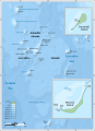
| Archipelago | Lakshadweep |
| Adjacent bodies of water | Indian Ocean |
| Total islands | 1 |
| Major islands |
|
| Area | 4.801 km2 (1.854 sq mi) |
| Highest elevation | 2 m (7 ft) |
| Administration | |
| Territory | Union territory of Lakshadweep |
| District | Lakshadweep |
| Island group | Minicoy Islands |
| Tehsils of India | Minicoy Tehsil |
| Subdivisions of India | Minicoy Ward |
| Largest settlement | Minicoy Bada (pop. 9000) |
| Demographics | |
| Population | 10,700 (2014) |
| Pop. density | 2,229 /km2 (5,773 /sq mi) |
| Ethnic groups | Malayali, Mahls |
| Additional information | |
| Time zone | |
| PIN | 682559 |
| Telephone code | 04892 |
| ISO code | IN-LD-09 |
| Literacy | 84.4% |
| Avg. summer temperature | 32.0 °C (89.6 °F) |
| Avg. winter temperature | 28.0 °C (82.4 °F) |
Minicoy, also called Maliku by locals, is a beautiful island in Lakshadweep, India. It is part of the Maliku atoll, which is the southernmost atoll in the Lakshadweep group of islands. Minicoy is like a small town and is managed by the Indian union territory of Lakshadweep. This island is located about 425 kilometers (264 miles) west of Trivandrum, the capital city of Kerala.
Contents
Island Names: Minicoy and Maliku
Minicoy is known as Maliku in the local language, Dhivehi. This language is also the official language of the Maldives. Dhivehi is similar to the Sinhala language spoken in Sri Lanka.
How "Mahl" Became the Language Name
The Lakshadweep government calls the Dhivehi language "Mahl." This happened because of a misunderstanding. In the early 1900s, a British officer visited Minicoy. He asked a local person what their language was. The islander replied "Dhivehi-bas." The officer looked confused. So, the islander then said "Mahaldeebu," knowing that people on the Indian subcontinent called the Maldives by that name. The British officer then officially wrote down the language of Minicoy as Mahl.
Ancient Names and Meanings
The old name for Maliku was Mahiladū, which means "women's island." This name comes from an old language called Elu Prakrit. Another idea is that the name Maliku came from Arab traders. They might have called it Jazirat al-Maliku, meaning "the island of the king."
The Story Behind "Minicoy"
Minicoy islanders used to travel to the Nicobar Islands across the Bay of Bengal. People in the Maldives and Minicoy believed the Andaman and Nicobar Islands were home to cannibals. So, they called these islands "Minikaa-raajje," which meant "cannibal kingdom."
One day, a British official asked a Minicoy islander his home island's name. The islander said he was from Maliku but often lived in "Minikaa-raajje" (Nicobar). The official thought Maliku and Minikaa were the same place. He recorded the islander's home as "Minikaa," which later became "Minicoy" in English. It's interesting how a misunderstanding gave the island a name that sounds like "cannibal" in its own language!
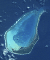
Island Geography

Minicoy is the second largest island in Lakshadweep. It is also the southernmost island in the group. It lies about 201 kilometers (125 miles) south-southwest of Kalpeni. It is also 125 kilometers (78 miles) north of Thuraakunu in the Maldives.
Size and Features
The atoll where Minicoy is located is about 10 kilometers (6.2 miles) long. Its widest part is about 6 kilometers (3.7 miles). The main island is on the eastern side of the lagoon. It is about 10 kilometers long from north to south. In its southern part, it is about 1 kilometer (0.62 miles) wide. The northern part is a narrow strip of sand, sometimes less than 100 meters (328 feet) wide.
Minicoy is almost completely covered with coconut trees. A famous landmark on the island is the Minicoy Island Lighthouse. It was built in 1885 when the British ruled the area.
Viringili Islet
On the southern side of the main island is a small, uninhabited islet called Viringili. It is only about 200 meters (656 feet) long. In the past, people from Minicoy who had certain illnesses used to live on this island.
The Lagoon and Channels
The Maliku Atoll has a lagoon with two entrances on its northern side. These are called Saalu Magu and Kandimma Magu. The western side of the atoll has a narrow reef and coral rocks. The lagoon inside is sandy and not very deep, usually less than 4 meters (13 feet). It also has some coral patches.
Minicoy is part of the Union Territory of Lakshadweep, India. The Nine Degree Channel separates Minicoy from the Laccadive Islands. The closest island to Minicoy is Thuraakunu in the Maldives. Since 1956, the Indian Government has not allowed direct travel between Minicoy and Thuraakunu. This is despite them being very close and having similar cultures.
The wide channel between Minicoy and Ihavandippulhu in the Maldives is traditionally called Maliku Kandu. On maps, it is known as the Eight Degree Channel.

Minicoy Villages
Minicoy Island has eleven villages. They are listed from north to south:
- Kendiparty
- Pallessery
- Kudehi
- Funhilol
- Aloodi
- Sadivalu
- New Boduathiri
- Rammedu
- Boduathiri
- Aoumagu
- Bada
Island Climate
Minicoy has a tropical savanna climate. This means it has warm temperatures all year round. It rains for most of the year, with only January to March being drier months.
| Climate data for Minicoy (1981–2010, extremes 1901–2012) | |||||||||||||
|---|---|---|---|---|---|---|---|---|---|---|---|---|---|
| Month | Jan | Feb | Mar | Apr | May | Jun | Jul | Aug | Sep | Oct | Nov | Dec | Year |
| Record high °C (°F) | 32.8 (91.0) |
33.2 (91.8) |
34.3 (93.7) |
35.6 (96.1) |
36.7 (98.1) |
34.5 (94.1) |
33.4 (92.1) |
33.4 (92.1) |
33.2 (91.8) |
33.3 (91.9) |
33.2 (91.8) |
33.3 (91.9) |
36.7 (98.1) |
| Mean daily maximum °C (°F) | 31.1 (88.0) |
31.4 (88.5) |
32.4 (90.3) |
33.0 (91.4) |
32.8 (91.0) |
31.3 (88.3) |
30.9 (87.6) |
30.9 (87.6) |
30.9 (87.6) |
31.1 (88.0) |
31.0 (87.8) |
31.2 (88.2) |
31.5 (88.7) |
| Daily mean °C (°F) | 27.6 (81.7) |
27.9 (82.2) |
29.0 (84.2) |
30.0 (86.0) |
29.7 (85.5) |
28.4 (83.1) |
28.2 (82.8) |
28.2 (82.8) |
28.2 (82.8) |
28.1 (82.6) |
27.9 (82.2) |
27.8 (82.0) |
28.4 (83.2) |
| Mean daily minimum °C (°F) | 24.1 (75.4) |
24.5 (76.1) |
25.6 (78.1) |
26.8 (80.2) |
26.7 (80.1) |
25.6 (78.1) |
25.4 (77.7) |
25.4 (77.7) |
25.4 (77.7) |
25.1 (77.2) |
24.8 (76.6) |
24.5 (76.1) |
25.3 (77.5) |
| Record low °C (°F) | 17.8 (64.0) |
17.2 (63.0) |
19.1 (66.4) |
20.7 (69.3) |
19.7 (67.5) |
20.4 (68.7) |
19.7 (67.5) |
19.7 (67.5) |
20.3 (68.5) |
19.4 (66.9) |
17.2 (63.0) |
16.7 (62.1) |
16.7 (62.1) |
| Average rainfall mm (inches) | 30.3 (1.19) |
16.5 (0.65) |
21.6 (0.85) |
50.2 (1.98) |
168.0 (6.61) |
315.5 (12.42) |
246.1 (9.69) |
214.2 (8.43) |
150.1 (5.91) |
163.5 (6.44) |
152.3 (6.00) |
65.5 (2.58) |
1,593.7 (62.74) |
| Average rainy days | 2.0 | 1.4 | 1.3 | 3.4 | 9.2 | 16.8 | 14.3 | 11.9 | 10.7 | 9.5 | 8.1 | 3.7 | 92.2 |
| Average relative humidity (%) (at 17:30 IST) | 71 | 70 | 69 | 71 | 75 | 81 | 80 | 79 | 78 | 78 | 77 | 73 | 75 |
| Mean monthly sunshine hours | 269.7 | 248.6 | 272.8 | 261.0 | 217.0 | 138.0 | 151.9 | 192.2 | 195.0 | 229.4 | 219.0 | 260.4 | 2,655 |
| Mean daily sunshine hours | 8.7 | 8.8 | 8.8 | 8.7 | 7.0 | 4.6 | 4.9 | 6.2 | 6.5 | 7.4 | 7.3 | 8.4 | 7.3 |
| Source 1: India Meteorological Department (sun, 1971–2000) | |||||||||||||
| Source 2: Tokyo Climate Center (mean temperatures 1981–2010) | |||||||||||||
Island History
Early Buddhist Times
About 800 years ago, Minicoy had a Buddhist past. In an area called "Salliballu," you can still find remains from this time. Archaeologists found two large mounds of ruins there. These were from a stupa (a Buddhist monument) and another related building.
The Archaeological Survey of India explored these sites in the 1980s. They found a damaged large Buddha head buried in the area. The name "Salliballu" comes from the local word for "Christian cross." Locals thought an inscription with a "cross" was found there. However, it was probably a cross-shaped mandala or visvavajra, which are common in Buddhist sites.
Princesses and Island Families
Local stories say that two princesses from the Maldives, Kamborani and Kohoratukamana, came to Maliku. When they arrived, the Tivaru people, who lived there before, left the island for Sri Lanka. The descendants of Kamborani became the "bodun," who owned land and ships. The descendants of Kohoratukamana became the "niamin," who were captains. Other groups on the island came from their crew members.
Colonial Era: British Influence
Before the 16th century, the Laccadives (including Minicoy) were ruled by the Kolathiri Raja of Chirakkal in Kerala. When the Portuguese became powerful in the region, the Kolathiri ruler gave control of the islands to the Ali Raja of Cannanore.
However, the kings and queens of the Maldives also claimed Minicoy. Their official papers often mentioned their rule over "Malikaddu Midhemedhu," meaning "Between Maliku (Minicoy) and Addu." Addu was the southernmost island under the Maldive kings. This shows that Minicoy was seen as part of the Maldive kingdom for a long time.
Under British Rule
In 1857, Minicoy's control shifted from the East India Company to the British Indian Empire. This happened when Queen Victoria became Empress. In 1790, Maliku was given to the British East India Company by Junumabe Ali-Adi Raja Bibi II. She was the Ali Raja of Cannanore. She was allowed to manage Maliku if she paid a tribute to the Company.
She tried to get full control back, but in 1824, her successor, Mariambe Ali-Adi Raja Bibi, officially agreed that the East India Company was in charge of Maliku. They continued to pay tribute. In 1905, due to heavy debts, Mohamed Ali-Adi Raja agreed to give up full control of Minicoy. He died before the official transfer. His successor, Imbicchi Ali-Adi Raja Bibi, finally signed over Minicoy to Emperor Edward VII on February 9, 1909. After this, Minicoy became part of the Malabar District.
After India's Independence
Joining India
After India became independent in August 1947, the British territories were divided between India and Pakistan. The rulers of the smaller states could choose which country to join. Since Minicoy was under British rule, India held a special vote (called a plebiscite) in 1956. The people of Minicoy voted to join the Indian Union.
Becoming a Union Territory
On November 1, 1956, Minicoy became part of the Union Territory of Laccadive, Minicoy, and Aminidivi Islands. This territory was later renamed Lakshadweep in 1973. At this time, the Maldives was still under British control.
India-Maldives Agreement

In December 1976, India and the Maldives signed a treaty about their sea borders. This treaty officially placed Minicoy on the Indian side of the boundary. In 1982, there was a brief misunderstanding when a Maldivian official suggested Minicoy belonged to the Maldives. However, the Maldives government quickly and officially denied this claim.
India and the Maldives have a friendly relationship. They work together in economic and military areas. India also helps with the security of the Maldives.
Island Population
Religion in Minicoy Island (2011) Islam (96.58%) Hinduism (2.5%) Christianity (0.78%) Others (0.1%) Not Stated (0.04%)
According to the 2011 India census, Minicoy Island had a population of 10,447 people. About 51% of the population were males and 49% were females.
Minicoy has a high literacy rate of 83.93%. This is higher than India's national average of 74.04%. For males, the literacy rate is 85.82%, and for females, it is 81.93%. About 9.6% of the population in Minicoy is under 6 years old.
Getting Around Minicoy
Travel by Sea
Several passenger ships connect Lakshadweep with Kerala on the mainland. These include MV Corals, MV Lagoons, MV Amindivi, MV Arabian Sea, MV Bharat Seema, MV Dweep Setu, MV Kavaratti, MV Lakshadweep Sea, and MV Minicoy. The journey by sea usually takes between 14 and 20 hours.
The Lakshadweep authorities are looking to invest in the Port City of Kerala, Kollam. They want to build a passenger terminal there. This would include places for people to stay and an office to help Minicoy residents traveling to Kollam Port. Historically, Lakshadweep has been connected to the mainland through the ports of Kollam, Kochi, and Beypore. Minicoy is actually closer to Kollam than to Kochi or Beypore.
Travel by Air
Agatti Airport is the only civilian airport in Lakshadweep. You can take a helicopter from Agatti to Minicoy all year round. The flight from Cochin to Agatti takes about one hour and thirty minutes. Flights operate six days a week.
In July 2024, the Indian Government approved a plan to build an airport at Minicoy Island. This airport will be a military base for all three armed forces (army, navy, air force). It will also have a civilian area for regular flights. This new airbase will be able to handle fighter jets, long-range drones, and military transport planes, as well as commercial flights. The Indian Air Force is leading this project. It will be used by all parts of the Indian Armed Forces and the Indian Coast Guard.
Notable People
- Ali Manikfan, born 1938
Images for kids
-
Satellite picture of Minicoy
-
Map of Lakshadweep


See also
 In Spanish: Maliku para niños
