
Nicobar Islands facts for kids
The Nicobar Islands are a group of islands in the eastern Indian Ocean. They are a part of India.
There are 22 islands in the Nicobar chain, and they come in different sizes. The biggest island is Great Nicobar. All together, the islands cover about 1,841 square kilometers (711 square miles). The highest point in the Nicobars is Mount Thullier, which is 642 meters (2,106 feet) tall.
In 2001, about 42,026 people lived on the islands. Around 65% of these people are indigenous (native) groups like the Nicobarese and Shompen peoples. The other 35% are people who have moved there from other parts of India and Sri Lanka.
Contents
Where are the Nicobar Islands?
The Nicobar Islands are located southeast of the main land of India. They are about 1,300 kilometers (808 miles) away from India, across the Bay of Bengal.
To the north, the Nicobar Islands are separated from the Andaman Islands by a 150-kilometer (93-mile) wide stretch of water called the Ten Degree Channel. To the southeast, they are only 189 kilometers (117 miles) from the Indonesian island of Sumatra. The Andaman and Nicobar islands together form a natural barrier between the Bay of Bengal and the Andaman Sea.
Before the big earthquake and tsunami in 2004, a place called Indira Point on Great Nicobar was the southernmost tip of India.
Island Groups
The Nicobar Islands are divided into three main groups:
Northern Group
- Car Nicobar (127 km²)
- Batti Malv (2 km²) - This island is not inhabited by people.
Central Group
- Chowra (8 km²)
- Teressa (101 km²)
- Poahat (13.3 km²)
- Katchal (174 km²)
- Camorta (188 km²)
- Nancowry (67 km²)
- Trinket (86 km²)
- Isle of Man - Not inhabited.
- Tillangchong (17 km²) - This island is a special place for wildlife.
Southern Group
- Great Nicobar (1045 km²) - The largest island.
- Little Nicobar (157 km²)
- Kondul (4 km²)
- Pulomilo (1 km²)
- Meroe, Trak, Treis, Menchal, Cubra, Pigeon, and Megapod - These small islands are not inhabited. Megapod is also a wildlife sanctuary.
How the Islands are Governed
The Nicobar Islands are part of the Andaman and Nicobar Islands, which is a Union territory of India. A Union Territory is like a special administrative area directly controlled by the central government of India.
The capital city for both the Andaman and Nicobar Islands is Port Blair, located on South Andaman Island. The entire Union Territory is divided into two main areas: the Andaman district and the Nicobar district. The Nicobar district includes all of the Nicobar Islands.
The Indian Government has rules about who can visit the Nicobar Islands. You usually need a special permit to go there, and people who are not Indian citizens are generally not allowed to visit these islands.
Images for kids
-
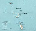
A map showing the location of the Nicobar Islands.
-
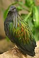
A Nicobar pigeon. This bird is named after the Nicobar Islands, but it also lives in many other places like the Malay Archipelago.


See also
 In Spanish: Islas Nicobar para niños
