
Craigend, Glasgow facts for kids
Quick facts for kids Craigend |
|
|---|---|
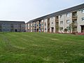
.jpg) Collessie Drive (2018) |
|

Craigend
|
|
| OS grid reference | NS650667 |
| Council area | |
| Lieutenancy area |
|
| Country | Scotland |
| Sovereign state | United Kingdom |
| Post town | GLASGOW |
| Postcode district | G33 5 |
| Dialling code | 0141 |
| Ambulance | Scottish |
| EU Parliament | Scotland |
| UK Parliament |
|
| Scottish Parliament |
|
Craigend is a neighborhood in the Scottish city of Glasgow. It is located north of the River Clyde. You can find it just west of Garthamlock and east of Hogganfield Park. It is also next to Ruchazie.
The M8 motorway separates Craigend from Cranhill and Queenslie to the south. Junction 11 of the M8 motorway serves the area directly. To the north, there is an open area called Cardowan Moss nature reserve. Two water towers are local landmarks in Craigend. They used to light up at night, but they don't anymore.
What's Craigend Like?
In the 1970s and 1980s, Craigend was seen as a very nice place to live. It had many houses with their own front and back doors. This was different from nearby areas like Ruchazie and Garthamlock, which had more apartment buildings (called tenements).
Today, some of the older buildings in Craigend are not as new as those in other areas. However, many parts of the East End of Glasgow have been updated. This is part of a big plan to make the area better.
Schools in Craigend
Craigend is home to three schools. Two of them are non-religious schools: Sunnyside and Avenue End. The third school is St Rose of Lima, which is a Roman Catholic school.
Images for kids
-
Apartment buildings at Glenraith Square

