Queenslie facts for kids
Quick facts for kids Queenslie |
|
|---|---|
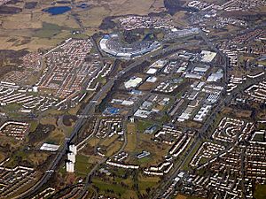
 Aerial view from the west; Queenslie at centre-right of image between Glasgow Fort and Cranhill |
|
| OS grid reference | NS658656 |
| Council area | |
| Lieutenancy area |
|
| Country | Scotland |
| Sovereign state | United Kingdom |
| Post town | GLASGOW |
| Postcode district | G33 |
| Dialling code | 0141 |
| Ambulance | Scottish |
| EU Parliament | Scotland |
| UK Parliament |
|
| Scottish Parliament |
|
Queenslie is a district in the Scottish city of Glasgow.
It started in the 1950s as a large area for businesses and factories, called an industrial estate. There was also a small area with homes and a school. Over time, the homes became old and worn out. So, in the 1990s, the local government decided to remove them. They expanded the industrial area instead. Today, Queenslie has the biggest industrial estate in Glasgow.
Contents
Where is Queenslie Located?
Queenslie is in the east of Glasgow. It is next to Cranhill, with Stepps Road as the border. The M8 motorway separates Queenslie from Garthamlock to the north. This motorway was once the Monkland Canal. Bartiebeith Road forms the south-east border with Wellhouse. These areas also have homes built around the same time as Queenslie.
To the south-west is the A8 Edinburgh Road. This is a big main road and a bus route. The areas of Springboig and Barlanark are across this main road.
A Brief History of Queenslie
Queenslie is part of the larger Easterhouse area in north-east Glasgow. This area was developed after World War II. Many new homes were needed for people in Glasgow. These homes were for families living in crowded places. Many came from older parts of the city.
The land where Queenslie now stands used to be farmland. It was mainly made up of Easter Queenslie and Wester Queenslie farms. On an old map by William Roy from the 1700s, the area was called 'Quinsley'. This name later changed to Queenslie.
How Queenslie Developed
Modern Queenslie began as an industrial estate in the 1950s. Soon after, homes were built. These were three-storey buildings called tenements. A primary school was also added. The main streets in Queenslie included Horndean Crescent and Penston Road.
In the 1960s and 1970s, Queenslie was a lively place. It had a strong community spirit. Many people who lived there also worked in local factories. One famous factory nearby was Olivetti.
Changes Over Time
The homes in Queenslie were built close together. They were also in an area already surrounded by factories. This made it easier to change the land's use. In the mid-1990s, all the homes were taken down. The primary school was also demolished. The industrial estate then grew to cover this space.
Other nearby areas also saw big changes. Schools that served Queenslie closed down. This happened as the number of people living there fell. Many older homes were removed. They were replaced with fewer, newer, and better-quality homes. Some existing homes were also renovated.
Queenslie Today
The industrial estate in Queenslie is still very busy. Many businesses operate there. Its location next to the M8 motorway is very useful. It is also close to other motorways. These roads connect Queenslie to places all over Scotland and beyond.
Besides businesses, Queenslie also has an important facility. It is one of Glasgow's four main waste recycling centers. This center helps manage waste for the north-east part of the city.
 | Emma Amos |
 | Edward Mitchell Bannister |
 | Larry D. Alexander |
 | Ernie Barnes |


