
Kilcreggan facts for kids
Quick facts for kids Kilcreggan
|
|
|---|---|
 Kilcreggan Pier |
|

Kilcreggan
|
|
| Population | 1,280 (2020) |
| OS grid reference | NS 23800 80500 |
| • Edinburgh | 63 mi (101 km) |
| • London | 364 mi (586 km) |
| Council area |
|
| Lieutenancy area |
|
| Country | Scotland |
| Sovereign state | United Kingdom |
| Post town | Helensburgh |
| Postcode district | G84 |
| Dialling code | 01436 |
| EU Parliament | Scotland |
| UK Parliament |
|
| Scottish Parliament | |

Kilcreggan (Scottish Gaelic: Cille Chreagain) is a charming village located on the Rosneath Peninsula in Argyll and Bute, West of Scotland. It sits on the northern shore of the Firth of Clyde.
In the past, Kilcreggan was a popular summer escape. Wealthy shipowners and merchants from Glasgow would travel here by Clyde steamers. This made the village easy to reach, even though it's about 25 miles (40 km) west of Glasgow by boat. Many grand houses were built along the shore during this time. Some of these old homes are still occupied, while others have been turned into flats.
Contents
Exploring Kilcreggan
Kilcreggan is at the very end of the Rosneath Peninsula. It's nestled between two sea lochs: the Gare Loch and Loch Long. Getting there by road means a journey of about 38 miles (61 km).
Village Layout and Views
The main road, B833, runs along the shore through the village. Just east of Kilcreggan pier, the road turns north inland. It doesn't continue along the shore past Portkil Bay. About 2 miles (3 km) north of Kilcreggan, the road reaches the village of Rosneath. From there, it continues north along the shores of the Gare Loch.
Most houses in Kilcreggan face south. This gives them amazing views across the Clyde. You can see the towns of Gourock and Greenock. On a clear day, you might even spot the Isle of Arran further down the firth.
Large, attractive houses stretch west from the pier towards Baron's Point. This point marks the southern entrance to Loch Long. The village of Cove is nearby. It looks across Cove Bay towards Blairmore. These places are only about 2 miles (3 km) apart, but they are separated by the deep waters of Loch Long.
East of the pier, houses at Portkil extend down to Portkil Bay. A 413-foot (126 m) hill at Rosneath home farm has a television mast on top.
Getting Around by Ferry
A ferry service connects Kilcreggan pier to Gourock across the Clyde. This service is important for locals and visitors. It is supported by Strathclyde Partnership for Transport.
For many years, the ferry also went to Helensburgh across the Gare Loch. Different companies have operated the ferry over time. Currently, CalMac runs the service. They lease a vessel called Chieftain for the route.
Kilcreggan's History and Community
Kilcreggan has a rich history in terms of local government. It was once part of the historic county of Dunbartonshire.
Local Government Changes
Before 1975, Kilcreggan was part of the joint police burgh of Cove and Kilcreggan. A police burgh was a type of local government area. After 1975, it became part of Dumbarton District and Strathclyde Region.
Since the 1990s, Kilcreggan has been part of Argyll and Bute unitary authority. This means Argyll and Bute is responsible for local services in the area.
Community Life
The local church, Craigrownie Parish Church of Scotland, serves the communities of Ardpeaton, Cove, and Kilcreggan. It plays an important role in village life.
Gallery
-
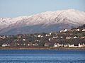
Houses in Kilcreggan west of the pier: the snowy hills in the background are on the other side of Loch Long.
-
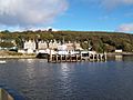
The pier formed the original focal point of the village.
-
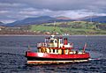
The Kenilworth seen in front of Portkil


See also
 In Spanish: Kilcreggan para niños
