
Kilpatrick Hills facts for kids
The Kilpatrick Hills are a range of hills in central Scotland. They stretch from Dumbarton in the west to Strathblane in the east. Strathblane separates these hills from the Campsie Fells to the east. To the north, you'll find part of the beautiful Loch Lomond and the Trossachs National Park.
Around the west and south edges of the hills are towns like Balloch, Dumbarton, Milton, Bowling, Old Kilpatrick, Clydebank, Bearsden, and Milngavie. Most of the hills are in West Dunbartonshire, but parts also reach into East Dunbartonshire and the Stirling area.
The two highest points are Duncolm (1,314 feet (401 m)) and Fynloch (1,313 feet (400 m)). The Kilpatrick Hills offer many great views and interesting spots. Some of the most famous are Doughnot Hill and The Whangie. You'll also find several reservoirs here.
These hills were formed by volcanoes a very long time ago. Later, huge glaciers changed their shape.
How the Hills Were Formed

The Kilpatrick Hills are part of something called the Clyde Plateau Lavas. This means they were created by ancient volcanoes about 340 million years ago! Most of the rocks here are basalt, which comes from old lava flows. You can also find types of rock called tuff and agglomerate, which are made from volcanic ash and broken rock pieces.
One of the most interesting spots is The Whangie, in the north of the Kilpatricks. It's a narrow crack in the hillside, like a giant slice. It can be up to 10 metres (33 ft) high and about 100 metres (330 ft) long, and you can walk right through it!
For a long time, people thought The Whangie was formed by a glacier pulling a piece of the hill away. But newer research suggests it was caused by a landslide. During an ice age, a glacier slowly wore away the bottom of the rock, opening up cracks and causing this amazing chasm to form.
The name "Whangie" might come from an old Scots word for "slice," like a "whang o' cheese." A fun local story says that the devil created it by flicking his tail as he flew past!
Ancient Discoveries
The southern slopes of the hills are home to several very old sites. One is a chambered cairn at Carnhowit. This is a type of ancient burial mound made of stones, located near Cochno Loch at a height of 275 metres (902 ft).
There are three other cairns, which might be from the Bronze Age (a time when people used bronze tools). One is called Maidens Paps, near Jaw Reservoir. Both it and another cairn on Cochno Hill are around 250 metres (820 ft) high. The third cairn is at Wester Duntiglennan, about 150 metres (490 ft) high.
People have also found cists at Cochno and Duntocher. A cist is a small stone box or coffin used for burials. On the lower slopes, below 150 metres (490 ft), you can find groups of cup and ring marks carved into rocks. These mysterious carvings are mostly around Auchnacraig and Whitehill, with others further west towards Bowling, West Dunbartonshire.
Hill Names and Heights
The Kilpatrick Hills get their name from the village of Old Kilpatrick, which sits at the bottom of their southern side.
Here are some of the higher points in the Kilpatrick Hills:
| Name | Height | Notes |
|---|---|---|
| Duncolm | 1,314 feet (401 m) | This is the highest point! It has a trig point (a marker used for surveying). Its name comes from the Scots Gaelic words dun (hill-fort or hill) and Colm (referring to Saint Columba). |
| Fynloch | 1,313 feet (400 m) | |
| Middle Duncolm | 1,289 feet (393 m) | |
| Darnycaip | 1,232 feet (376 m) | |
| Doughnot Hill | 1,227 feet (374 m) | Has a trig point. |
| The Slacks | 1,199 feet (365 m) | Has a trig point. |
| Auchineden | 1,171 feet (357 m) | Has a trig point. |
| Jesus' Thimble | 1,171 feet (357 m) | Has a trig point. |
| Craigarestie | 1,166 feet (355 m) | |
| Meikle White Hill | 1,163 feet (354 m) | |
| Berry Bank | 1,152 feet (351 m) | |
| Brown Hill | 1,149 feet (350 m) | |
| Cochno Hill | 1,140 feet (350 m) | |
| Knockupple | 1,116 feet (340 m) | |
| Craighirst | 1,074 feet (327 m) | |
| Thief's Hill | 1,026 feet (313 m) |
Images for kids
-
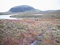
Duncolm in the heart of the Kilpatrick Hills with Lily Loch at its foot
-
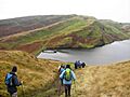
View from Cochno Hill over Greenside Reservoir to The Slacks
-
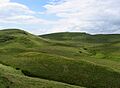
Fynloch Hill
-
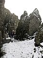
Walking through The Whangie in winter


