
Kyles of Bute facts for kids
Quick facts for kids Kyles of Bute National Scenic Area |
|
|---|---|

Caladh Harbour, Kyles of Bute. Taken in the anchorage behind Eilean Dubh. The Isle of Bute can be seen in the distance.
|
|

Kyles of Bute National Scenic Area
Location in Argyll and Bute
|
|
| Location | Argyll and Bute, Scotland |
| Area | 57.4 km2 (22.2 sq mi) |
| Established | 1981 |
| Governing body | NatureScot |
The Kyles of Bute (which means "the narrow straits of Bute" in Scottish Gaelic) is a narrow sea channel. It separates the northern part of the Isle of Bute from the Cowal peninsula on the Scottish mainland. This beautiful area is in Argyll and Bute, Scotland. The hills around the Kyles are covered in trees, with rocky tops and open moorland areas.
The Kyles are divided into two main parts: the East Kyle and the West Kyle. The East Kyle goes from Rothesay Bay northwest towards Loch Riddon. Here, you'll find small islands like the Burnt Islands and Eilean Dubh. The West Kyle then turns southwest, passing the village of Tighnabruaich and leading out to the Sound of Bute. This whole area is so special that it's called a National Scenic Area.
The local Shinty team, Kyles Athletic, is named after this famous waterway.
Contents
Getting Around the Kyles
The narrowest part of the Kyles is only about 300 meters wide. A short ferry ride connects Rhubodach on Bute to Colintraive on the mainland. This Calmac ferry crossing takes just 5 minutes and runs very often throughout the day. The ferry used for this route is called the MV Loch Dunvegan. Because the crossing is so short, people have sometimes talked about building a bridge instead of using a ferry.
Roads also follow the Kyles. The A8003 road runs high above the West Kyle, giving great views. On the mainland side of the East Kyle, the A886 road also runs above the shore. A smaller road, the B866 road, stays closer to the water near Loch Riddon. These roads meet near Colintraive. From there, the A886 continues across the ferry to the east side of Bute, heading towards Rothesay.
Fun Things to Do in the Kyles
The Kyles of Bute have been a popular spot for visitors for a long time. In the past, many people would take a trip "doon the watter" (down the water) on a Clyde steamer. Today, you can still experience this on the PS Waverley. This is the last sea-going paddle steamer in the world! It offers summer trips through the Kyles.
The Kyles are also a favorite place for yachting. There are many calm spots where boats can anchor safely.
If you enjoy walking, there are two great paths. The Cowal Way follows the shoreline of the West Kyle. The West Island Way on the Isle of Bute also has a section along the East Kyle. Both of these are part of Scotland's Great Trails, which are special long-distance paths.
The Kyles are part of an area known as "Argyll's Secret Coast," which is promoted for tourism.
Protecting the Kyles' Beauty
The Kyles of Bute is a designated National Scenic Area. Scotland has forty such areas. They are chosen because they have amazing scenery that needs to be protected from building projects that might spoil it. This special area covers about 57 square kilometers. Most of it is land, but it also includes about 10 square kilometers of sea. It covers parts of Bute and the Cowal peninsula, including the area around Loch Riddon.
Many bird species can be seen here regularly. These include eider ducks, oystercatchers, and herons.
One of the Burnt Islands, called Eilean Buidhe, has the remains of an old circular fort. Another island, Eilean Dearg in Loch Riddon, once had a Medieval castle. This castle was destroyed during a battle in 1685.
Who Owns the Land?

Much of the land around the Kyles has been owned by the same families for a long time. The Mount Stuart Trust owns the eastern shores of the East Kyle and most of the Isle of Bute. This trust is connected to the family of the Marquess of Bute.
The Rhubodach estate on Bute, which includes the western shoreline of the East Kyle, was once owned by the famous actor Lord Attenborough. In 2011, this land was bought by the Bute Community Land Company. This is a charity formed by people living on the island, showing how much the community cares about their local area.
A special viewpoint on the A8003 road, which offers amazing views of the Kyles, is looked after by the National Trust for Scotland.
Images for kids
-
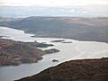
Kyles of Bute
-
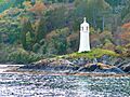
Caladh harbour light
-
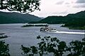
Burnt Islands Kyles of Bute
-
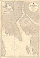
Admiralty Chart No 1906 Kyles of Bute and Inchmarnock Water

.jpg)


