Isle of Bute facts for kids
| Gaelic name | Eilean Bhòid or An t-Eilean Bòdach |
|---|---|
| Norse name | Bót |
| Meaning of name | Uncertain |
| OS grid reference | NS065651 |
| Coordinates | 55°49′26″N 05°06′39″W / 55.82389°N 5.11083°W |
| Physical geography | |
| Island group | Firth of Clyde |
| Area | 12,217 ha (47.17 sq mi) |
| Area rank | 13 |
| Highest elevation | Windy Hill, 278 m (912 ft) |
| Administration | |
| Sovereign state | United Kingdom |
| Country | Scotland |
| Council area | Argyll and Bute |
| Demographics | |
| Population | 6,498 |
| Population density | 53.19/km2 (137.8/sq mi) |
| Largest settlement | Rothesay |
The Isle of Bute, often just called Bute, is a beautiful island in the Firth of Clyde in Scotland, United Kingdom. It's known for its stunning landscapes and rich history. A special line called the Highland Boundary Fault divides the island into two different areas: highlands and lowlands.
Bute used to be part of a larger area called the County of Bute. Now, it's part of the council area of Argyll and Bute. In 2011, about 6,498 people lived on Bute. This number was a bit lower than in 2001.
Contents
What's in a Name?
The name "Bute" has a bit of a mystery around it. No one is completely sure where it came from! Some experts think it might come from an old Irish word, bót, which means "fire." This could be because people used to light signal fires on the island.
During the time of the Norsemen (Vikings), the island might have been called Bót. Another idea is that the name comes from a word meaning "corn" or "victory." There's also a thought it might be linked to Saint Brendan or his monastic cell.
The island was also known as Rothesay during the Viking era. This name might refer to a person named Roth or Roderick. The word ey in Old Norse means "island." The main town on Bute later took this name. Its Gaelic name is Baile Bhòid, which means "town of Bute."
Exploring Bute's Geography
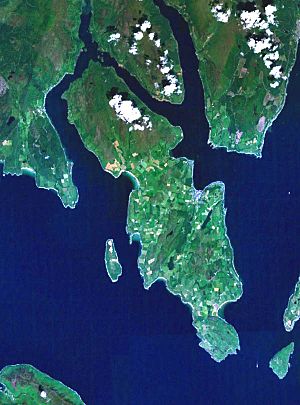
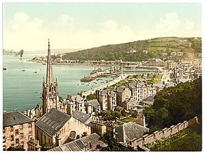
Bute is located in the Firth of Clyde. The main town on the island is Rothesay. You can reach Rothesay by ferry from the mainland. North of Rothesay is the village of Port Bannatyne. Other small villages on the island include Ascog, Kilchattan Bay, Kerrycroy, and Kingarth.
The middle of the island is hilly but not mountainous. You'll find forests of conifer trees and some wild land, especially in the north. The highest point on Bute is Windy Hill, which is 278 meters (912 feet) tall. Most of the farmed land is in the center of the island. The roughest parts of Bute are in the far south, around Glen Callum. Loch Fad is the biggest freshwater lake on Bute. It runs along the island's main fault line.
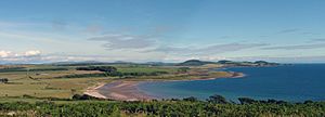
The western side of Bute is famous for its beautiful beaches. From these beaches, you can see amazing views across the Sound of Bute. You can also spot the Isle of Arran and Bute's smaller island, Inchmarnock. Small villages on the west side include Straad and Kildavanan.
In the north, the Kyles of Bute separates Bute from the Cowal peninsula. This northern part of the island has fewer people living there. A smaller ferry connects the island at Rhubodach to the mainland at Colintraive. This ferry ride is very short, less than 300 meters (328 yards). It only takes a few minutes, but it's a popular route for tourists. Many visitors enjoy the scenic drive to the island this way.
The northern part of Bute is part of the Kyles of Bute National Scenic Area. This is one of 40 such special areas in Scotland.
Bute's Rocky Foundations
Bute sits right on the edge of two major parts of Scotland. The Highland Boundary Fault cuts through the island from northeast to southwest. This fault line runs between Rothesay Bay and Scalpsie Bay.
North of this line, you'll find older, harder rocks. These rocks are mostly changed sandstones and mudstones. South of the fault, the rocks are younger. They include conglomerates, sandstones, and mudstones. You can also find some lava and tuff rocks, especially north of Ascog and near Kilchattan Bay.
The island also has many thin, flat rock formations called dykes. These formed when molten rock pushed its way into cracks in the existing rocks. You can also see raised beaches along most of Bute's coast. These are old shorelines that are now higher than the current sea level. They show how the land has risen over time.
A Look Back at Bute's History
Early Times on Bute
People have lived on Bute for a very long time. One ancient piece of jewelry, the Queen of the Inch necklace, was found here. It's made of jet and is about 4,000 years old!
Later, Gaelic people settled on the island. Bute then came under the control of the Norsemen (Vikings). It became part of the Kingdom of the Isles, which was ruled by a powerful family called the Crovan dynasty. In the 12th century, King David I gave Bute to Somerled, a powerful Scottish lord.
Around the 13th century, the island seems to have come into the hands of the Steward of Scotland family. This happened during a time when Somerled's descendants were fighting among themselves.
During the 1200s, Norway tried twice to take back control of the islands. Rothesay Castle was captured by Norwegian-backed forces in 1230 and again in 1263. But in 1266, the Norwegian king, Magnus VI, gave up the Kingdom of the Isles to the Scottish king, Alexander III. This was part of a deal called the Treaty of Perth. Alexander Stewart, a Scottish military leader, was rewarded by the king. He was confirmed as the owner of Bute and Arran.
Bute Under Scottish Rule
In 1549, a writer named Dean Monro described Bute as "very fertile ground." He mentioned two castles: the round Rothesay Castle and the castle of Kames. He also noted that the island had two churches and two chapels.
Under Scottish rule, Bute and Arran were managed together. The Steward of Scotland family became very important. One of their descendants, Robert, became King of Scotland. His son later created the title Duke of Rothesay for the heir apparent to the throne. This title is still used today for the eldest son of the British monarch.
In the 17th century, there were sad cases of witchcraft accusations on Bute. In 1630, some women confessed to witchcraft and died in Rothesay Castle. More accusations happened later, especially during the Great Scottish Witch Hunt of 1661–62. At least four women from Bute were executed during this time.
Later, in 1746, old local powers were removed. Then, in 1889, Bute and Arran officially became the County of Bute. More recently, Bute became part of the larger Argyll and Bute council area.
Bute in World War II
Bute played a big part during World War II. It was especially important for naval operations. A ship called HMS Cyclops was based in Rothesay Bay. It was a support ship for submarines.
A few miles north, in Port Bannatyne, a large hotel was used as the headquarters for special midget submarine (X-craft) operations. This place, renamed HMS Varbel, was where the secret plan to attack the German battleship Tirpitz was created. Much of the training for these X-craft submariners happened in the waters around Bute.
Many Polish soldiers and officers also stayed on Bute during the war. It was officially a military camp for the Polish Armed Forces in the West.
Bute in the 21st Century
In April 2019, large wildfires broke out in the north of the island. They affected a big area of moorland and forests.
In 2015, Bute welcomed about 100 Syrians who were seeking refuge. This made Bute one of the places in the UK that took in the most refugees compared to its population. The local council chose Bute because it had available housing and was close to medical support. These new residents have started successful businesses, like bakeries and takeaways, adding to the island's community.
In 2019, The Buteman, the island's weekly newspaper, closed after 165 years. This was due to fewer people reading it. A new newspaper, the Isle of Bute News, now covers island news.
Getting Around Bute
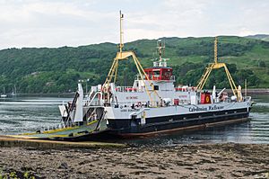
You can reach Bute from the Scottish mainland by two Caledonian MacBrayne ferries:
In the summer, the old paddle steamer Waverley sometimes visits Rothesay. It offers regular cruises. However, since 2019, the Waverley has been out of service due to a boiler problem.
There's a regular bus service along the eastern coast road. There's also a daily bus that connects the island to Argyll and the western Highlands. Many tourists use Bute as a stopover when traveling from Glasgow to western Scotland. In summer, an open-top bus offers tours around the island.
The main ferry leaves from Wemyss Bay. This village is on the A78 road, which runs between Glasgow and Ayr. Wemyss Bay has a train connection to Glasgow Central station. Glasgow Prestwick Airport is also connected to Wemyss Bay by a fast bus service.
You can even take a seaplane from Glasgow Pacific Quay to Port Bannatyne Marina. The flight takes only 17 minutes!
Learning on Bute
The island has one secondary school, Rothesay Academy. It moved to a new building in 2007, sharing a campus with Rothesay Primary. Rothesay Primary is the largest of the island's three primary schools. The smallest is North Bute Primary in Port Bannatyne, with about 50 students. The third primary school, St Andrews Primary, is a Catholic School. It is linked to St Andrew's Church, the only Catholic church on the island.
Sports and Activities
Bute offers many sports clubs and activities. There are three golf courses: Rothesay Golf Club, Kingarth Golf Club, and Port Bannatyne Golf Club. The Bute Shinty Club is the most successful sports club on the island. They play shinty at the highest level. In 2006, they won promotion to the Premier League.
The local amateur football team is called the Brandanes. The junior team is the Brandane Bulls. Bute also has places for fishing, rugby, tennis, bowls, and cricket. You can also play Pétanque in Port Bannatyne.
Port Bannatyne is the main place for sailing on Bute. It has two boatyards and a new marina. There's also a Bute Sailing School with its own yacht.
Bute's Economy
The Mount Stuart Trust owns a large amount of land on the island, about 28,000 acres. As of 2019, all the directors of the trust lived off the island.
Farming and tourism are the main jobs on Bute. Fishing and forestry are also important. Other local businesses include Port Bannatyne Marina and the Ardmaleish Boatbuilding Company. Bute Fabrics Ltd. is an international company that makes wool fabrics.
Things to See and Do
Amazing Buildings to See
The island has a ruined 12th-century chapel called St Blane's Chapel. It's on a site linked to Saint Catan and Saint Blane, who was born on Bute. Another ruined chapel, from the 6th century, is at St Ninian's Point.
Mount Stuart House is a very unusual and impressive mansion. It's often called one of the world's most amazing neo-Gothic houses. Many architecture students from Glasgow visit it. The house shows the interests of the third Marquess of Bute, who loved art, astrology, and religion. It has a marble chapel, beautiful stained glass, and many paintings. The house is open from Easter until October. It also has gardens with plants from all over the world and a visitor center.
In 2003, fashion designer Stella McCartney got married in the chapel at Mount Stuart House. This brought a lot of media attention. The house also hosts events like farmers' markets and Christmas markets. In 2016, a rare copy of Shakespeare's First Folio was found in the Mount Stuart House library.
The Pavilion is a building from the 1930s. It has a concert hall, workshops, and a café. It's known for its unique architecture. The building has been under renovation for several years and is expected to open soon.
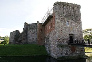
Rothesay Castle was built 800 years ago by the High Steward of Scotland. It's a fascinating place to explore.
Ascog Hall Fernery and Gardens is a restored Victorian house and glass-house. It has plants from all over the world, including a fern that might be over 1,000 years old!
The Old Post Office is a historic building that used to be a working post office. It now houses old postal items, some from before postage stamps existed.
Fun Places for Tourists
Loch Fad is a deep freshwater lake. It's full of pike and brown trout, and visitors can fish there. You can also rent boats.
Scalpsie Bay has a colony of over 200 seals on its beach. You can only reach them by walking across the fields. The island also has many herds of deer, lots of different birds, and some large hares. You might even see wild goats with big curled horns in the north of the island.
Port Bannatyne, a village in the north, is the main spot for sailing and sea-fishing. It has two boatyards and a marina for 200 boats. During World War II, X-Class midget submarines were based in Kames Bay. There is a memorial there for those who died in the war. Port Bannatyne Golf Club is famous for the great views from its course.
The road from Port Bannatyne goes about 7 miles (11 km) along the shore of the Kyles of Bute. It leads to the small ferry that crosses to Colintraive on the mainland.
Things to Do in Rothesay
The 1920s Winter Gardens, now called the "Discovery Centre," is near the Rothesay Pier. It has a small cinema and a tourist information office. Close by are the historic Victorian toilets.
Bute hosts various music, folk, and poetry festivals. There are also many walking trails and new cycling routes to enjoy.
Bute's Heritage
You can find some ancient Bronze Age stone circles on Bute. There's also an Iron Age fortified village. The island has early Christian remains, including St. Blane's Chapel. The Bute Museum tells the story of the island's history and is located behind Rothesay Castle.
Walking Trails
The West Island Way is a special long-distance walking path. It opened in September 2000 as part of Bute's millennium celebrations. It was the first marked long-distance route on a Scottish island. The path is 48 kilometers (30 miles) long. It runs from Kilchattan Bay in the south to Port Bannatyne in the north, with Rothesay in the middle.
See also
 In Spanish: Isla de Bute para niños
 | Jewel Prestage |
 | Ella Baker |
 | Fannie Lou Hamer |


