
County of Bute facts for kids
Quick facts for kids
Bute
|
|
|---|---|
 |
|
| Country | Scotland |
| County town | Rothesay |
| Area | |
| • Total | 225 sq mi (583 km2) |
| Ranked 30th of 34 | |
| Chapman code |
BUT
|
The County of Bute (Scottish Gaelic: Siorrachd Bhòid), also known as Buteshire, is a historic county and registration county in Scotland. It's a special area that has been used for official records for a long time.
This county includes several islands in the Firth of Clyde. This is a large bay located between the areas of Argyll and Ayrshire. The main islands are Bute, Arran, Great Cumbrae, and Little Cumbrae. The main town, called the county town, is Rothesay. It is found on the Isle of Bute. Buteshire had its own elected local government, called a county council, from 1890 until 1975.
Contents
History of Buteshire
Buteshire was first created as a "shire" around the year 1385 by King Robert II. A shire was an area managed by a "sheriff," who was like a local judge and administrator. Before this, the islands in the Firth of Clyde were not part of any shire. The first Sheriff of Bute was the king's son, John Stewart. This job was then passed down through his family. They later became known as the Earls of Bute in 1703.
Changes in Local Government
In 1746, a law called the Heritable Jurisdictions (Scotland) Act 1746 stopped sheriffs from passing their jobs down through their families. After this, sheriffs were chosen by the king or queen. A new law in 1747 made Buteshire share a sheriff with the nearby area of Argyll.
In 1667, groups called "Commissioners of Supply" were set up in each shire. These groups were the main way local areas were managed. They continued until 1890. That's when elected county councils were created by the Local Government (Scotland) Act 1889. These new councils took over most of the jobs from the Commissioners of Supply.
The Bute County Council was based at the Rothesay Town Hall and County Buildings in Rothesay. This building was built in 1835. It was used by the Rothesay Town Council and the Commissioners of Supply. It also served as the courthouse for Buteshire.
Buteshire Today
Buteshire stopped being used for local government in 1975. This happened because of the Local Government (Scotland) Act 1973. This law changed how Scotland was divided for local government. The old counties were replaced with larger "regions" and smaller "districts." Buteshire became part of the Strathclyde region. The Isle of Bute was placed in the Argyll and Bute district. The Isle of Arran and the Cumbraes were placed in the Cunninghame district.
In 1996, the Strathclyde region was also removed. The regions and districts were replaced by single "council areas." Argyll and Bute became a council area. Cunninghame was renamed to become the North Ayrshire council area.
Even though Buteshire is no longer used for local government, its old boundaries are still important. They are used for some official purposes, especially for keeping land records. This means it is still a registration county.
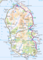
Geography of the Islands

Buteshire is made up of two main islands in the Firth of Clyde. These islands are separated by the Sound of Bute.
Arran and its Smaller Islands
The first main island is Arran. It also includes much smaller islands nearby. These are Holy Island, Hamilton Isle, and Pladda. Arran is the 7th largest island in Scotland. It is a very popular place for tourists to visit. People often call it 'Scotland in miniature.' This is because it has many different types of scenery and land features.
Arran looks a bit like a peanut. It is flatter in the south. However, it becomes more mountainous in the north. The tallest mountain in Buteshire is on Arran. It is called Goat Fell, and it is 874 metres (2,866 feet) high. Arran is separated from the Kintyre peninsula by a narrow stretch of water called Kilbrannan Sound.
Bute and the Cumbraes
The other main island is Bute. It is generally flatter than Arran, but it does have some hills, especially in the north. A small island called Inchmarnock is located off Bute's west coast. Bute is separated from the Cowal peninsula by the very narrow Kyles of Bute. Several lakes, called lochs, are found in the middle of Bute. The most famous ones are Loch Fad, Loch Quien, and Loch Ascog.
The Cumbraes are also part of Buteshire. They are located between Bute and Ayrshire on the mainland. The Cumbraes include Great Cumbrae and Little Cumbrae. There are also tiny islets like The Eileans, Broad Islands, Castle Island, and Trail Island.
Getting Around: Transport

Traveling to and from the islands of Buteshire mainly involves ferries. Bute is connected to Wemyss Bay on the Scottish mainland by a ferry. Another ferry connects Bute to the Cowal peninsula from the north-east side of the island.
On Bute, a main road runs along the east coast. It also goes around the southern part of the island. The northern part of Bute has fewer roads. You can mostly explore it by walking or cycling.
Arran is also connected to the Scottish mainland by ferries. From the north of Arran, you can take a ferry to Tarbert and Claonaig in Kintyre. From Rothesay, ferries go to Ardrossan in Ayrshire. They also go to Campbeltown further down the Kintyre peninsula. A road goes all the way around the edge of Arran. There is also a smaller road that cuts across the island from east to west. Finally, a ferry connects Great Cumbrae to Largs in Ayrshire.
Parliamentary Constituencies

For a long time, Buteshire had its own special area for electing a Member of Parliament (MP). This MP would represent the people of Buteshire in the House of Commons. This was part of the Parliament of Great Britain from 1708 to 1800. Then it became part of the Parliament of the United Kingdom from 1801 to 1918.
How Representation Changed
Between 1708 and 1832, Buteshire and Caithness took turns electing an MP. One county would elect an MP for one parliament, and then the other county would elect an MP for the next. From 1832 to 1918, Buteshire was a separate area. It elected an MP for every parliament. In 1841, the population of Buteshire was 15,740 people.
In 1918, the Buteshire area for elections was combined with the Ayrshire North constituency. This created a new area called the Bute and Northern Ayrshire constituency. This new area crossed the old boundaries of Bute and Ayrshire.
In 1983, the Bute and Northern Ayrshire area was divided again. This happened eight years after the old Scottish counties were removed for local government. It was split between the Argyll and Bute constituency and the Cunninghame North constituency.
In 2005, both of these areas were made larger. The name "Argyll and Bute" stayed the same. The larger Cunninghame North was renamed North Ayrshire and Arran.
Today, there are also similar areas for the Scottish Parliament. They are called Argyll and Bute and Cunninghame North.
Towns and Villages
Here are some of the towns and villages you can find in Buteshire:
On Arran
- Blackwaterfoot
- Brodick
- Catacol
- Cladach
- Corrie
- Corriegills, Arran
- Dippen
- Kildonan
- Kilmory
- Kings Cross, Arran
- Lagg
- Lamlash
- Lochranza
- Machrie
- Pirnmill
- Sannox
- Shiskine
- Sliddery
- Whitefarland
- Whiting Bay
On Bute
On The Cumbraes
Images for kids
-
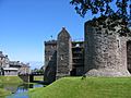
Rothesay Castle, Bute, with the 16th century forework in the centre, and the 13th century "Pigeon Tower" on the right
-
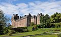
Brodick Castle, Arran
-
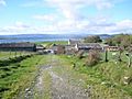
Kilmory Castle is incorporated into Meikle Kilmory Farm, Bute
-
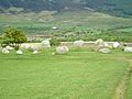
Machrie Moor Stone Circle, Arran
-
Isle of Arran
-
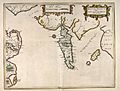
Blaeu Atlas. Arania
-
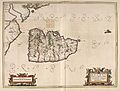
Blaeu Atlas. Buthe Insula
-
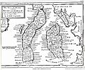
Shire of Bute. by H. Moll
-
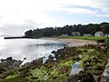
Kerrycroy Bay, Bute
-
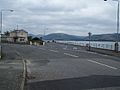
Ardbeg, Bute
-
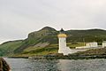
Lighthouse on Holy Island
-
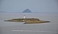
The isle of Pladda as seen from Arran, with Ailsa Craig in the distance
-
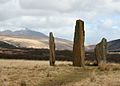
Machrie Moor Standing Stones on Arran
-
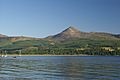
Goat Fell on Arran, the highest point of Buteshire
.jpg)


See also
