
Kintyre facts for kids
Quick facts for kids Kintyre |
|
|---|---|

Kintyre highlighted within Argyll
|
|
| Location | Argyll and Bute, Scotland, United Kingdom |
| Official name: Kintyre Goose Roosts | |
| Designated: | 28 October 1998 |
| Reference #: | 966 |
Kintyre (Scottish Gaelic: Cinn Tìre) is a long, narrow piece of land in western Scotland. It is a peninsula, meaning it is almost surrounded by water but connected to the mainland on one side. Kintyre stretches for about 30 miles (48 km) from the Mull of Kintyre in the south to East and West Loch Tarbert in the north. The area just north of Kintyre is called Knapdale.
Kintyre is never wider than 11 miles (18 km) from one coast to the other. At its narrowest point, where it joins Knapdale, it is less than two miles wide. The eastern side of Kintyre faces the Kilbrannan Sound. The middle of the peninsula has hilly moorland, with the highest point being Beinn an Tuirc at 454 meters (1,490 ft). The coastal areas are very fertile and good for farming.
People have lived in Kintyre for a very long time. Early settlers included the Scots who came from Ulster (in Ireland) and the Vikings (also known as Norsemen). These groups conquered and settled the area around 1,000 years ago.
The main town in Kintyre is Campbeltown. It has been an important town since the mid-1700s. The local economy has traditionally relied on fishing and farming. Campbeltown is also famous for making some of the world's best single malt whisky, including the award-winning Springbank.
Contents
History of Kintyre
Ancient Times

Kintyre has many old sites from the Stone Age. For example, at Ballochroy, there are three large standing stones called megaliths. They line up with features on the island of Jura. There are also several ancient burial mounds, called cairns, at Blasthill.
From the Iron Age, you can find impressive forts like Dun Skeig, a Celtic hillfort at the northern end of Kintyre. Another stone fort from the 2nd century BC is at Kildonan.
Kintyre is only 12 miles (19 km) from Ulster in Ireland. People have traveled between these two places for thousands of years. This is shown by Stone Age tools found in Kintyre that are typical of Antrim in Ulster.
In the early first millennium, people called Gaels from Ireland settled in Kintyre. They created a kingdom called Dál Riata. This kingdom was divided into areas controlled by different family groups. The most powerful group, the Cenél nGabráin, ruled over Kintyre and nearby areas.
This kingdom grew for a few centuries. It was also a starting point for spreading Christianity to mainland Scotland. Sanda, an island near Kintyre, is linked to Ninian, an early missionary. He is said to have built a chapel there in the 5th century. In 563, Columba visited Kintyre before going to Iona. From Iona, he helped spread Christianity throughout the region.
Viking Rule
Later, Norse Vikings invaded and took over the area. They created their own kingdom, which included many islands to the north and west of Scotland. This kingdom was called the Kingdom of Mann and the Isles. The mainland area, which used to be Dal Riata, became known as Argyle (now Argyll), meaning the "Gaelic coast."

In 1093, Magnus Barefoot, the King of Norway, wanted to control these islands. Malcolm, the King of Scotland, agreed that Magnus could rule any western lands he could sail around. Magnus used this agreement cleverly. He had his boat dragged across the narrow strip of land at Tarbert. He sat in the boat while it was pulled. This way, he claimed Kintyre as an "island," along with Arran and Bute.
A few years later, in 1098, the new Scottish king, Edgar, gave Magnus all authority over the islands, Kintyre, and Knapdale. This was done to avoid more conflict with Norway.
In the mid-12th century, a leader named Somerled successfully rebelled against Norway. He made the Kingdom of the Isles independent. After his death, his grandsons divided the lands. Donald, Somerled's grandson, gained control of Kintyre, Knapdale, Islay, and Jura. Donald's father, Reginald, founded Saddell Abbey in 1207.
In the mid-13th century, there was more fighting between Norway and Scotland. After the Battle of Largs, the Norwegian king died. In 1266, his successor signed the Treaty of Perth. This treaty gave Scotland control over the islands and Kintyre in exchange for a large sum of money.
Scottish Control
In 1293, King John Balliol created the role of sheriff for Kintyre. A sheriff was a local official who enforced laws. Later, Robert the Bruce fought for the Scottish throne. The MacDonalds, a powerful family descended from Somerled, supported Robert the Bruce. When he won, he gave them more land, including parts of Kintyre.
The head of the MacDonald family married the heir of another powerful family, creating the Lordship of the Isles. This powerful lordship controlled many western islands and parts of the mainland for over a century. Later, the Lord of the Isles gave Kintyre and Knapdale back to the Scottish king as part of a marriage agreement.
In 1462, John, the Lord of the Isles at the time, secretly planned with the English king to conquer Scotland. When this was discovered in 1475, he had to give up Ross, Kintyre, and Knapdale to Scotland.
The Campbells and Modern Times

Around 1481, the sheriffdom of Kintyre became Tarbertshire, named after Tarbert at the northern end of Kintyre. The Scottish king James IV of Scotland appointed Archibald Campbell as governor of Tarbert Castle. This gave the Campbells more power in the area.
In the 1600s, the MacDonalds and the Campbells often disagreed. In 1607, King James VI ordered the MacDonalds' lands in Kintyre to be given to Archibald Campbell. The Campbells became very powerful. The local court moved to Inveraray, which was closer to the Campbells' main base.
Archibald's son wanted to create a large settlement in southern Kintyre. He planned to bring loyal Presbyterian people from Lowland Scotland to live there. This was meant to change the local population and reduce resistance to religious reforms. Under his son, Archibald, this settlement became Campbeltown. These actions also slowly changed the local Gaelic culture.
In 1746, old noble powers were removed by law. Kintyre became part of the County of Argyll. Today, it is part of the larger region of Argyll and Bute.
Towns and Villages
Kintyre is home to many towns and villages. Here are some of them:
- Achinhoan
- Bellochantuy
- Campbeltown
- Carradale
- Clachan
- Claonaig
- Dippen
- Drumlemble
- Glenbarr
- Grogport
- Kennacraig
- Kilchenzie
- Killean
- Machrihanish
- Muasdale
- Peninver
- Saddell
- Skipness
- Southend
- Stewarton
- Tarbert
- Tayinloan
- Torrisdale
- West Tarbert
- Whitehouse
Getting Around Kintyre
You can find information about all public transport in Scotland at Traveline Scotland.
Bus and Coach Services
- Long-distance coaches to and from Glasgow are run by West Coast Motors for Scottish Citylink.
- Bus services within the Kintyre peninsula are run by West Coast Motors.
Flights
- Flights are available between Glasgow International Airport and Campbeltown Airport.
Ferry Services
- Caledonian MacBrayne operates ferries on these routes:
- Claonaig - Lochranza (in summer)
- Kennacraig - Islay
- Tarbert - Lochranza (in winter)
- Tarbert - Portavadie
- Tayinloan - Gigha
- Campbeltown- Ardrossan (in summer)
- Kintyre Express operates ferries on these routes:
Railways
There are no railways in use in Kintyre today. From 1876 to 1931, the Campbeltown and Machrihanish Light Railway operated. It was first built to transport coal.
Places to Visit
Kintyre has many interesting historic sites to explore.
Historic Buildings and Churches
- Clachan Church - features carved medieval grave slabs.
- Kilchenzie church - an old church.
- Kilchousland Chapel - located near Peninver.
- Kilcomkill, Southend - home to St Columba's Chapel and carved grave slabs. You can also see "St. Columba's footprints" nearby.
- Killean - St. John's Church - considered the most important medieval church in Kintyre, with carved grave slabs.
- 18th-century Killean and Kilchenzie Church - located at A'Chleit.
- Saddell Abbey - a historic abbey.
- Saddell Castle - a castle with a rich history.
- Skipness Castle - a well-preserved castle.
- Tarbert Castle - the remains of a historic castle.
Ancient Sites
- Avinagillan standing stone - an ancient standing stone.
- Ballochroy standing stones - a group of ancient standing stones.
- Beacharr standing stone - located near Tayinloan.
- Corriechrevie cairn - an intact ancient burial mound.
- Dun Skeig - Iron Age forts near Clachan.
- Kildonan galleried dun - an ancient stone fort.
- A crag near the chapel of Keil and St. Columba's Well has two carved footprints. This is where St. Columba is said to have first arrived in Scotland.
Famous Song
The most well-known song about Kintyre is "Mull of Kintyre" by Wings. Paul McCartney owns a farm in Kintyre and wrote the song as a tribute to the beautiful peninsula. It became a huge hit in the United Kingdom in 1977.
Images for kids
-
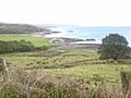
The north-eastern coast of the Kintyre peninsula looking northward to Skipness and the Sound of Bute
-
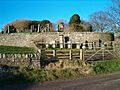
Skipness Castle
-
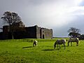
Ruins of the old church at Kilchenzie with beehives below
-
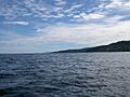
Kintyre Peninsula visible from Torrisdale Bay


See also
 In Spanish: Kintyre para niños
