Campbeltown Airport facts for kids
Quick facts for kids
Campbeltown Airport
Port-adhair Cheann Loch Chille Chille Chiarain
RAF Machrihanish
MoD Machrihanish
|
|||||||||||
|---|---|---|---|---|---|---|---|---|---|---|---|
 |
|||||||||||
| Summary | |||||||||||
| Airport type | Public | ||||||||||
| Owner | Machrihanish Airbase Community Company (MACC) | ||||||||||
| Operator | HIAL (public airport) MACC Developments Ltd. (former airbase) |
||||||||||
| Serves | Campbeltown and Isle of Arran | ||||||||||
| Location | Machrihanish, Argyll and Bute | ||||||||||
| Elevation AMSL | 42 ft / 13 m | ||||||||||
| Coordinates | 55°26′15″N 005°41′17″W / 55.43750°N 5.68806°W | ||||||||||
| Website | Campbeltown Airport | ||||||||||
| Map | |||||||||||
| Runway | |||||||||||
|
|||||||||||
| Statistics (2022) | |||||||||||
|
|||||||||||
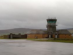
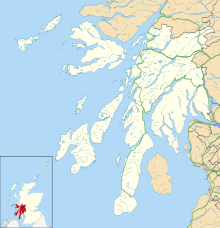
Campbeltown Airport (which is Port-adhair Cheann Loch Chille Chiarain in Scottish Gaelic) is an airport in Scotland. It is found at Machrihanish, about 3 miles (5 km) west of Campbeltown. This area is near the tip of the Kintyre peninsula in Argyll and Bute.
The airport is known by its airport codes: CAL (IATA) and EGEC (ICAO). It is a public airport, meaning anyone can use it for flights.
Contents
History of Campbeltown Airport
Campbeltown Airport used to be a military airbase. It was called RAF Machrihanish. This base was very important for different air forces.
Military Role and NATO
The airport hosted planes from the Royal Air Force. Other NATO air forces also used it. Even the United States Marine Corps had squadrons here.
The airport's location was very strategic. It is close to the Irish Sea. This made it a good place to guard the entrance to the Firth of Clyde. US nuclear submarines were based there in the past. Today, Royal Navy Trident missile submarines are still based nearby.
Becoming a Public Airport
The United States Navy gave the airfield back to the UK Ministry of Defence (MoD) in 1995. This marked the end of its time as a NATO base. It had been a NATO facility since 1960.
In May 2012, the airbase was sold. It was bought by the Machrihanish Airbase Community Company (MACC). Now, two-thirds of the runway is leased. This part is used by Highlands and Islands Airports for Campbeltown Airport.
Scotland's Longest Runway
The main runway at Campbeltown Airport is very long. It measures about 3,049 meters (10,003 feet). This makes it the longest runway at any public airport in Scotland. It was built between 1960 and 1962. This was part of a big project to rebuild the airport for its NATO role.
What the Airport Does Today
Campbeltown Airport has a special licence. It is called a CAA Ordinary Licence (Number P808). This licence allows the airport to have flights for passengers. It also allows flying lessons. Highlands & Islands Airports Limited manages this licence.
Airlines and Destinations
Only one airline currently flies regularly from Campbeltown Airport.
- Loganair flies to Glasgow.
Airport Facts and Figures
Important Event
On March 15, 2005, a Loganair aircraft crashed. It was flying as an air ambulance. The plane was about 7.7 nautical miles (14.3 km) from Campbeltown Airport. Both people on board, the pilot and a paramedic, sadly passed away.
The aircraft was a Britten-Norman BN-2 Islander. It was trying to land at Campbeltown in low clouds. The air ambulance was going to pick up a patient. The patient needed to be taken to Glasgow for surgery.
 | Mary Eliza Mahoney |
 | Susie King Taylor |
 | Ida Gray |
 | Eliza Ann Grier |


