
Knapdale facts for kids
Quick facts for kids Knapdale |
|
|---|---|
 Keills Chapel with cross |
|
 |
|
| Population | 2,836 (2011) |
| OS grid reference | NR700747 |
| • London | 370 mi (600 km) |
| Council area |
|
| Lieutenancy area |
|
| Country | Scotland |
| Sovereign state | United Kingdom |
| EU Parliament | Scotland |
| UK Parliament |
|
| Scottish Parliament | |
Knapdale is a beautiful rural area in Argyll and Bute, a part of the Scottish Highlands. It sits next to Kintyre in the south. The Crinan Canal separates Knapdale from the rest of Argyll to the north.
Knapdale is surrounded by water on its east and west sides. Loch Fyne is to the east, and the Sound of Jura is to the west. A sea loch called West Loch Tarbert almost cuts it off from Kintyre in the south. The name Knapdale comes from two Gaelic words: Cnap, meaning hill, and Dall, meaning field.
This area is so special that it's part of the Knapdale National Scenic Area. This is one of Scotland's 40 national scenic areas. These places are chosen because they have amazing views and need to be protected. The Knapdale National Scenic Area covers a huge space, including both land and sea.
Contents
Exploring Knapdale's Geography
| Knapdale National Scenic Area | |
|---|---|

Loch Arail in late summer, with heather in bloom
|
|
| Location | Argyll and Bute, Scotland |
| Area | 328 km2 (127 sq mi) |
| Established | 1981 |
| Governing body | NatureScot |
The main road, the A83, runs along the eastern coast of Knapdale. It connects Tarbert and Lochgilphead. Another road, the B8024, also links these places. It takes a longer route along the west coast of South Knapdale.
You can explore most of North Knapdale's western coast by car. The B8024 road is also part of Route 78 of the National Cycle Network. This route goes all the way from Inverness to Campbeltown.
Knapdale's western coast has two deep sea lochs: Loch Sween and Loch Caolisport. The highest point in Knapdale is Stob Odhar, which is 562 meters (about 1,844 feet) tall. Two other hills, Cruach Lusach and Cnoc Reamhar, are known as Marilyns. This means they are hills with a certain height and a drop on all sides.
Towns and Villages in Knapdale
Here are some of the places you can find in Knapdale:
- Achahoish
- Achnamara
- Ardrishaig
- Crinan
- Kilberry
- Kilmory
- Tayvallich
People of Knapdale
In 2011, about 2,836 people lived in Knapdale. This number has stayed fairly steady over the years. In 1991, there were 2,704 people living here.
Historically, the population in North Knapdale slowly went down from the 1800s to the mid-1900s. However, South Knapdale's population has been more stable, and even grew a little in the 19th century.
Knapdale's Rich History
Knapdale has a long and exciting history, with stories of ancient kingdoms and powerful rulers.
Ancient Gaels and Norse Vikings

Long ago, around 1,500 years ago, Gaelic people from Ireland came to this area. They created a kingdom called Dál Riata. Knapdale was part of this kingdom. The most powerful family, the Cenél nGabráin, ruled over Knapdale and nearby areas. Dunadd, the capital of Dál Riata, was just north of modern Knapdale.
This Gaelic kingdom was strong for a few centuries. But then, Norse Vikings invaded. They took over many islands and established their own kingdom, called the Kingdom of Mann and the Isles. The area of Dál Riata became known as Argyle, meaning the Gaelic coast.

In 1093, Magnus, the King of Norway, wanted to control these islands. The Scottish King, Malcolm, made a deal with him. Malcolm agreed that Magnus could rule any western lands he could sail around. Magnus was clever! He had his boat dragged across the narrow strip of land at Tarbert. He sat in the boat as it was pulled. This way, he claimed Kintyre and Knapdale as his own.
Later, in 1098, another Scottish King, Edgar, officially gave all the islands and the Kintyre peninsula (including Knapdale) to Magnus. This was to avoid a big war.
Knapdale in the Kingdom of the Isles

Around the mid-1100s, a powerful leader named Somerled took control of the Kingdom of the Isles. Knapdale was then owned by Suibhne, who gave his name to Castle Sween.
In 1262, there was a lot of tension between Norway and Scotland. The Scots made Suibhne's heir, Dubhghall, give up his lands, including Knapdale. In 1263, the Norwegian King, Hákon, invaded Scotland. But after Hákon died, Norway gave up its claim to the islands and Kintyre (including Knapdale) to Scotland in 1266, in exchange for a large sum of money. This was part of the Treaty of Perth.
Knapdale Becomes Part of Scotland
.jpg)
By the 1200s, Somerled's family had split into three main groups: the MacDougalls, MacRorys, and MacDonalds. When there was a fight over who should be the Scottish King, these families took different sides. When Robert de Bruys won, he gave the MacDougall lands to the MacDonalds.
The leader of the MacDonald family married the heir of the MacRory family. This brought all of Somerled's old kingdom under their control, creating the powerful Lord of the Isles. Later, the head of the MacDonalds divorced his wife and married Margaret, the daughter of Robert II, the Scottish King. King Robert gave Knapdale to his daughter as a gift when she married.
However, in 1462, John, who was then the Lord of the Isles, secretly planned with the English King to conquer Scotland. When this was discovered in 1475, John had to give up Ross, Kintyre, and Knapdale to Scotland. This made Knapdale officially part of Scotland.
Over time, the powerful Clan Campbell grew in the east and north. The local government for Knapdale moved closer to them. Eventually, in 1633, the sheriff (local law officer) for Knapdale became the sheriff of Argyll.
In 1746, old laws about local power were changed. Knapdale then became just the district we know today, south of Lochgilphead. In 1899, counties were officially created, and Knapdale became part of the County of Argyll.
Knapdale in Modern Times
Much of Knapdale is covered by Knapdale Forest, which was planted in the 1930s. During the 1930s, unemployed men from mining towns helped plant the forest. They lived in special camps. One camp in Knapdale, at Cairnbaan, was even used to hold enemy prisoners during the Second World War. Today, one of the old buildings from the camp is still used by Forestry and Land Scotland.
After some changes in the late 1900s, Knapdale is now part of the larger Argyll and Bute region.
Who Owns Knapdale?
Most of Knapdale is owned by Forestry and Land Scotland. This is a government agency that manages Scotland's forests and land.
There are also two large private estates near Loch Caolisport. The Ellary & Lochead Estate is on the north side of the loch. The Ormsary Estate is on the southern side and belongs to Sir William Lithgow, who is a Baronet and involved in Scottish shipbuilding.
An estate of 173 acres in the area belongs to Iain Coucher, a former chief executive of Network Rail. This property includes two islands in the Sound of Jura.
Amazing Historic Sites
Knapdale has many interesting old places to visit:
- The Chapel of Keills was built in the 1100s. It has almost 40 carved stones from early Christian and Medieval times. The most important is the eighth-century Keills Cross, which looks like crosses found on Iona.
- A grave-slab in the chapel has a carving of a clarsach, which is a type of harp. It looks like the Queen Mary Harp in the Museum of Scotland in Edinburgh. This suggests that these harps might have come from Knapdale.
- You can also find more old carved stones at Kilberry and at the 13th-century Kilmory Knap Chapel.
- Castle Sween, on the shores of Loch Sween, was built in the 1100s. It is one of the oldest stone castles on the Scottish mainland that we can be sure about its age.
Knapdale's Environment and Wildlife
Knapdale is home to some very special natural areas and wildlife.
Protected Areas
Four lochs in Knapdale are protected as a Special Protection Area. This is because they are important breeding grounds for black-throated divers, which are special birds.
Loch Sween is also a Nature Conservation Marine Protected Area. The inner part of the loch has unique habitats like maerl beds (a type of seaweed) and burrowed mud. These areas support creatures like the volcano worm. The loch also has one of Scotland’s most important groups of native oysters.
Taynish National Nature Reserve
Taynish National Nature Reserve is in North Knapdale, near the village of Tayvallich. This reserve covers most of the Taynish peninsula. The woodlands here are often called a 'temperate rainforest'. This is because they get a lot of rain and have a mild climate thanks to the Gulf Stream. NatureScot owns and manages Taynish, and it became a National Nature Reserve in 1977.
Beaver Reintroduction
In 2007, a project began to bring Eurasian beavers back to Knapdale. The first beavers were released in May 2009. This was a trial project run by the Scottish Wildlife Trust and the Royal Zoological Society of Scotland.
In 2016, the Scottish Government announced that beavers could stay in Scotland permanently. They are now a protected native species. Beavers are allowed to spread naturally from Knapdale. More beavers were released between 2017 and 2020 to help the population grow.
Images for kids
-
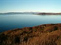
View from Knapdale towards Jura
-
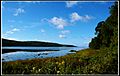
Loch Caolisport
-
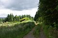
Forest track in Knapdale
-
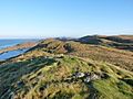
"Iainland"


