
River Don, Aberdeenshire facts for kids
Quick facts for kids River Don |
|
|---|---|

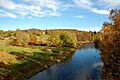
River Don and Castle Forbes near Alford.
|
|
| Country | Scotland |
| County | Aberdeenshire |
| Physical characteristics | |
| Main source | Ladder Hills |
| River mouth | Bridge of Don, Aberdeen 57°10′34″N 2°04′37″W / 57.1760°N 2.0770°W |
| Length | 131 km (81 mi) |
| Basin features | |
| Basin size | 1,312 km2 (507 sq mi) |
The River Don (Scottish Gaelic: Deathan) is a river in north-east Scotland. It starts high up in the Grampian Mountains and flows east. The river travels through Aberdeenshire before reaching the North Sea at Aberdeen.
Along its journey, the Don passes through towns like Alford, Kemnay, Inverurie, Kintore, and Dyce. Its most important smaller river, the River Ury, joins it near Inverurie.
Contents
Where the River Don Flows
The River Don begins in a flat, peaty area called Druim na Feithe. It starts near Glen Avon. The river then flows past old ice-age hills called moraines.
Several small streams join together to form the young Don. These include the Dhiver, Feith Bhait, and Cock Burn. Water from the north side of Brown Cow Hill flows into the Don. Water from other sides goes into different rivers like the River Spey or the Dee.
The Don takes a winding path eastwards. It flows past Corgarff Castle and through Strathdon. It also goes through the Howe of Alford. Finally, it reaches the North Sea just north of Old Aberdeen.
Many smaller rivers and burns feed into the Don. Some of the main ones are Conrie Water, Ernan Water, Water of Carvie, and the River Ury.
History of the River Don
People have known about the River Don for a very long time. Around 200 AD, a geographer named Ptolemy from Alexandria wrote about it. He called it Devona, which means 'goddess'. This name suggests that the river was once seen as a special, sacred place.
Near Kintore, not far from the Don, there is an old Roman Camp called Deers Den. This shows that Romans were in the area long ago.
In 1750, the lower part of the Don was changed by people. They dug a channel to guide it directly to the sea. This moved where the river met the sea further north.
How the River Flows
Scientists measure the water levels and flow of the River Don. They use special places called gauging stations. These measurements have been taken since 1969.
The lowest measuring station is at Parkhill, near Dyce. This station measures most of the river's water. It helps us understand how much water is in the river.
The highest water levels ever recorded were in January 2016. This was during a time of big floods in Great Britain and Ireland. The river rose very high. This caused flooding in many areas along the river. People had to leave their homes for safety. Areas like Port Elphinstone, Kintore, and Donside in Aberdeen were affected.
Economy and Fun
The area around Strathdon is popular with visitors. People come here to fish for salmon and trout. The region also has many beautiful castles and lovely scenery to enjoy.
Images for kids
-
River Don and Castle Forbes near Alford.
See also
 para niños") In Spanish: Río Don (Escocia) para niños
In Spanish: Río Don (Escocia) para niños
