
Angus, Scotland facts for kids
Quick facts for kids
Angus
Aonghas
|
|||||
|---|---|---|---|---|---|
 |
|||||
|
|||||
| Sovereign state | United Kingdom | ||||
| Country | Scotland | ||||
| Lieutenancy area | Angus | ||||
| Admin HQ | Forfar | ||||
| Government | |||||
| • Body | Angus Council | ||||
| Area | |||||
| • Total | 842 sq mi (2,182 km2) | ||||
| Area rank | Ranked 10th | ||||
| Population
(2020)
|
|||||
| • Total | 116,040 | ||||
| • Rank | Ranked 17th | ||||
| • Density | 137.74/sq mi (53.181/km2) | ||||
| GSS code | S12000041 | ||||
| ISO 3166 code | GB-ANS | ||||


Angus (which is Angus in Scots and Aonghas in Scottish Gaelic) is a special area in Scotland. It's one of the 32 local government council areas of Scotland. It's also a registration county and a lieutenancy area.
Angus shares its borders with Aberdeenshire, Dundee City, and Perth and Kinross. Important jobs in Angus include agriculture (farming) and fishing. A big company called GSK, which makes medicines, has a major office in Montrose.
Long ago, Angus was a province and then a sheriffdom and county. It was even called Forfarshire from the 1700s until 1928. Its old borders were with Kincardineshire to the north-east, Aberdeenshire to the north, and Perthshire to the west. To the south, it faced Fife across the Firth of Tay. These borders are mostly the same today, except Dundee is now its own separate council area.
Contents
Angus: A Look at Its Past
How Angus Got Its Name
The name "Angus" comes from an old Pictish king from the 700s. His name was Óengus.
Ancient Times in Angus
People have lived in the Angus area for a very long time. We know this from things found from the Neolithic period (New Stone Age). For example, at Douglasmuir, near Friockheim, archaeologists found evidence of an old enclosure. It was built around 3500 BC. We don't know exactly what it was for, but it might have been used for farming or special ceremonies.
There are also many discoveries from the Bronze Age here. Near West Newbigging, people found ancient burials with pottery, silver discs, and a gold armlet. From the Iron Age, we have souterrains (underground passages) at Warddykes cemetery and West Grange of Conan. Other famous examples are at Carlungie and Ardestie.
Medieval and Later History of Angus
Angus is linked to an old Pictish area called Circin. This area probably included Angus and the Mearns. The Picts were an ancient people who lived in Scotland. You can still see many sculptured stones from their time all over Angus. Some of the best collections are at Aberlemno, St Vigeans, Kirriemuir, and Monifieth.
Angus was first written about as a Scottish province in 937. This was when Dubacan, a leader of Angus, died in a big battle.
A very important event for Scotland happened in Angus. The Declaration of Arbroath was signed at Arbroath Abbey in 1320. This document declared Scotland's independence. Because of this, Angus is often called the "birthplace of Scotland."
Besides Arbroath Abbey, other famous historic places include Glamis Castle, the Arbroath Signal Tower museum, and the Bell Rock Lighthouse. The lighthouse is considered one of the Seven Wonders of the Industrial World.
Exploring the Geography of Angus

Angus has three main types of landscapes. In the north and west, you'll find mountains. This area is part of the Grampian Mountains and the Mounth hills. It also has the Five Glens of Angus, which are long, deep valleys. This part of Angus doesn't have many people. The main activity here is hill farming. Glas Maol, the highest point in Angus, is here. It stands at 1,068 meters (3,504 feet) tall.
To the south and east, the land has rolling hills, like the Sidlaws, and borders the sea. This area has more towns and people.
In the middle is Strathmore, which means "the Great Valley." This is a very good area for farming. Farmers here grow potatoes and soft fruits. They also raise Aberdeen Angus cattle, which are famous cows.
Montrose in the north-east has a special tidal basin that is home to lots of wildlife. The coast of Angus is mostly smooth, with two main points sticking out: Scurdie Ness and Buddon Ness. Angus also has many lochs (lakes) and reservoirs, like Loch Lee, Loch of Forfar, and Crombie Reservoir.
Who Lives in Angus?
Angus Population Over Time
| Historical Angus population | ||
|---|---|---|
| Year | Pop. | ±% |
| 1801 | 65,068 | — |
| 1811 | 69,376 | +6.6% |
| 1821 | 74,436 | +7.3% |
| 1831 | 84,630 | +13.7% |
| 1841 | 106,890 | +26.3% |
| 1851 | 119,357 | +11.7% |
| 1911 | 118,748 | −0.5% |
| 1921 | 101,767 | −14.3% |
| 1931 | 93,803 | −7.8% |
| 1941 | 95,290 | +1.6% |
| 1951 | 96,777 | +1.6% |
| 1961 | 93,666 | −3.2% |
| 1971 | 90,554 | −3.3% |
| 1981 | 98,685 | +9.0% |
| 1991 | 107,866 | +9.3% |
| 2001 | 108,400 | +0.5% |
| 2011 | 116,000 | +7.0% |
| Source: |
||
In 2001, about 108,400 people lived in Angus. About 20% of them were under 16 years old. Most people, about 63%, were between 16 and 65. Around 18% were 65 or older.
Languages Spoken in Angus
In 2001, a small number of people in Angus, about 0.45%, spoke Gaelic. This is a bit lower than the average for all of Scotland.
However, in 2011, about 38.4% of people in Angus could speak Scots. This is higher than the Scottish average. Angus is one of the top areas in Scotland for speaking Scots.
Long ago, the main language in Angus was Pictish. Then, Gaelic became more common. Later, Middle Scots replaced Gaelic in the lowlands.
Angus Council plans to help Gaelic become more used in the area. They want to use Gaelic on road signs and in official communications.
Community Councils in Angus
As of 2018, Angus has 25 community council areas. Almost all of them have an active council. These councils help local people have a say in their communities.
Who Represents Angus in Government?
UK Parliament
Angus is represented by three Members of Parliament (MPs) in the UK Parliament. MPs are elected to make laws for the whole country.
- The Angus area is mostly covered by one MP, Dave Doogan from the Scottish National Party.
- Parts of Angus are also covered by the Dundee East and Dundee West constituencies. These are represented by Stewart Hosie and Chris Law, both from the Scottish National Party.
Scottish Parliament
Angus is also represented by two Members of the Scottish Parliament (MSPs) in the Scottish Parliament. MSPs make laws for Scotland.
- The north of Angus is part of the Angus North and Mearns area. It is represented by Mairi Gougeon from the Scottish National Party.
- The south of Angus is covered by the Angus South area. It is represented by Graeme Dey from the Scottish National Party.
Angus also has seven more MSPs who represent the wider North East Scotland region.
Getting Around Angus
The main railway line runs along the coast of Angus. It goes through towns like Monifieth, Carnoustie, Arbroath, and Montrose.
There is also a small airport in Dundee. From there, you can fly to London and Belfast.
Towns and Villages in Angus

Arbroath is the biggest town in Angus today. After Arbroath, the next largest towns are Forfar (which is the main administrative center) and Montrose.
Here are the largest towns and villages by population:
| Settlement | Population (2020) |
|---|---|
| Arbroath | 23500 |
| Forfar | 14120 |
| Montrose | 11730 |
| Carnoustie | 11310 |
| Monifieth | 8860 |
| Brechin | 7230 |
| Kirriemuir | 6060 |
| Birkhill | 2010 |
| Letham | 1640 |
| Ferryden | 1220 |
Schools in Angus
Here are the main Secondary schools in Angus:
- Arbroath Academy
- Arbroath High School
- Brechin High School
- Carnoustie High School
- Forfar Academy
- Monifieth High School
- Montrose Academy
- Webster's High School
Fun Places to Visit in Angus
- Aberlemno Sculptured Stones
- Arbroath Abbey
- Barry Mill
- Brechin Cathedral
- Brechin Castle
- Brechin Round Tower
- Caledonian Railway (Brechin)
- Cairngorms National Park
- Corrie Fee National Nature Reserve
- Eassie Stone
- Edzell Castle
- Glamis Castle
- Glenesk Folk Museum
- House of Dun
- Loch of Kinnordy Nature Reserve
- Meffan Institute
- Monboddo House
- Montrose Air Station Heritage Centre
- Montrose Basin Nature Reserve
- Montrose Museum
Angus's Sister Area
Angus has a "sister area" in another country. This means they have a special friendship and cultural exchange.
Images for kids
-
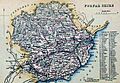
An old map of Angusshire (Forfarshire) from around 1854, showing its civil parishes.
._Civil_Parish_map.jpg)
See also
 In Spanish: Angus (Escocia) para niños
