Craigowl Hill facts for kids
Quick facts for kids Craigowl Hill |
|
|---|---|

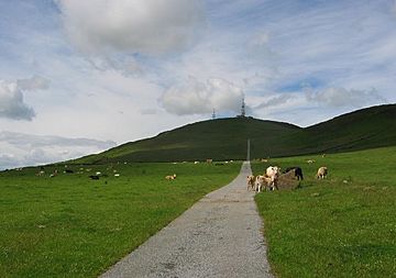
Road leading to masts on Craigowl Hill
|
|
| Highest point | |
| Elevation | 455 m (1,493 ft) |
| Prominence | 393 m (1,289 ft) |
| Parent peak | Lochnagar |
| Listing | Marilyn, Hardy |
| Geography | |
|
Lua error in Module:Location_map at line 420: attempt to index field 'wikibase' (a nil value).
|
|
| OS grid | NO376400 |
| Topo map | OS Landranger 53 |
Craigowl Hill is a cool summit located in the Sidlaw Hills in Angus, Scotland. It's about eight kilometers (or five miles) north of Dundee. This hill is special because it's the highest point in the entire Sidlaw range!
What is Craigowl Hill?
Craigowl Hill stands tall at 455 meters (about 1,493 feet) above sea level. It's known as a "Marilyn," which is a special term for a hill in the British Isles that is at least 150 meters (492 feet) higher than the land around it.
Where is Craigowl Hill located?
You can find Craigowl Hill towards the eastern end of the Sidlaw Hills. It's northeast of a small place called Kirkton of Auchterhouse. Its location makes it a great spot to see views of the surrounding Scottish countryside.
A Challenge for Cyclists
Craigowl Hill is also famous among cyclists. It has one of the toughest cycling climbs in all of Scotland! The climb is about 3.36 kilometers (2 miles) long and goes up very steeply, with an average slope of 9.4%. This means it's a real test for anyone on a bike!
 | Bayard Rustin |
 | Jeannette Carter |
 | Jeremiah A. Brown |

