
Carnoustie facts for kids
Quick facts for kids Carnoustie
|
|
|---|---|
 Carnoustie High Street |
|

Carnoustie
|
|
| Population | 11,310 (2020) |
| Demonym | Carnoustian |
| OS grid reference | NO561345 |
| • Edinburgh | 42 mi (68 km) SSW |
| • London | 367 mi (591 km) SSE |
| Council area | |
| Lieutenancy area | |
| Country | Scotland |
| Sovereign state | United Kingdom |
| Post town | CARNOUSTIE |
| Postcode district | DD7 |
| Dialling code | 01241 |
| Ambulance | Scottish |
| EU Parliament | Scotland |
| UK Parliament |
|
| Scottish Parliament |
|
Carnoustie is a town in Angus, Scotland, located on the North Sea coast. It sits at the mouth of the Barry Burn. In 2011, Carnoustie had a population of 11,394 people, making it the fourth-largest town in Angus.
The town started in the late 1700s. It grew quickly in the 1800s because of the local textile industry, which made cloth. Carnoustie was also a popular place for holidays by the sea, especially during the Victorian era. Today, it is most famous for the Carnoustie Golf Links course, which often hosts major golf tournaments like the Open Championship.
Carnoustie is also a "dormitory town" for Dundee, a larger city about 11 miles (18 km) to the west. This means many people live in Carnoustie but travel to Dundee for work. The town has two train stations, Carnoustie railway station and Golf Street railway station. The main road nearby is the A92, which runs north of the town.
Contents
- History of Carnoustie
- How Carnoustie is Governed
- Geography of Carnoustie
- People of Carnoustie
- Carnoustie's Economy
- Famous Places in Carnoustie
- Getting Around Carnoustie
- Schools in Carnoustie
- Religion in Carnoustie
- Sports in Carnoustie
- Public Services
- Twin Town
- Famous People from Carnoustie
- Images for kids
- See also
History of Carnoustie
What does the name Carnoustie mean?

The exact meaning of Carnoustie's name is not fully known. Some ideas link the first part of the name to old Gaelic words like cathair (fort), càrr (stone), or carn (cairn). The second part is harder to figure out.
A popular idea is that the name means "craws' nestie," which refers to the many crows and rooks that used to build nests here. The town's old seal even shows a tree surrounded by crows!
The name "Carnoustie" is much older than the town itself. It first appeared as "Carnowis" in a document from 1510. Over the years, it was spelled in different ways like "Carnussie" and "Carnushie" before becoming "Carnoustie" around 1703.
Early Days of the Area

People have lived around Carnoustie for a very long time, since the Neolithic period (New Stone Age). We know this from old crop marks that show where ancient monuments once stood. Many stones with cup and ring marks (ancient carvings) have also been found.
During the Bronze Age, people buried their dead in stone boxes called short cists. One found near Carnoustie in 1994 was dated to between 1730 and 1450 BC. There are also signs of Bronze Age burial mounds.
From the Iron Age, we have remains of forts and underground passages called souterrains, like those at Carlungie and Ardestie, which are about 1,800 years old. Roman coins and temporary army camps have also been found nearby.
The Picts, an ancient Scottish people, left many carved stones in the area. Some of these Pictish stones can be seen in museums. The famous Camus Cross, a large carved stone, is about 4 miles (6 km) north of Carnoustie.
In the Middle Ages, Arbroath Abbey was founded in 1178. Closer to Carnoustie, there were medieval castles and mounds called mottes, like at Old Downie and Grange of Barry. The original Panmure Castle was destroyed around 1336.
The land around Carnoustie was managed by monks from Balmerino Abbey in Fife from 1230. Over time, parts of the land were sold off to different families.
How Carnoustie Grew
The land that became Carnoustie was owned by the Fernie family until the late 1500s. It then changed hands several times. By the mid-1600s, there was already a small village called Carnoustie.
The town really started to grow because of a big demand for linen cloth around 1760. Weaving linen by hand was a good way to earn a living back then. In 1792, Major William Phillips bought the Carnoustie estate. He saw the potential for the local weaving industry and started selling plots of land in 1797.
The first person to buy land was Thomas Lowson, a local loom maker. More and more people moved to the area. In 1808, George Kinloch bought the estate for a much higher price. Kinloch helped the village grow even more by setting up brickworks and giving loans to people who wanted to build homes. By the mid-1800s, the town's population was over a thousand. For many years, the village was simply known as 'the Feus'.
Carnoustie's Industries
In its early years, Carnoustie's economy was mostly based on handloom linen weaving. Flax (the plant used to make linen) was grown locally. The 1841 census shows that "Linen Hand Loom Weaver" was the most common job. This industry helped the local population grow a lot.
Besides linen, people also worked in farming and fishing. Farmers grew crops and raised cattle. Fishermen caught salmon, cod, and haddock. They also caught lobsters to sell in London and crabs for local use.
The arrival of the Dundee and Arbroath Railway in 1838 brought more industry. A Vitriol Works opened, making sulfuric acid for farm fertiliser. A Bleachfield also opened to bleach linen.

In 1851, a shoe maker named John Winter started a business that grew into a large factory. It employed 200 people and made 2,000 pairs of shoes and boots each week.
The linen industry became more modern in 1857 when James Smieton opened the Panmure Works. This factory had 400 modern power looms and employed 600 people, producing millions of yards of linen and jute every year. Smieton also built new homes for his workers and opened the Panmure Works Institute, which had a library and a billiards room for their education and fun. The factory closed in 1972.
Another factory, Taymouth Linen works, opened in 1867. Later, it became home to George Anderson's company, which made quarrying equipment.
Carnoustie as a Commuter Town
The railway not only brought industries but also made Carnoustie an attractive place for middle-class people to live and travel to work in Dundee. This trend continues today, with almost half of Carnoustie's working population commuting to Dundee.
Fun and Tourism
.jpg)
In the 1800s, sea bathing became popular, and the railway helped Carnoustie become a favorite tourist spot. In the early 1900s, it was even called the "Brighton of the North."
Golf has been played on Barry links since the 1500s. A proper 10-hole golf course was designed in 1850. It was later improved by Old Tom Morris and then redesigned by James Braid in the 1920s. In 1891, the Earl of Dalhousie sold the links to the town, making sure they would always be used as a golf course.
Tourism in Carnoustie started to slow down in the late 1900s as people began taking package holidays to warmer places. However, golf tourism has helped bring visitors back to the town.
How Carnoustie is Governed
Carnoustie is part of the Angus Council area. Three councillors are elected from the Carnoustie & District ward to represent the town.
For the Parliament of the United Kingdom in London, Carnoustie is part of the Dundee East constituency. This constituency elects one Member of Parliament (MP). The current MP is Stewart Hosie from the Scottish National Party.
For the Scottish Parliament in Edinburgh, Carnoustie is part of the Angus South constituency. This constituency elects one Member of the Scottish Parliament (MSP). The current MSP is Graeme Dey from the Scottish National Party.
Geography of Carnoustie

Carnoustie is located on the North Sea coast of Scotland. It is about 10 miles (16 km) northeast of Dundee and 6.5 miles (10 km) southwest of Arbroath. The town is relatively flat, rising slightly to the north. The weather is typical for Scotland's east coast, sometimes with sea mist called "haar."
The town is built across the border of two old parishes, Barry and Panbride. It includes several smaller villages and hamlets that have grown together, like Westhaven and Panbride. To the west is the village of Barry, and to the east is the hamlet of Panbride. The A92 runs north of the town.
Two small streams, the Lochty burn and the Barry Burn, flow through the town. The western part of the town is in the floodplain of the Barry Burn.
The Dundee and Arbroath Railway runs along the south of the town. The main road, the A930, goes through the town and is called Barry Road, Dundee Street, and High Street.
The coast east of the Lochty burn is rocky, with Old Red Sandstone visible. To the west is the sandy Carnoustie Beach. The land here used to be sandy dunes. The area to the south of the golf courses, called Barry Buddon, is a special protected area for nature.
The Buddon Ness is a triangular piece of land that has changed shape over time due to erosion from the sea. Rocks were placed on the shoreline in 1994 to help protect the beach from eroding.
People of Carnoustie
In 2011, Carnoustie had 11,394 residents. Most people (87.4%) were born in Scotland. About 0.5% of the population speak Gaelic, and 32.2% can speak Scots. Most working-age people (69.9%) are employed.
Carnoustie's Economy
Carnoustie's economy largely depends on its closeness to Dundee. Many people from Carnoustie travel to Dundee for work.
Golf is a big attraction for tourists. It's estimated that a recent Open Championship brought £14 million to the local economy. The "Carnoustie Country" campaign helps promote the area for golf tourism.
Famous Places in Carnoustie

At the western end of town is the village of Barry. Here you can find the ruins of the old parish church and the Barry Mill, a water-powered corn mill built in 1815 on the site of an even older mill. It's a very old and important building.
Much of western Carnoustie was built after World War II. The main road here is Barry Road. Further east, you'll find Panmure Street, which leads to the Panmure Centre (once the Panmure Institute) and the old Panmure Works factory, now used by a building firm.
Carnoustie House Grounds is now a park where the town's annual gala is held. It used to be the site of Carnoustie House, built in 1792. Woodlands Primary School and a caravan park are now on part of this land.

On Dundee Street, you can see the former St Annes Roman Catholic Church and the large grounds of Kinloch Primary School, which opened in 1878. The school buildings were taken down in 2010 to build new homes.
Near the beach, Links Avenue leads to the scout hut, which is actually the oldest school building in Carnoustie. It also leads to the Carnoustie Hotel, built for the 1999 Open Championship. The hotel has a large Rolex clock, one of only 40 worldwide on golf courses. Beyond the hotel are the three golf courses of Carnoustie Golf Links.
Further along Dundee Street, you'll find Carnoustie Church, which was never given its steeple. Nearby is the 'Auld Nick', which used to be Carnoustie's police station. The war memorial, dedicated in 1926, features a sculpture of the Unknown Soldier.
The 'Dibble Tree' of Thomas Lowson, one of the town's first residents, can be seen on Ferrier Street. On Kinloch Street, the Erskine United Free Church, built in 1810, is the oldest church building in Carnoustie.

First Feu Cottage, Thomas Lowson's original home, is on Dundee Street. The traditional center of town is 'the Cross', where several main streets meet. The Church of the Holyrood, a beautiful old building, is on Maule Street.
At the eastern end of High Street, you'll find Station Road leading to the main railway station and the Station Hotel, built in 1840. The old City of Glasgow Bank building, built in 1870, is also nearby. Church Street continues east towards the former fishing village of West Haven. In Panbride, you can find Panbride Parish Kirk, a church that has been a place of worship since 1147.
Getting Around Carnoustie

The A92 runs north of Carnoustie, connecting Arbroath and Dundee. There are several ways to get onto this main road.
Trains run by ScotRail stop at Carnoustie railway station about once an hour. Two trains a day also stop at Golf Street railway station and Barry Links. Because so few trains stop there, Golf Street and Barry Links are two of the least used train stations in the UK!
Buses are run by Stagecoach East Scotland and connect Carnoustie to Dundee and Arbroath regularly. Other coach services also travel to many destinations across Scotland.
Schools in Carnoustie
How Schools Used to Be
In the early 1870s, each church in Carnoustie had its own school. Some of these old school buildings can still be seen today. There were also private schools. However, a new law in 1872 changed things, leading to bigger public schools.
Carnoustie Public School was built in 1878 on Dundee Street. It was expanded many times. Eventually, older students moved to the new Carnoustie High School. The old school was renamed Kinloch Primary School and closed in 2006.
Schools Today

Today, Carnoustie has three primary schools and one high school:
- Carlogie Primary School opened in the mid-1970s. It serves the eastern part of Carnoustie and nearby rural areas.
- Woodlands Primary School is located in the Carnoustie House Grounds. It serves the central part of Carnoustie and rural areas to the north.
- Burnside Primary School is on Thomas Street. It serves the western part of Carnoustie and the former rural area of Barry Primary.
- Carnoustie High School is on Shanwell Road. It takes all secondary school students from Carnoustie and the surrounding rural areas. The school was almost completely rebuilt in 2008.
Religion in Carnoustie
A Look at the Past
The site of Panbride Church has been a place of worship since 1147. The current building was built in 1681. The parish of Barry was founded in 1230. The first church there was consecrated in 1243. The building used until the 1950s was built in 1800.
In 1810, two different branches of the United Secession Church built churches in Carnoustie. One was called the 'Red Kirk'. As the town grew, the Barry Parish Church became too small. This led to the building of Carnoustie Church in 1837. The Disruption of 1843, a big split in the Church of Scotland, had a major impact. New Free Churches were set up, including one that became St Stephen's church.
The Scottish Episcopal Church started meeting in Carnoustie in 1853 and built The Church of The Holyrood in 1881. Over the years, many churches merged. For example, the congregations of Carnoustie Church and St Stephen's merged in 1969.
Churches Today

Today, the Church of Scotland has three congregations in Carnoustie:
- Carnoustie Church and Barry Church share a minister.
- Carnoustie Panbride church meets at Newton Church in winter and Panbride Church in summer.
The Episcopalian congregation meets at Holyrood church. The Roman Catholic Church meets at the modern St Anne's Church, built in 2000. The Carnoustie Erskine United Free Church of Scotland meets on Kinloch Street. The Carnoustie Community Church is a Baptist church that meets in a building called 'The Bridge'.
Sports in Carnoustie
Golf

Carnoustie is world-famous for golf. Golf has been played here since the 1500s. Carnoustie Golf Links has three courses: the Championship course, the Burnside course, and the Buddon course.
The Championship course is one of the courses that hosts The Open Championship, a major international golf tournament. It first hosted The Open in 1931. Famous winners include Ben Hogan (1953), Gary Player (1968), Tom Watson (1975), Paul Lawrie (1999), Pádraig Harrington (2007), and Francesco Molinari (2018).
The 1999 Open Championship is well-remembered because French golfer Jean van de Velde had a big lead but struggled on the last hole, losing the championship in a playoff to Paul Lawrie. Because of how tough the course was that year, the media nicknamed it 'Carnasty'.
Carnoustie is also one of the three courses used for the Alfred Dunhill Links Championship.
In the early 1900s, about 300 golfers from Carnoustie moved to the United States and helped develop the sport there. When the Professional Golfers' Association of America was founded in 1916, almost half of its professional members were from Carnoustie!
Football
Carnoustie has a junior football club called Carnoustie Panmure F.C.. They are nicknamed the Gowfers because of the town's strong connection to golf ("gowf" is the Scots word for golf). They play at Laing Park.
The club has become one of the strongest teams in their league, winning the Scottish Junior Cup in 2004. Carnoustie Panmure Youth FC is one of the biggest youth football clubs in the area, with teams for boys from 9 to 19 years old. They also have a Football Academy for younger boys and girls.
In 2012, the main football clubs in Carnoustie joined together to form Carnoustie Panmure FC as a charity. Their goal is to improve football facilities and pathways for players in the area.
Rugby
Carnoustie also has a lively rugby club, Carnoustie HSFP. Their first team plays in Division 2 of the Caledonia Regional League.
Public Services
Carnoustie gets its water from reservoirs in Glen Isla. Electricity is supplied by Scottish Hydro Electric. Angus Council handles waste management, with weekly recycling collections for cans, glass, paper, and plastic bottles. There's also a recycling centre at Balmachie Road.
Healthcare is provided by NHS Tayside. The main health centre in Carnoustie is Parkview Health Centre. Law enforcement is handled by Tayside Police, and fire services by Tayside Fire and Rescue Service.
Twin Town
Carnoustie is twinned with Maule, a town about 30 miles (50 km) west of Paris, France. This connection is because of Carnoustie's long history with the Maule Family.
Famous People from Carnoustie
- The philosopher and historian, Hector Boece, from the 1500s, is thought to have lived in the Panbride parish.
- Two streets in Carnoustie are named after Victoria Cross winners: Lance Corporal Charles Jarvis and Petty Officer George Samson. They both won the highest military award for bravery.
- The actor Ian McDiarmid, famous for playing Emperor Palpatine in the Star Wars films, lived in Carnoustie as a child.
- Alan Cumming, an actor who has starred in films like GoldenEye, attended Carnoustie High School.
- Iain Macmillan, the photographer who took the famous Abbey Road album cover for The Beatles, was born in Carnoustie.
- Alex Smith, a two-time winner of the U.S. Open golf championship, was born in Carnoustie in 1874.
- Liz McColgan, an Olympic runner and coach, lived near Carnoustie. She won a silver medal at the 1988 Olympics and gold at the 1991 World Championships. She also won several major marathons.
- Fred Martin, a goalkeeper for Aberdeen F.C. and Scotland's 1954 World Cup squad, was born in Carnoustie.
- Kevin McDonald, a midfielder for Fulham F.C., was born in Carnoustie in 1988.
Images for kids
-
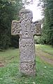
Camus Stone
-
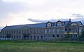
James Smieton's Panmure Works, built in 1857. Now housing D.J. Laing
-
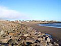
Carnoustie Beach with rocks to combat coastal erosion
-
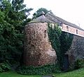
Barry Mill
-
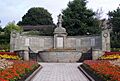
War memorial
-
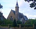
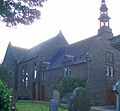
Church of the Holyrood
-
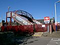
Golf Street railway station
-
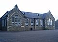
Carnoustie Public School, later Kinloch Primary School, demolished summer 2010
-
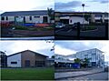
Schools in Carnoustie. Clockwise from top left: Carlogie Primary School; Burnside Primary School; Carnoustie High School; Woodlands Primary School
-
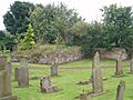
The old parish church at Barry, built 1800, demolished in 1965.
-
Erskine United Free Church, the Original Secessional Church, built 1810
-
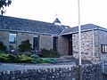
Panbride Church
-
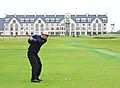
Carnoustie Championship Course, 18th tee


See also
 In Spanish: Carnoustie para niños
