
Montrose Basin facts for kids
Quick facts for kids
Designations
|
|
| Official name: Montrose Basin | |
| Designated: | 3 February 1995 |
|---|---|
| Reference #: | 716 |

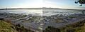
The Montrose Basin is a special place in Scotland, near the town of Montrose. It's a large, almost round area of water that is part of the River South Esk estuary. An estuary is where a river meets the sea, and the water is a mix of fresh and salt water.
This basin is very important for nature. It's protected by many special rules and is managed by the Scottish Wildlife Trust. It's known as a Wildlife Reserve, a Local Nature Reserve, a Site of Special Scientific Interest, a Special Protection Area, and a Ramsar Site. These titles mean it's a globally important wetland.
Contents
What is the Montrose Basin like?
The Montrose Basin is a tidal basin. This means the water level changes a lot with the tides, exposing large areas of mud. It has many different natural areas, called habitats.
- Mudflats: These are wide, muddy areas that appear when the tide is out.
- Saltmarsh: This is land covered by special grasses and plants that can grow in salty water. It's the biggest saltmarsh area in Angus.
- Reedbed and Fen: These are wet areas with tall grasses and other plants.
- Farmland: Around the basin, there are fields used for growing crops and for animals to graze.
There's also a small freshwater lake called Dun's Dish nearby. Scientists study the area at Maryton to learn how sea levels have changed since the last Ice Age.
What animals live in Montrose Basin?
The Montrose Basin is a fantastic home for many different animals, especially birds.
Tiny creatures in the mud
The huge mudflats are full of small creatures. These include:
- Worms called annelids.
- Small snails called Hydrobia.
- Tiny shrimp-like animals called Corophium.
- Beds of mussels, which are shellfish.
There are also three types of special underwater grasses called Zostera (eelgrass) and different kinds of algae. These tiny creatures and plants are food for many birds.
Birds of the Basin
Many birds visit or live at Montrose Basin. Some of the birds you might see include:
- Eurasian oystercatchers, with their bright orange beaks.
- Common redshanks, known for their red legs.
- Red knots, which travel long distances.
- Graceful mute swans.
- Eurasian wigeons, a type of duck.
- Common eiders, large sea ducks.
Huge groups of pink-footed gooses and greylag gooses use the basin to rest safely. They also fly to nearby farms to find food. Many eider ducks also breed here, meaning they lay their eggs and raise their young.
In total, over 200 different kinds of birds have been seen at the basin! Most of these are visitors in winter or birds passing through on their long journeys. About 50 types of birds actually breed here.
Visitor Centre
If you want to learn more, the Scottish Wildlife Trust opened a visitor centre in 1995. It's on the south side of the basin at Rossie Braes.
What is the history of Montrose Basin?
People have lived near the Montrose Basin for a very long time.
Ancient history
The oldest signs of humans in the area go back over 5,000 years! There's an ancient monument called the cursus, which runs from Powis to Old Montrose. It shows that people were here even before written history.
Fishing and farming
For many years, people used the basin for fishing. They especially caught Atlantic salmon. However, commercial salmon fishing here stopped in 2018. The basin was also famous for its mussels. In the 1800s and early 1900s, it had the biggest mussel beds in the whole country!
A giant wave
About 8,100 years ago, the Montrose Basin was hit by a huge tsunami. This giant wave was caused by a massive underwater landslide in Norway called the Storegga Slide. When the tsunami reached the basin, it was about 70 feet (21 meters) high! The water traveled far inland, reaching as far as Forfar.
Images for kids
-
Montrose Basin
