
Strathmore, Angus facts for kids

Strathmore (in Gaelic: An Srath Mòr) is a long, wide valley in east central Scotland. It stretches from the northeast to the southwest. This valley sits between the Grampian Mountains and the Sidlaws.
Strathmore is about 50 miles (80 km) long and 10 miles (16 km) wide. The land beneath it is made of Old Red Sandstone. However, this rock is mostly covered by glacial till, which are soils, sands, and gravels left behind by glaciers during the ice age. The valley's direction (northeast to southwest) is shaped by the ancient Caledonian mountain-building event. The northern edge of Strathmore follows the line of the Highland Boundary Fault. This area is very fertile and has some of Scotland's best farmland. Farmers here grow crops like soft fruits and cereals.
What is the History of Strathmore?
The first records of Strathmore come from the time of the Romans. They set up temporary camps here as they explored and tried to invade northward. Other early signs of history include Pictish stones. These are ancient carved stones found in Strathmore, like the Eassie Stone.
The noble title of Earl of Strathmore is connected to this area. The main home of the Earl, Glamis Castle, is also located within Strathmore.
Images for kids
-
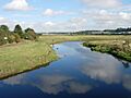
The River Isla flows through Strathmore near Coupar Angus.
