Errol, Perth and Kinross facts for kids
Quick facts for kids Errol |
|
|---|---|
 Errol Parish Church |
|
| Population | 1,490 (2020) |
| OS grid reference | NO252228 |
| Council area | |
| Lieutenancy area | |
| Country | Scotland |
| Sovereign state | United Kingdom |
| Post town | PERTH |
| Postcode district | PH2 |
| Dialling code | 01821 |
| Police | Tayside |
| Fire | Tayside |
| Ambulance | Scottish |
| EU Parliament | Scotland |
| UK Parliament |
|
| Scottish Parliament |
|
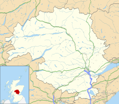
Errol is a village in Perth and Kinross, Scotland. It's located about halfway between the cities of Dundee and Perth. Errol is one of the main villages in an area called the Carse of Gowrie. It lies just north of the River Tay. In 2016, about 1,500 people lived in Errol.
Errol is part of the Perthshire North area for the Scottish Parliament. It is also twinned with Mardié, a village in France.
The village is surrounded by flat farm fields. It has a great view over the Firth of Tay. Errol is known for its reeds that grow along the River Tay. These reeds used to be collected to make thatched roofs. They are also home to a special bird called the bearded tit.
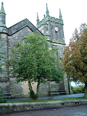
Errol has a very large church built in 1831. It is known as the "Cathedral of The Carse" because it's so big. You can see it from most parts of the village and from far away.
The village is on National Cycle Route 77, which goes from Dundee to Pitlochry. It is also about 1 mile (1.5 km) from the A90 road, a main road between Perth and Dundee. This makes Errol a popular place for people who travel to work. The village has a strong local community with a church, a village hall, a bowling club, a pub, and a cafe. There is also an annual gala and other groups.
Contents
History of Errol
Early Times
People have lived in the Errol area for a very long time. Experts believe that a ring ditch east of Mains of Errol was once a timber roundhouse. You can see its shape from aerial photos. At Hill of Errol, aerial images show signs of an old settlement. This includes a rectangular building and pits. There is also a standing stone at Clashbenny from the Stone Age or Bronze Age.
Village Life and Changes
The area of Errol Parish has been around since the 1100s. A family called Hay was given control of the land back then. Later, one of their family members became the Earl of Erroll. The oldest birth and marriage records in Scotland are from Errol parish. They date back to 1553.
In 1689, government troops came to Errol. The local minister, Dr John Nicolson, did not agree with the new government. He lost his job in 1691.
In 1791, William Herdman wrote about the changes in farming in Errol. Many different crops were grown. Grain was sent to Perth and Dundee. Large amounts were also shipped from Port Allen by sea. In 1791, Errol had 2,685 people. Most of them lived in the countryside. The main jobs were weavers, carpenters, tailors, and shoemakers. There were also bakers, butchers, and lawyers. The village had seven inns and a school.
In January 1814, the River Tay froze completely. People could walk across the ice from Port Allen at Errol to Newburgh.
By 1837, the population of Errol parish was about 2,942 people. About 1,220 of them lived in the village. Many families worked in farming. Others worked in trade, manufacturing, or crafts. The village had a library, a friendly society, and a savings bank. Farmers would hire workers at a special market in July. The village also had three inns and eight ale houses.
In the late 1800s, Errol was known for its weavers and factory workers. It had a post office, a bank, two inns, and two schools. Fairs were held in July and October.
In 1887, Errol was described as a business center for the Carse of Gowrie. This was because it had chemical works and a machine-making factory.
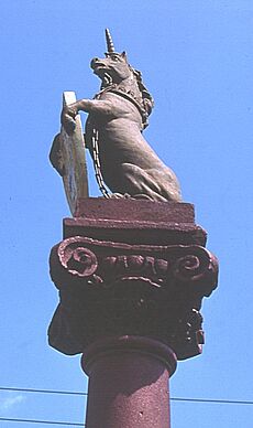
The water supply for Errol was not good until 1897. Sir William Ogilvy Dalgleish paid for a new supply from moorland above Fingask. To celebrate this, a special market cross was built in 1900. It was made of red stone with granite basins. It had a carved lion's head fountain and a unicorn on top.
A local farmer and scientist named Patrick Matthew lived in Errol. He planted a large orchard at Gourdiehill. In 1831, he wrote a book that included early ideas about natural selection. He was also the first person to bring Giant Redwood tree seeds to the UK. There is now a special path called the Patrick Matthew Trail in his memory.
Errol Park Estate
The land of Errol Park changed hands many times over the centuries. In 1745, a London banker named George Middleton built a house there. This house was later destroyed by fire in 1874.
The Allen family owned Errol Park in the late 1700s. They built the beautiful circular stables in 1811. These stables are still famous today. The Allen family sold Errol Park in 1873. A new house was designed by architect Alexander Johnston.
Later, Elizabeth Frances Molison inherited Errol Park. She married William Dalgleish. Elizabeth was known for helping young women, education, and people with vision problems.
Today, Jamie Heriot Maitland is the owner of Errol Park. His great-grandfather, Brigadier-General J D Heriot Maitland, inherited it after World War I.
Churches in Errol
The old churchyard in School Wynd was the first site of the parish church in the 1600s. A church was built there in 1765.
The main Errol North Church was built in 1832. It was designed to hold many people. The church has a cross shape and a tall square tower with pointed tops. It is a very important historical building. The churchyard has old gravestones with carvings.
In the 1840s, there were other churches in Errol too. These included the United Secession Church, the Free Church of Scotland, and the Relief Church.
The Free Church was built in 1843. The local minister and many people from his church left the main church to join the Free Church. This building was later used as a small workshop.
Schools in Errol
Schools were set up in parishes by law in 1696. This means Errol likely had its first school in the 1700s. In 1791, Errol had a school and a schoolmaster. This parish school was located near School Wynd.
By 1837, Errol parish had five schools. The main parish school taught English, math, geography, and languages. Three other schools were supported by donations or fees. The fifth school was a small house where an "elderly widow" taught young children to read and girls to knit. There were also Sunday schools linked to the different churches.
An Industrial School was started to teach young women skills for home life. It was built in 1855. The school helped young women learn practical skills. It closed as an industrial school in 1914. Later, it became an infant school until the 1970s. Today, it is a community center.
In 1872, new laws changed how schools were controlled and funded. The main school building in Station Road was likely built around 1925. In the 1960s, extra buildings were added for classrooms and dining. In the mid-1970s, the secondary school part closed. Older students then started traveling to Perth for high school.
Port Allen
Port Allen has had different names over time, like Miln of Errol and Harbour of Errol. It was an important port for shipping goods. In 1791, large amounts of grain were shipped from here. Old maps show the port with a pier and a crane. There was also a water-powered mill.
Errol Aerodrome
The Errol airfield has a long history with flying. It is located on flat land between Errol village and the hamlet of Grange. During World War II, the land was taken over by the government. It opened as an RAF station in 1942 to train pilots. The aerodrome was used by the military until 1948. German prisoners of war helped load and unload materials there.
After the war, Errol was considered for a public airport but it didn't happen. The airfield was sold in 1961. In 1988, Morris Leslie bought the airfield. It is now a business park and the company's main office. The main runway is still used for planes.
Inchcoonans Tile and Brick Works
People have made clay products in Errol for hundreds of years. The Romans first brought brick-making to the area. The site has two special "Beehive kilns." These are the only ones left in Scotland.
Inchcoonans Tile Works opened in 1855. It mainly made bricks for buildings and drainage tiles for fields. The works closed in 1990 but reopened in 1994. It was then closed again in 2008.
Errol Railway Station
Errol railway station opened in 1847. It was part of a line that connected Dundee and Perth. The station is located north of the village. The station closed in 1985.
The station building is now a protected historical site. It was sold to a trust and opened as The Railway Heritage Centre in 1990. It even won an award for being the best-preserved station in Britain that year. The museum later closed, and the buildings are now homes.
Errol Today
Errol is still known for its local factory. The old brick factory is now a modern plant that makes potato crisps for the Mackie's company. It used to have a factory shop, but that is now closed.
Errol also has a beautiful farm track where you can walk or bike. It runs right beside the River Tay. You might find a rope swing that goes over a tidal mud flat. This mud flat was once a protected lagoon. But a big storm in late 2023 broke the wall that protected it. The areas around Errol are great for walking dogs.
Errol Park house and gardens are now used for weddings and filming movies. Errol Estate is a large farm around the village. It has about 3,500 acres of farmland and woods near the River Tay.
The main runway of Errol Aerodrome is still used for planes and drones. The old airfield also hosts the Errol car boot sale and market. This market is run by the Morris Leslie group and is called "Scotland's premier Sunday market." The group also holds auctions there.
Errol School is a primary school with eight classes and a large nursery. It was made bigger in 2017 because more students were joining.
Errol has two grocery shops. Other local places include a chip shop, a pub, a community center, a pharmacy, and a hairdresser. The post office closed in 2023. The Lass O'Gowrie Cafe opened in 2022 in the old Picture House.
The local winery, Cairn O'Mohr, has won many awards. They make wines from local produce like oak sap, rhubarb, and brambles. It's located on the same farm as Gillies & Mackay Ltd, a local shed company.
There are many paths around Errol. The Gas Brae path down to the river and the reed beds is very popular. Some of these paths are part of the Perth & Kinross Council Core Path Network. Volunteers and local landowners help maintain the paths. The community hopes to add even more paths in the future.
On April 27, 2020, there was a long dry period. The River Tay reed beds at Errol caught fire. Almost 2 miles (3 km) of reeds were lost. This destroyed the nests of rare bearded tits and marsh harriers. A local pilot dropped 77,000 liters of water from the river to help put out the fire. Nine fire trucks were also involved.
See also
 In Spanish: Errol (Escocia) para niños
 | Lonnie Johnson |
 | Granville Woods |
 | Lewis Howard Latimer |
 | James West |


