Lismore, Scotland facts for kids
| Meaning of name | great garden or great enclosure |
|---|---|
| OS grid reference | NM840408 |
| Coordinates | 56°31′N 5°30′W / 56.52°N 5.5°W |
| Physical geography | |
| Island group | Inner Hebridies |
| Area | 2,351 ha (5,810 acres) |
| Area rank | 33 |
| Highest elevation | Barr Mòr, 127 m (417 ft) |
| Administration | |
| Sovereign state | United Kingdom |
| Country | Scotland |
| Council area | Argyll and Bute |
| Demographics | |
| Population | 192 |
| Population density | 8.2/km2 (21/sq mi) |
| Largest settlement | Achnacroish |
Lismore (which means "great enclosure" or "garden") is a beautiful island in the Inner Hebrides of Scotland. It covers about 23.5 square kilometers (9 square miles). The island has a mild and damp climate, with a lot of rain each year.
Lismore was once a very important place for Celtic Christianity. A monastery linked to Saint Moluag was built here in the 6th century. Later, it became the home of the medieval Bishop of Argyll. You can still see many old ruins on the island, including an ancient broch and two castles from the 13th century.
In the 1800s, new industries like lime quarrying started on Lismore. The island's population grew to over 1,000 people in the early 1900s. However, it then saw a long decline. Today, fewer than 200 people live on Lismore, but the number has recently started to increase. About a third of the people living here speak Scottish Gaelic. The main jobs on the island today are farming, fishing, and tourism. The biggest village is Achnacroish. Many shipwrecks have happened near Lismore over the years.
Contents
What's in a Name? The Meaning of Lismore
The name Lismore comes from the Gaelic words lios and mòr. Lios means "garden" or "enclosure," and mòr means "big" or "great." This name might describe how fertile the island is, surrounded by tall mountains. Or it could refer to a special area around the old monastery. One of the first times Lismore was written about in English was in the 1500s, as "Lismoir."
Other places on the island also have interesting names:
- Achnacroish means "the field of the cross."
- Clachan means "village with a church."
- Port Ramsay is named after Eilean Ramsay, which means "Ramsay's isle."
- Many small islands nearby also have descriptive names, like Eilean Dubh ("black island") and Pladda ("flat island," from an old Norse word).
Island Rocks: Lismore's Geology
Lismore is mostly made of a type of rock called limestone. This limestone formed a very long time ago. Because of this limestone, the island has very fertile soil. You can also find some dark, slaty rocks mixed in.
Over time, different types of molten rock pushed their way into the limestone, forming dykes. These are like walls of rock that cut through the older layers.
The island also has deposits from the ice age. These include till (rock and dirt left by glaciers) and peat (decayed plant matter). Near the coast, you can see old beach deposits that show how sea levels have changed over thousands of years. The whole of Scotland was covered by ice during the last ice age. On Lismore, you can see marks on the rocks near the coast that were made by moving ice.
Exploring Lismore's Geography
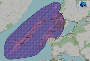
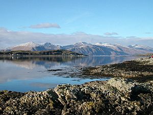
Lismore island is located in Loch Linnhe, northeast of the Isle of Mull. It is part of the Argyll and Bute council area. The island is about 15 kilometers (9 miles) long and 2 kilometers (1.2 miles) wide. It runs from southwest to northeast, similar to the Great Glen Fault. To the east, there's a part of Loch Linnhe called the Lynn of Lorn.
Since Lismore is mostly made of limestone, it has rich soil. Many trees and shrubs grow here, including ash and sycamore. The island's landscape has sheltered areas of land between higher ridges that run along its length.
The island covers about 23.5 square kilometers (9 square miles). The highest point is Barr Mòr in the south, which is only 127 meters (417 feet) high.
There are several small lochs (lakes) on the island. The biggest ones are Loch Fiart, Kilcheran Loch, and Loch Baile a' Ghobhainn. These three lochs are special because they are some of the best examples in Scotland of lochs that sit on limestone. Their water is very clear and clean. They are home to rare types of Chara stoneworts, which are a type of algae. These lochs are home to trout.
Lismore is part of the ancient area called Lorne. Today, it is in the middle of the Lynn of Lorn National Scenic Area. These areas are chosen in Scotland for their amazing scenery. They are protected to make sure they stay beautiful. This area covers a large space, including all of Lismore and nearby mainland areas like Benderloch and Port Appin.
From Barr Mòr, the highest point, you can see incredible views. Even though it's not very high, the view of the surrounding mountains and sparkling seas is truly special.
The small islands around Lismore, like Eilean na Cloich and Eilean Dubh, are used by common seals. These islands are also protected areas. Bernera island is another important spot, known for its limestone cliffs and a rare tree called rock whitebeam. The Lismore Lighthouse, built by Robert Stevenson, stands on the small island of Eilean Musdile to the southwest.
Lismore's Weather: A Maritime Climate
Lismore has a maritime climate. This means it has cool summers and mild winters. The closest weather station that records official weather information is at Dunstaffnage, near Oban on the mainland.
| Climate data for Dunstaffnage 3m asl, 1971-2000 (Weather station 2.7 kilometres (2 mi) NNE of Oban) | |||||||||||||
|---|---|---|---|---|---|---|---|---|---|---|---|---|---|
| Month | Jan | Feb | Mar | Apr | May | Jun | Jul | Aug | Sep | Oct | Nov | Dec | Year |
| Record high °C (°F) | 13 (55) |
13 (55) |
15 (59) |
24 (75) |
25 (77) |
27 (81) |
27 (81) |
27 (81) |
24 (75) |
20 (68) |
15 (59) |
13 (55) |
27 (81) |
| Mean daily maximum °C (°F) | 7.0 (44.6) |
7.2 (45.0) |
8.6 (47.5) |
11.0 (51.8) |
14.5 (58.1) |
16.2 (61.2) |
17.7 (63.9) |
17.7 (63.9) |
15.4 (59.7) |
12.6 (54.7) |
9.4 (48.9) |
7.9 (46.2) |
12.1 (53.8) |
| Mean daily minimum °C (°F) | 2.1 (35.8) |
2.2 (36.0) |
3.0 (37.4) |
4.2 (39.6) |
6.6 (43.9) |
8.8 (47.8) |
10.9 (51.6) |
10.9 (51.6) |
9.3 (48.7) |
7.3 (45.1) |
4.3 (39.7) |
3.0 (37.4) |
6.1 (43.0) |
| Record low °C (°F) | −8 (18) |
−7 (19) |
−7 (19) |
−2 (28) |
0 (32) |
2 (36) |
5 (41) |
3 (37) |
1 (34) |
−1 (30) |
−6 (21) |
−8 (18) |
−8 (18) |
| Average precipitation mm (inches) | 192.2 (7.57) |
139.5 (5.49) |
153.2 (6.03) |
80.1 (3.15) |
67.0 (2.64) |
82.6 (3.25) |
102.4 (4.03) |
119.2 (4.69) |
163.3 (6.43) |
186.9 (7.36) |
182.1 (7.17) |
192.4 (7.57) |
1,660.9 (65.39) |
| Average precipitation days (≥ mm) | 27 | 23 | 28 | 24 | 23 | 26 | 24 | 26 | 27 | 28 | 27 | 27 | 310 |
| Average rainy days (≥ mm) | 25 | 21 | 27 | 24 | 23 | 26 | 24 | 26 | 27 | 28 | 27 | 27 | 305 |
| Average snowy days (≥ cm) | 7 | 6 | 5 | 1 | 0 | 0 | 0 | 0 | 0 | 0 | 1 | 3 | 23 |
| Mean monthly sunshine hours | 33.5 | 59.6 | 86.2 | 145.8 | 189.7 | 174.9 | 142.6 | 141.7 | 97.5 | 75.6 | 46.2 | 30.7 | 1,224 |
| Source 1: Met Office | |||||||||||||
| Source 2: Weatherbase | |||||||||||||
Ancient Times: Lismore's Prehistory
Lismore has several ancient burial mounds called Bronze Age cairns. These date back thousands of years.
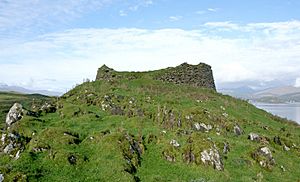
Tirefour Castle is an Iron Age broch. A broch is a type of round stone tower. This one is a famous landmark on Lismore's east coast. Its walls are about 4.5 meters (15 feet) thick. They enclose a circular area about 12.2 meters (40 feet) across. Parts of the wall still stand 3 meters (10 feet) high. There might be another broch at An Dùn, southwest of Loch Fiart. These are some of the most southerly examples of these mysterious old forts. There are also other ancient forts called duns on the island. They might be from the 1st or 2nd centuries AD.
Lismore Through Time: A Brief History
Early Christianity and Vikings
Lismore was a very important place for Celtic Christianity from early on. Records show that Saint Moluag, who was likely the head of the Lismore monastery, died in 594. Other important religious leaders from Lismore also died in the 600s and 700s. This shows that Lismore was a key religious center.
In the 6th century, Lismore was part of the kingdom of Dalriada. This was a Gaelic kingdom in what is now Scotland and Northern Ireland. Later, in the late 700s, the Vikings arrived. Lismore likely became part of the Kingdom of the Isles, which was ruled by Norse-Gaelic kings. By 1098, a Norwegian king named Magnus Barelegs took control of this sea kingdom. However, Lismore remained under Scottish rule.
Medieval Castles and Bishops
Lismore later became the main base for the medieval Bishop of Argyll. Before the late 1100s, the Bishop of Dunkeld looked after all of Argyll. But then, the areas were separated. Lismore became the home of the new bishop. The bishops were known as Episcopi Lismorenses. In 1249, the Pope suggested moving the bishop's seat to a safer place.
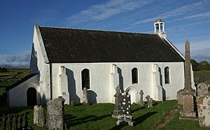
However, St Moluag's cathedral at Clachan stayed the main church until 1507. Then, the center of the diocese moved to Saddell. The cathedral was burned down during the Reformation. Today, only the choir section remains, much changed. The main part of the church and its tower are just foundations.
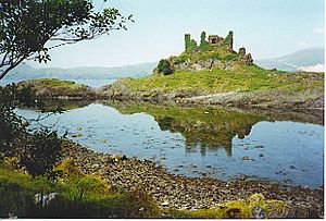
The ruins of Coeffin Castle stand on a rocky point on the west coast near Clachan. You can see the outline of an old hall-house, possibly from the 13th century. There's also a strangely shaped outer area, likely built later. Near the castle, there's an old fish trap in a small bay.
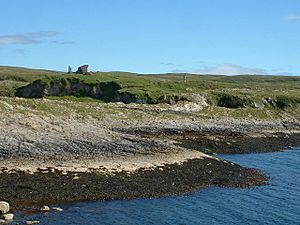
The remains of Achanduin Castle, west of Achnacroish, are also thought to be from the 13th century. The MacDougalls built it around 1290. They held it through the 1300s. After that, the Bishops of Argyll likely owned it until the mid-1500s. The castle looks out over the island of Bernera.
In the 1500s, a priest named Donald Monro wrote about Lismore. He said it was an island with lead ore, opposite Duart. He also mentioned that it was four miles long and had a church. He described nearby islands as good for growing crops and raising animals.
Lismore is the home of the Clan MacLea. They are related to the Livingstone family. The Plod nam Baran, near Saint Moluag's church, might be where the clan chiefs were buried. The current chief, Niall Livingstone of Bachuil, is known as the "Coarb of Saint Moluag." Since the 1500s, the chiefs have been the guardians of the saint's staff, called the Bachuil Mòr.
From the 1700s to the 1900s
In 1707, England and Scotland joined to form the Kingdom of Great Britain. After this, taxes on whisky making went up a lot. Many distilleries closed or went underground. Remains of at least two illegal whisky stills from this time have been found on Lismore.
In 1749, the old cathedral ruins were repaired and given a roof. They became a parish church with a bell tower.
In the 1800s, lime was quarried on the island, especially on the west coast. You can still see the ruined homes of the quarry workers on nearby islands. Old lime kilns, used to process the lime, can be seen in several places. The last lime was made in 1934.
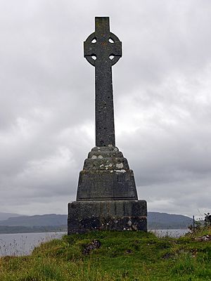
John Stuart McCaig, who designed McCaig's Tower in Oban, was born on Lismore in the 1800s. So was the famous storyteller Alexander Carmichael. Overlooking Lismore Bay, there is a Celtic Cross. This memorial is for Waverley Arthur Cameron, who drowned nearby in 1891. He was the son of Duncan Cameron, who invented the "Waverley" pen and owned The Oban Times newspaper.
Many other ships have been wrecked near Lismore. In 1889, the Mountaineer ship crashed onto Lady's Rock. In 1905, another ship, the Clydesdale, hit the same rock. In 1940, the Appletree boat sank after hitting an RAF boat. The fishing boat Solway Firth sank south of the Lismore light in 1977.
Like other Hebridean islands, Lismore has seen its population shrink since the 1800s. This was partly due to the Clearances, when many people were forced to leave their homes. In 1798, 900 people lived on the island. By 1841, there were 1399. But over the next 40 years, the population dropped by more than half to 621. By 1991, there were only 140 residents. You can see abandoned villages, like Coille nam Bard. In 2001, the population had risen slightly to 146. Over 45% of them were over 60 years old, making Lismore the Scottish island with the oldest population.
Lismore Today: Island Life
In the 2011 census, Lismore's population was 192. This was a good increase of over 30% since 2001. Most people who work on the island are farmers or fishers. The sheep raised on Lismore are known for their good quality. Most of the land on the island is owned by the people who live there.
Before 2007, Lismore did not have a mains supply of drinking water. People got water from wells and springs. In 2007, plans were made to bring mains water to the island. A pipe was laid under Loch Linnhe. However, Scottish Water later decided to supply water from boreholes instead.
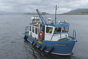
The island is connected to the mainland by two ferries. One is a Caledonian MacBrayne vehicle ferry that goes to Oban. The other is a council passenger ferry that makes a shorter trip from Point, on the northeast tip of the island, to Port Appin. The B8045 is the main road on the island. It runs from the southwest to Point in the northeast.
Lismore has a shop that also serves as a post office, and a café. You can rent bicycles at Point. Explore Lismore offers Land Rover tours and the island's only taxi service. There is no petrol station. In 2001, 29% of the island's people spoke Gaelic. The Comann Eachdraidh Lios Mòr, which is the Lismore Gaelic Heritage Centre, works to keep this language and heritage alive.
Lismore is part of the Oban, Lorn and the Isles ward in the Argyll and Bute council area. The island is represented by Jenni Minto at the Holyrood Parliament in Edinburgh. She was elected for the Argyll and Bute constituency in 2011. Brendan O'Hara represents the island at the Westminster parliament in London.
In 2023, the only shop and post office on the island was at risk of closing. The person running it decided to go back to teaching. The Lismore Community Trust, a local charity, started a campaign to keep it open. With help from residents, holiday home owners, and tourists, they raised more than their goal of £70,000 to save it.
Stories and Traditions: Lismore's Myths and Culture
"The Piper's Cave" is a local story about a piper and his dog. The story says the piper went into a cave called Uamh-Chraidh (the "cave of pain"). He planned to come out through another cave, Uamh-an-duine (the "cave of the man"). People on the island could hear his bagpipes playing. When the music stopped, his dog came out blind and without fur. But the piper was never seen again. People thought he drowned in one of the cave's deep pools.
Another story tells of a boat race between Saint Moluag and Saint Mulhac across the Lynn of Lorn. The first one to land on Lismore would get to build a monastery there. Moluag realized he was losing. So, he cut off his finger and threw it ashore north of the Tirefour broch. This allowed him to claim victory!
The Book of the Dean of Lismore is a very important collection of early Gaelic writings. It was put together by James MacGregor in the 1400s. It is now kept in the National Library of Scotland. However, it was written in Fortingall, which is in Perthshire. So, its connection to Lismore itself is not fully clear.
 | Madam C. J. Walker |
 | Janet Emerson Bashen |
 | Annie Turnbo Malone |
 | Maggie L. Walker |


