
Nave Island facts for kids
| Gaelic name | Eilean Nèimh |
|---|---|
| Meaning of name | "Ném's island" |
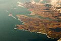
 Nave Island from Ardnave Point with the ruined chapel just visible at left |
|
| OS grid reference | NR292759 |
| Coordinates | 55°54′N 6°20′W / 55.9°N 6.33°W |
| Physical geography | |
| Island group | Islay |
| Area | 40 ha (0.15 sq mi) |
| Area rank | 220= |
| Highest elevation | 34 m (112 ft) |
| Administration | |
| Sovereign state | United Kingdom |
| Country | Scotland |
| Council area | Argyll and Bute |
| Demographics | |
| Population | 0 |
Nave Island is a small, uninhabited island located north of Islay in Scotland's Inner Hebrides. It sits close to the entrance of Loch Gruinart. Even though it's small, Nave Island has an interesting history, especially linked to early Christianity.
Nave Island is almost split in two by a narrow gap. This gap runs from the northwest to the southeast across the northern part of the island. The highest point on the island is about 34 metres (112 ft) above sea level. It is just north of this narrow channel.
To the southwest of Nave Island, you can find several smaller rocks and tiny islands. These include places like Boghachan Mòra and Eilean Beag. There are also the Na Badagan rocks, which are between Nave Island and Ardnave Point on Islay. The Balach Rocks are located to the northeast.
The island covers an area of about 40 hectares (99 acres). This makes it one of the larger small islands in Scotland.
What's in a Name?
The name Nave Island comes from the Scottish Gaelic name Eilean Nèimh. Experts believe it means "Ném's island." It is thought to be named after an early Christian saint called Nem. There were a few saints with this name, so it's not certain which one the island is named after.
Another idea is that the nearby Ardnave Point means "height of the saint." This suggests a more general connection to holy people.
Nave Island has signs of early Christian activity. A large carved Celtic cross was found nearby at Kilnave. A piece of another cross was found on the island itself. These crosses suggest that organized Christianity was present here a very long time ago.
There is also a ruined chapel on the island. It sits just south of the narrow gap that almost cuts the island in two. An old earthen wall around the chapel suggests it might have been a monastery. A book from the late 600s, called Vita Columbae, mentions a monastery on an island called Elena Insula. This might be Nave Island.
In 1549, a writer named Dean Monro described the island. He wrote that it was called Ellan-nese and had a church. He also said it was about half a mile long, good for farming, and good for fishing. Later, in 1654, a map called Blaeu's Atlas referred to the island as "Ylen Naomh."
At the end of the 1600s, Martin Martin listed seven churches on Islay. One of these was a chapel on Nave Island.
In the late 1700s, there was a time when making kelp was very important for the economy of the Hebrides. Kelp is a type of seaweed that was used to make chemicals. While this industry was big in other places, it wasn't as important on Islay. The kelp industry suddenly stopped in Scotland around 1830. This happened after new rules removed taxes on imported chemicals. Today, the only major signs of the kelp industry on Islay are an old furnace and traces of kilns on Nave Island.
Images for kids
-
Loch Gruinart and northwest Islay from the air with Ardnave Point and Nave Island at left centre

