
Peeblesshire facts for kids
Quick facts for kids
Peeblesshire
|
|
|---|---|
 |
|
| Country | Scotland |
| County town | Peebles |
| Area | |
| • Total | 548 sq mi (1,419 km2) |
| Ranked 16th of 34 | |
| Chapman code |
PEE
|
Peeblesshire (which is Siorrachd nam Pùballan in Scottish Gaelic) is also known as the County of Peebles or Tweeddale. It is a historic county located in Scotland. The main town of Peeblesshire is Peebles. This area shares its borders with Midlothian to the north, Selkirkshire to the east, Dumfriesshire to the south, and Lanarkshire to the west.
Contents
History of Peeblesshire
The exact start of Peeblesshire is not fully clear. It became a "shire" (an old word for a county or administrative area) around the 1100s. It covered part of an older region called Tweeddale.
The southern part of Tweeddale became a sheriffdom (an area managed by a sheriff) called Selkirkshire. The northern part was first split into two sheriffdoms, one at Peebles and one at Traquair. Around 1304, these two joined to form the single shire of Peebles, or Peeblesshire. Over time, these shires became the main way Scotland was managed.
Local Government Changes
In 1890, the Local Government (Scotland) Act 1889 created elected county councils across Scotland. This led to the formation of the Peeblesshire County Council. Their first meeting was on May 22, 1890, at the courthouse in Peebles. This building was also known as County Hall. It was built between 1844 and 1848.
.jpg)
The county council stayed at the courthouse until 1935. Then, they moved to a new building called County Buildings on Rosetta Road in Peebles.

In 1975, the Peeblesshire County Council was ended by the Local Government (Scotland) Act 1973. This law changed how local government worked in Scotland. Peeblesshire became part of the Borders region. It also became part of the Tweeddale district, which had the same borders as the old Peeblesshire county. The last lord-lieutenant (a representative of the monarch) for Peeblesshire became the first Lord Lieutenant of Tweeddale.
In 1996, the Borders region and its four districts, including Tweeddale, were combined. They formed the single Scottish Borders council area we know today. The area that was once Peeblesshire is still used as a special ceremonial area called a lieutenancy area under the name Tweeddale.
Symbols of Peeblesshire
Coat of Arms
A coat of arms is a special design used to represent a family, city, or county. Peeblesshire received its own coat of arms in 1931. It has a shield divided into four parts.
- The first part shows five silver strawberry leaves on a black background. These represent the Clan Fraser, an important local family.
- The second part has a silver horse's head on a blue background. This symbol comes from the Horsburgh family, another key local family.
- The third part shows a golden fleece (sheep's wool) on a green background. This represents the area's important wool industry.
- The fourth part has a red criss-cross pattern on gold, with two thunderbolts on a red, castle-like top edge. This part is from the arms of M. G. Thorburn, who was a sheriff in Peebles at the time.
The shield is held up by two salmon fish. Above the shield is a "crest," which is a Border cavalryman (a soldier on horseback). The motto for Peeblesshire is ONWARD TWEEDDALE.
Geography of Peeblesshire
Peeblesshire is a "landlocked" county, meaning it has no coastline. It is part of the Southern Uplands, a hilly region in Scotland. The county has few large towns and is mostly made up of low hills.

Some of the hills here include parts of the Pentland Hills and Moorfoot Hills. The highest point in Peeblesshire is Broad Law, which stands at 840 meters (2,760 feet) tall.

The most important river is the river Tweed, which flows in a curved shape through the county. There are also several bodies of water, including:
- Baddinsgill Reservoir
- West Water Reservoir
- Portmore Loch (in the north)
- Megget Reservoir
- Talla Reservoir
- Fruid Reservoir (in the south)
Transport in Peeblesshire
Peeblesshire used to have railway lines, including the Peebles Railway and the Symington, Biggar and Broughton Railway. However, these lines closed in the 1950s and 1960s. Today, there are no active railways in the county.

Towns and Villages
Here are some of the towns and villages in Peeblesshire:
- Blyth Bridge
- Broughton
- Cardrona
- Carlops
- Drumelzier
- Eddleston
- Innerleithen
- Kilbucho
- Kingledoors
- Kirkbryde
- Lyne
- Mossfennan
- Peebles
- Polmood
- Romannobridge
- Skirling
- Stanhope
- Traquair
- Tweedsmuir
- Walkerburn
- West Linton
Civil Parishes
A civil parish is a local administrative area, often based on older church parishes. Here are the civil parishes in Peeblesshire:

- Broughton, Glenholm and Kilbucho (these three joined in 1794)
- Drumelzier
- Eddleston
- Innerleithen
- Kirkurd
- Linton or West Linton
- Lyne (Megget, an older parish, joined Lyne in 1621 but was moved to Selkirkshire in 1891)
- Manor
- Newlands
- Peebles
- Skirling
- Stobo
- Traquair
- Tweedsmuir (separated from Drumelzier in 1643)
The parish of Kailzie existed until 1674. After that, parts of it became part of Innerleithen and Traquair.
Community Councils
Community Councils are groups of local people who work to improve their area. Here are the Community Councils in Peeblesshire:
- Carlops
- Eddleston
- Innerleithen and District
- Lamancha, Newlands and Kirkurd
- Manor, Stobo and Lyne
- Royal Burgh of Peebles and District
- Skirling
- Tweedsmuir
- Upper Tweed
- Walkerburn
- West Linton
Gallery
-
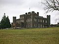
Stobo Castle
-

Innerleithen
-
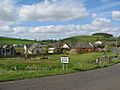
Blyth Bridge
-
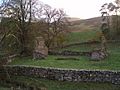
Ruins of Kilbucho Church
-
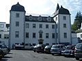
Barony Castle in Eddleston, which contains the Great Polish Map of Scotland
-
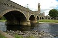
Bridge over the Tweed at Peebles, the county town
-
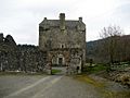
Neidpath Castle in Peebles


