
Great Polish Map of Scotland facts for kids
The Great Polish Map of Scotland is a huge, three-dimensional model of Scotland. It's made of concrete and is located outdoors at the Barony Castle Hotel near Eddleston in the Scottish Borders. This amazing map is about 50 meters long and 40 meters wide! That's like half a football field! It's also known as the Mapa Scotland (which means 'Map of Scotland' in Polish) or the Barony Map.
The idea for this map came from a Polish war veteran named Jan Tomasik. It was built between 1974 and 1979. Many people believe it's the world's largest model of land with hills and valleys. This special sculpture is now a protected building, and a group called Mapa Scotland has worked hard to restore it.

Contents
Why the Map Was Built

The Barony Castle Hotel has a special connection to Polish soldiers during World War II. In 1942, the hotel was used as a main training college for Polish officers in Scotland.
After France was taken over in 1940, the Polish Army in Scotland was reorganized. They were given the important job of defending a long part of Scotland's east coast from a possible invasion by Germany. The Polish soldiers made the defenses stronger by adding obstacles, building small forts, and patrolling the coast.
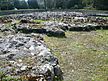
.jpg)
Later, in 1942, the 1st Polish Armoured Division was formed. These Polish troops, led by General Stanisław Maczek, trained in different parts of Scotland. They later played a very important role in the Normandy landings in 1944. They helped win key battles and free parts of the Netherlands from German control.
After the war, many Polish soldiers, including General Maczek, did not want to return to Poland because it was under Communist rule. They settled in Britain, especially in Scotland.
Jan Tomasik, who was a sergeant in the 1st Armoured Division, bought the Barony Castle Hotel in 1968. He had been stationed nearby during the war. General Maczek, like many Polish veterans, faced difficulties after the war. Tomasik helped him by giving him jobs at his hotel.
The idea for the large concrete map of Scotland (which doesn't include the far-off Northern Isles) came from Jan Tomasik. It's not fully clear why he built it. He was fascinated by a large model map of Belgium he saw at a big fair in Brussels in 1958. This map likely inspired him.
Tomasik also saw the map as a way to attract more guests to his hotel. But he also said he wanted to show the country that the Poles had defended during the war. He called it "a gift to the Scottish people" to thank them for their kindness to the Poles during the war. Tomasik passed away in 1991.
How the Map Was Built
,_Barony_Castle.JPG)
The map was designed by Dr. Kazimierz Trafas, a young map expert from the Jagiellonian University in Krakow, Poland.
Jan Tomasik talked about his map idea with Professor Klimaszewski, a geography expert at Jagiellonian University. Professor Klimaszewski gave the job to Dr. Trafas.
The map took six summers to build, from 1974 to 1979. In 1974, Dr. Trafas came to Scotland with a colleague. They surveyed the area and marked out the map's outline. The map was built to a scale of 1:10,000. This means every 1 centimeter on the map represents 100 meters in real life. The shapes of the land and islands were made using wooden frames. The different heights of the land (like hills and valleys) were marked using layers of bricks.
The next summer, Tomasik brought Dr. Trafas and other workers from Krakow University to Scotland. They did the hard work of building the concrete map. Hotel staff also helped. The map was slowly built up by filling the outlines with cement. Mountain tops were marked with vertical rods. Their heights were made to look five times taller than they would be at the map's scale. This made the mountains look more dramatic and real. The land shapes were then carefully sculpted by hand.
After the Polish mapmakers left in 1977, hotel employees and Tomasik's family continued working on the map for two more summers. It was finished in 1979. The surface was painted to show forests, cities, roads, and lochs. A wall was built around the map to create a basin about 1.5 meters deep. Water from a nearby stream was used to fill this basin, creating the seas and lochs. The water also flowed through pipes to create the major rivers.
Professor Trafas, the main designer and builder, passed away in 2004.
Restoring the Map
After the hotel was sold in 1985, parts of the map slowly started to wear out. Even though most of it was still strong, some concrete became weak. In 2010, a group of volunteers called Mapa Scotland was formed. They worked to get the map recognized as a category B listed building by Historic Scotland in 2012.
Their goal is to fix the map and make it look like new again. They also want to promote it as an important historical site, a learning tool, and a place for visitors. In 2011, they received a grant of £20,000 from the Heritage Lottery Fund. They also raised more money from the Barony Castle Hotel and other groups.


The Polish Consul General in Scotland, Tomasz Trafas (who is Professor Trafas's brother), said that the map is "a rare symbol" of the long-standing cultural connections between Poland and Scotland. He believes it's important to save it for everyone to enjoy.
In May 2012, Christine Grahame, a Member of the Scottish Parliament (MSP), suggested that the Scottish Parliament should recognize the map's importance. This motion was discussed in September 2012.
How Big Is It?
The Great Polish Map of Scotland is about 50 meters long and 40 meters wide. It's much bigger than other similar maps around the world. For example, it's 2.8 times larger than a terrain model of British Columbia that was once claimed to be the biggest. The "land" part of the Great Polish Map of Scotland alone covers 780 square meters.
Gallery
-
Forth Estuary and Fife
-
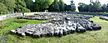
The map being prepared for restoration


See also
 In Spanish: Gran mapa polaco de Escocia para niños
