
River Tweed facts for kids
Quick facts for kids River Tweed |
|
|---|---|

The River Tweed at Abbotsford
|
|
| Country | United Kingdom |
| Part | Scotland, England |
| Physical characteristics | |
| Main source | Tweed's Well Tweedsmuir, Scottish Borders, Scotland 55°26′42″N 3°29′46″W / 55.445°N 3.496°W |
| River mouth | North Sea Berwick-upon-Tweed, Northumberland, England 55°45′55″N 1°59′27″W / 55.7652°N 1.9909°W |
| Length | 156 km (97 mi) |
The River Tweed, also known as Tweed Water, is a river about 97 miles (156 km) long. It flows east across the border region between Scotland and northern England. The famous Tweed cloth gets its name from this river.
The Tweed is one of the best rivers in Britain for catching salmon. It's so special that people from all over the world come here to fish. The name Tweed comes from an old Celtic word meaning "border".
Where the River Tweed Flows

The River Tweed mainly flows through the beautiful Borders area of Scotland. As it moves east, it forms part of the historic boundary between Scotland and England, especially near the towns of Birgham and Carham.
The river starts high up in the Lowther Hills at a place called Tweed's Well. Interestingly, two other major rivers, the Clyde and the Annan, also begin very close by. There's a saying in the Border region: "Annan, Tweed and Clyde rise oot the ae hillside" (meaning they all rise from the same hillside).
East of Kelso, the Tweed becomes a section of the border itself. Finally, it enters England in Northumberland and flows into the North Sea at Berwick-upon-Tweed.
Towns and Tributaries
The valley floor of the River Tweed was shaped by ancient ice streams during the last Ice Age. Many important towns are located along the Tweed's path. These include Innerleithen, Peebles, Galashiels, Melrose, Kelso, Coldstream, and Berwick-upon-Tweed.
Many smaller rivers and streams, called tributaries, flow into the Tweed. Some of these are:
- Whiteadder Water
- River Till
- Eden Water
- Teviot Water
- Leader Water
- Gala Water
- Leithen Water
- Quair Water
- Eddleston Water
- Manor Water
- Lyne Water
- Holms Water
The upper part of the Tweed's area in Scotland is known as Tweeddale. Part of this area is a protected place called the Upper Tweeddale National Scenic Area. This is one of 40 such areas in Scotland. They are special places known for their amazing scenery and are protected from building too much.
Images for kids
-
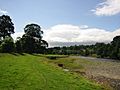
The River Tweed at Abbotsford, near Melrose
-
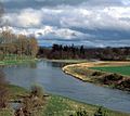
The River Tweed from Mertoun House, near St Boswells
-
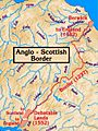
The Anglo-Scottish border, with the Tweed on the east. Its estuary and the town of Berwick-upon-Tweed were a late annexation by England.
-
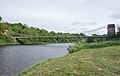
The Union Chain Bridge crossing the Tweed between Horncliffe, England and Fishwick, Scotland


See also
 In Spanish: Tweed (río) para niños
