Upper Tweeddale National Scenic Area facts for kids
Quick facts for kids Upper Tweeddale National Scenic Area |
|
|---|---|

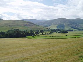
Farmland in the valley of the Manor Water.
|
|
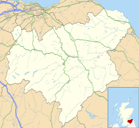
| Location | Scottish Borders, Scotland |
| Area | 128 km2 (49 sq mi) |
| Established | 1981 |
| Governing body | NatureScot |
The Upper Tweeddale National Scenic Area is a very special place in the Scottish Borders region of Scotland. It is one of 40 "national scenic areas" (NSAs) across Scotland. These areas are chosen because they have incredibly beautiful scenery. The goal is to protect them from building projects that might spoil their natural look.
This protected area covers about 12,770 hectares (which is about 49 square miles). It includes the upper parts of the River Tweed and the countryside around it. This area stretches between the villages of Broughton and Peebles.
National scenic areas are mainly picked for their amazing views. But sometimes, they are also chosen for their history, old buildings, geology (the rocks and land), or wildlife. Other special protections might also cover these areas. For example, the Upper Tweeddale NSA includes two Sites of Special Scientific Interest (SSSIs). These are places with important plants, animals, or geological features.
Even though being a national scenic area helps protect the land, there isn't a special group like a national park authority to manage it. Local councils, like the Scottish Borders Council, can create plans to look after these areas.
Why Was This Area Protected?
After the Second World War, a group was set up to think about how to protect Scotland's beautiful landscapes. In 1945, they suggested that five areas should be specially protected. These were places like Loch Lomond and the Cairngorms.
Later, in 1978, another review looked at more areas. The Upper Tweeddale area was identified as a place with very special scenery that needed protection. So, in 1981, the "national scenic area" name was created. This new protection included the Upper Tweeddale area, based on the 1978 suggestions. The boundaries of the area are still the same as they were first drawn in 1978. New laws in 2010 simply confirmed its protected status.
What Does Upper Tweeddale Look Like?
The report from 1978 described the area beautifully. It said the upper part of the River Tweed flows through a narrow valley. This valley has steep sides and is surrounded by rounded hills. The valley feels enclosed, but it's also very interesting.
You can see a mix of woodlands, from rows of trees to large forests. There's also farmland, which changes from rough grazing land on the hills to fields for crops and riverside meadows. The valley gets wider where smaller rivers like the Holm, Lyne, and Manor Waters join the Tweed. This gives you longer views into those smaller valleys and towards the higher hills.
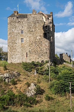
Then, the valley narrows again at a place called Neidpath. Here, Neidpath Castle stands guard over a narrow pass. The river itself is a big part of the scenery. It winds through its flat riverside lands, looking grander than it really is. The valley is also dotted with old castles, large houses, churches, and busy farmhouses. The hills show many signs of ancient people who lived there long ago.
Some interesting historical spots in the area include the old hill fort at Dreva Craig and Barns Tower. You can also find castles at Stobo, Neidpath, and Tinnis. If you like walking, the John Buchan Way is a 22-kilometer (13.7-mile) path. It goes between Broughton and Peebles and passes right through this beautiful area.
Protecting Nature in Upper Tweeddale
The River Tweed and its smaller rivers, like the Manor Water and Holm Water, are very important. They are part of a Special Area of Conservation (SAC). This means they are protected because they are home to important populations of fish like salmon, brook lamprey, river lamprey, and sea lamprey. Otters also live here.
The river has many different types of plants and animals. This is because the rocks and soil in the area are very varied. The river is also a Site of Special Scientific Interest (SSSI). This is another way to protect its special natural features.
Another SSSI within the Upper Tweeddale NSA is the Tweedsmuir Hills. These hills have the largest area of mountain plateau in Scotland outside of the Highlands. They are important for many reasons. They are home to nationally important groups of breeding birds. You can also find rare mosses, liverworts, and special arctic–alpine plants that usually grow in very cold places.
Finally, the gardens around Barns Tower and Stobo Castle, along with Dawyck Botanic Garden, are listed in the "Inventory of Gardens and Designed Landscapes in Scotland." This means they are recognized for their special design and beauty.
 | John T. Biggers |
 | Thomas Blackshear |
 | Mark Bradford |
 | Beverly Buchanan |


