Blackadder Water facts for kids
Quick facts for kids Blackadder Water |
|
|---|---|

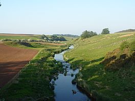
Blackadder Water below Greenlaw
|
|
| Location | Scottish Borders |
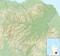
| Coordinates | 55°45′14″N 2°33′11″W / 55.754°N 2.553°W |
| Basin countries | Scotland |
The Blackadder Water is a river that flows through the Scottish Borders area of Scotland. It is an important part of the larger River Tweed system.
On October 22, 2002, the river reached its highest recorded level at Mouthbridge. It measured 2.84 meters (about 9 feet, 4 inches) deep at that time.
What's in a Name?
The name Blackadder might come from old words meaning "a watercourse" or "a channel." Some experts think it comes from an ancient British language. Others suggest it comes from an old English word.
There's also a theory that the name comes from the Gaelic phrase fad dûr. This phrase means "long water."
Where Does It Flow?
The Blackadder Water begins in the Harecleugh Forest plantation. This area is just south of the Twin Law cairns, near the village of Westruther.
As it starts its journey, smaller streams join the Blackadder. These include the Wedderlie, Edgar, and Fangrist Burns. The river then flows towards the town of Greenlaw.
The river takes a winding path through an area called the Merse. It then meets the Langton Burn between the estates of Kimmerghame House and Wedderburn Castle.
Later, the Blackadder Water becomes a tributary of the Whiteadder Water. They join together near the village of Allanton. This is where the historic Blackadder House and its estate once stood.
The Whiteadder Water then crosses into England below Edrington. Finally, it joins the mighty River Tweed. The Tweed then flows into the North Sea at Berwick-upon-Tweed.
 | James Van Der Zee |
 | Alma Thomas |
 | Ellis Wilson |
 | Margaret Taylor-Burroughs |


