Hart Fell facts for kids
Quick facts for kids Hart Fell |
|
|---|---|
 |
|
| Highest point | |
| Elevation | 808 m (2,651 ft) |
| Prominence | 200 m (660 ft) |
| Listing | Ma,Hu,Tu,Sim, C, D,DN,Y |
| Naming | |
| English translation | Hill of the Red Deer |
| Geography | |
| Location | Dumfries and Galloway, Scottish Borders, Scotland |
| Parent range | Moffat Hills, Southern Uplands |
| OS grid | NT 11366 13570 |
| Topo map | OS Landranger 78 |
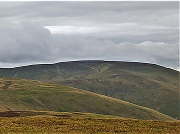
Hart Fell is a cool hill located in the Moffat Hills. This mountain range is part of the Southern Uplands in beautiful Scotland. It sits just north of the town of Moffat.
Hart Fell is special because it's right on the border. It separates the areas of Scottish Borders and Dumfries and Galloway. Its name means "Hill of the Red Deer," which sounds pretty awesome!
Exploring Hart Fell
Hart Fell is a big, rounded hill. You can easily spot it from the M74 motorway to the west. You can also see parts of it from Dumfries and other areas to the east.
Most sides of Hart Fell have gentle slopes. This makes it a bit easier to climb. However, the eastern side is quite different. It has steep, rocky cliffs.
Blackhope Corrie
On the eastern side, you'll find a deep, bowl-shaped hollow. This is called a corrie, and this one is known as Blackhope. Corries are often formed by glaciers long ago. They look like giant scoops taken out of the mountain.
Popular Walking Routes
Many people enjoy hiking up Hart Fell. The most common way to reach the top is from the southern side. This path takes you over another hill called Swatte Fell first.
The Hart Fell Horseshoe
For a longer adventure, hikers can do something called the "Hart Fell Horseshoe." This route makes a full loop around the Blackhope corrie. It finishes by climbing another peak called Saddle Yoke. It's a challenging but very rewarding walk!
 | Aaron Henry |
 | T. R. M. Howard |
 | Jesse Jackson |

