Northwest Philadelphia facts for kids
Quick facts for kids
Northwest Philadelphia
|
|
|---|---|

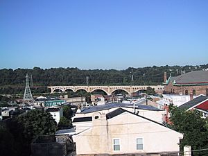
Manayunk skyline in the Roxborough-Manayunk district in Northwest Philadelphia
|
|

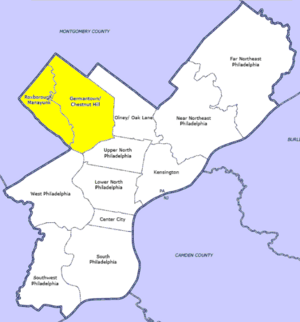
Map of Philadelphia County with Northwest highlighted neighborhood. Click for larger image.
|
|
| Country | |
| State | |
| County | |
| City | |
| Population
(2010)
|
|
| • Total | ~170,000~ |
| ZIP codes |
19118, 19119, 19127, 19128, 19129, 19138, 19144, 19150
|
Northwest Philadelphia is a cool part of the big city of Philadelphia. It has clear borders: Stenton Avenue to the north, the Schuylkill River to the southwest, and Northwestern Avenue to the northwest. To the south, you'll find Roosevelt Boulevard, and Wister Street and Stenton Avenue are to the east.
This area is split into two main parts by the Wissahickon Creek. The 'Upper Northwest' includes neighborhoods like Germantown, Mount Airy, Chestnut Hill, and Cedarbrook. The 'Lower Northwest' has places like Roxborough, Wissahickon, East Falls, and Manayunk. The area of Philadelphia west of the Schuylkill River is known as West Philadelphia. The Philadelphia Police Department helps keep the area safe, with two special districts covering Northwest Philadelphia.
Contents
People and Culture
Northwest Philadelphia is home to many different groups of people. You'll find African American, Irish-American, Jewish-American, German-American, and Italian-American families here. Each smaller neighborhood might be known for one group more than others, making the culture very diverse.
In 2011, the population of Northwest Philadelphia changed a bit. Back in 1990, about half of the people living here were African American.
A Mix of City and Suburban Life
Compared to other parts of Philadelphia, a lot of Northwest Philadelphia feels more like a suburb. For example, in East Falls, you can see large Tudor-style homes and modern ranch houses with big yards. Just a few blocks away, you might find smaller townhouses and rowhouses.
Upper Roxborough has newer housing developments built after World War II. Lower Roxborough mostly has rowhouses, twin houses, and apartments above shops. You can also spot blocks with large Victorian homes mixed in with the rowhouses.
This area is a cool mix of old and new. Some buildings and streets are hundreds of years old, while other spots were farmland until recently. You might see 18th-century farmhouses next to 19th-century rowhouses and 20th-century shopping centers. From working-class rowhouses in Germantown to the fancy estates in Chestnut Hill, homes built between 1880 and 1920 show this interesting blend.
Hills and Rivers: The Landscape
Northwest Philadelphia is famous for its many hills. This is especially true in the western half, between the Wissahickon Creek and the Schuylkill River. These hills are a big reason why places like Manayunk and Roxborough are popular for outdoor fun. Think sledding, soapbox derbies, or challenging runs and bike rides!
Upper Roxborough is one of the highest spots in Philadelphia. Because of this, it's where you'll find a big water reservoir and many of the city's broadcast towers. Ridge Avenue follows a natural ridge that separates the Wissahickon valley from the Schuylkill valley. A beautiful place called Wissahickon Valley Park is also located in Northwest Philadelphia.
How the Streets Are Laid Out
The streets in Northwest Philadelphia are set up in a unique way. They mostly run from northeast to southwest and from northwest to southeast. This means they are turned almost exactly 45 degrees from the usual north-south and east-west streets you might see in other parts of Philadelphia.
The Wissahickon gorge acts like a natural divider between the two 'halves' of Northwest Philadelphia. There aren't many roads that cross it, which makes it a clear separation. Train tracks also tend to divide neighborhoods for the same reason. The street layout in Manayunk, for example, developed completely on its own, separate from how Germantown's streets were planned.
 | Ernest Everett Just |
 | Mary Jackson |
 | Emmett Chappelle |
 | Marie Maynard Daly |

