
Wissahickon, Philadelphia facts for kids
Quick facts for kids
Wissahickon
|
|
|---|---|

Wissahickon neighborhood gateway sign
|
|
| Country | |
| State | Pennsylvania |
| County | Philadelphia County |
| City | Philadelphia |
| Zipcode |
19128
|
| Area code(s) | 215, 267 and 445 |
Wissahickon is a neighborhood in the Lower Northwest Philadelphia area of Pennsylvania, United States. It's located next to the neighborhoods of Roxborough and Manayunk. The area is bordered by the Wissahickon Valley Park, Ridge Avenue, Hermit Street, and Henry Avenue.
The name "Wissahickon" comes from the Lenni Lenape word wisameckham. This word means "catfish creek." It refers to the many catfish that used to live in the Wissahickon Creek.
Contents
History of Wissahickon
The village of Wissahickon was started in the late 1800s. It was founded by leaders of the Pencoyd Iron Works. Starting in the 1880s, many mill owners and rich business people from nearby Manayunk wanted fancy homes. They looked at land along the Wissahickon Creek. This land was owned by important Philadelphia families.
Large, beautiful homes were built there. These homes had big yards. This created a "unique park side Victorian wonderland." Wissahickon became a very popular place to live. It was close to the Wissahickon Valley. It also had tree-lined streets and new water services.
Historic Buildings and Places
Wissahickon is home to several important historical sites. These places tell stories about the neighborhood's past.
The 100 Steps
- The 100 Steps: These wide stairs are at the bottom of Freeland Avenue. They were built in 1901. The stairs are made of Wissahickon granite and local iron. They were fixed up between 2003 and 2005. The 100 Steps make it easy to get to the trails in Wissahickon Valley Park.
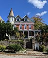
Important Houses in Wissahickon
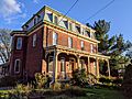
- Amos Barnes House: This house is at 559 Righter Street. It was built around 1856. It's made of Wissahickon schist rock. The house belonged to Amos Barnes, an architect. He designed the Plays and Players Theatre in Philadelphia. He also designed an addition to the Wissahickon Presbyterian Church. In 2017, the house was named a historic place. Plans to fix it up and add a new building were approved in 2022.
- Holt House: Located at 145 Sumac Street, this house was built around 1884. It was owned by James Z. and Mary Holt. They were important people in Philadelphia. James was a mill owner and banker. This house was one of the first big homes built in Wissahickon. It was meant for wealthier people. In 2015, there were plans to tear it down. But an agreement was made to save and fix up the house.
- James Sibbald House: This house is at 5201 Ridge Avenue. It was built around 1890. Dr. James Sibbald, a local surgeon, owned it. The house was designed by architect Daniel S. Beale.
- Maurice Wilhere House: This house is at 147 Sumac Street. It was built around 1884. Maurice F. Wilhere, a local leader, owned it. This house is a twin to the Holt House. It was also one of the first large homes built in the area.
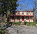
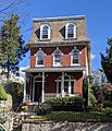
- William Paine House: This house is at the corner of Vicaris Street and Osborn Street. It was built around 1869. It was added to the Philadelphia Register of Historic Places in 1993. William Paine was a doctor.
Other Historic Buildings
- Merrick Hall: This building is on the 5300 block of Ridge Avenue. It's the oldest building on the Northern Children’s Services campus. It was built in the 1860s. It was once the home of J. Vaughan Merrick, a rich business owner. The building has been renovated several times.
- Northern Children's Services: Also on the 5300 block of Ridge Avenue, this is a group of stone buildings. They were designed in 1927 to help children and families.
- The Ridge Avenue Bridge: This stone bridge is at the south end of the neighborhood. It was built in 1888. It carries Ridge Avenue over the Wissahickon Creek. It was added to the National Register of Historic Places in 1988.
- St. Timothy's Workingmen's Club and Institute: This building is at the intersection of Ridge Avenue, Terrace Street, and Vassar Street. It was founded in 1872. It was built to offer social and educational chances for working men. It had a library, reading rooms, and classes. The club closed in 1912. The building was added to the Philadelphia Register of Historic Places in 1974.
- Wissahickon Presbyterian Church: This church is at the corner of Ridge Avenue, Dawson Street, and Manayunk Avenue. It was built in 1893. It has a mix of Gothic and Renaissance styles.
Population and Community
The Wissahickon neighborhood had about 3,163 people living there in 2010. There were about 1,520 households. Most residents (about 87.5%) were White/Caucasian. About 6.3% were Black or African-American. About 15% of households had children under 18.
Most residents were young adults. About 44% were between 18 and 34 years old. About 12.6% were under 18 years old.
Education in Wissahickon
Schools for Kids


The School District of Philadelphia runs the public schools. Cook-Wissahickon School is for grades K-8. It was built in 1968. It replaced the older Cook Public School and Wissahickon School. The old Wissahickon School was built in 1887. It is now the site of LaNoce Park. Students from Cook-Wissahickon usually go to Roxborough High School.
Public Libraries
The Free Library of Philadelphia has a branch nearby. The Roxborough Branch serves Wissahickon. It is located at 6245 Ridge Avenue.
There was an earlier library called the Wissahickon Branch. It opened in 1909. It was built on land given by the Pencoyd Iron Works. This library was funded by Andrew Carnegie. It had a main reading room and a children's room. The Wissahickon Branch closed in 1969. The building later burned down.
Parks and Fun Activities
Wissahickon offers great places for outdoor activities.
- David P. Montgomery Field: This park was once called Daisy Field. It is named after David Montgomery. He was a former president of the Philadelphia Phillies baseball team.
- LaNoce Park: This park is bordered by Osborn Street, Rochelle Avenue, and Kalos Street. It's where the old Wissahickon School used to be. The park was created in 1984. It was named after Sabatina LaNoce. He was a local barber and community leader.
- Wissahickon Valley Park: This is a huge park, about 1,800 acres. It surrounds the Wissahickon Creek. It has about 50 miles of trails for biking, hiking, and horse riding. The park started in 1867. The City of Philadelphia owns it. The Friends of the Wissahickon group helps take care of the park.

Getting Around Wissahickon


Ridge Avenue is a very old and long road. It runs along the edge of Wissahickon.
One train line connects the neighborhood to Center City. It's the Manayunk/Norristown Line. The train stops at the Wissahickon station. The original station building was designed by a famous architect, Frank Furness, but it was later taken down. Improvements have been made to the station. In 2016, an artist painted a mural there.
The neighborhood also has bus routes 9, 27, and 65. The Wissahickon Transportation Center is a hub for many bus routes. Plans to update this center were shared in 2018. These plans include expanding the station and adding new shops and apartments.
Community Groups
The main local community group is the Wissahickon Interested Citizen's Association (WICA). This group has helped protect the neighborhood's look and feel. They work to manage new building projects. They also help keep the area easy to walk around. Public meetings are held every second Wednesday of the month.
Another group is the Wissahickon Neighbors Civic Association (WNCA). They serve the area northwest of Ridge Avenue. Their public meetings are held every third Thursday of the month.
Images for kids
-
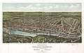
Birds Eye View of Manayunk, Wissahickon, Roxborough from West Laurel Hill Cemetery, 1907
-
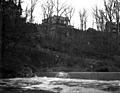
View of the 100 steps from the Wissahickon Creek, 1907
-
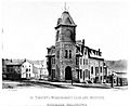
St. Timothy's Workingmen's Club and Institute, 1878
-
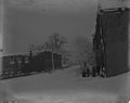
Snow scene, 100 block of Kalos Street, 1907
-
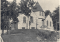
Wissahickon Presbyterian Church, 1895
-
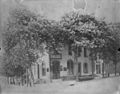
Sarah A. Wright's ale, porter & lager beer saloon, 5226 Ridge Avenue, 1907
-
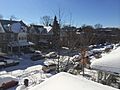
Rochelle Avenue on a snowy day, 2014
-
William Paine House, 2020
-
Albanus Harmer House, 2020
-
Eugene Kaiser House, 2020
-
H. Rother and A.F. Hoffman Twin, 2020


_(graphic).jpg)


