Whitpain Township, Pennsylvania facts for kids
Quick facts for kids
Whitpain Township
|
|||
|---|---|---|---|
|
Township
|
|||

|
|||
|
|||

Location of Pennsylvania in the United States
|
|||
| Country | United States | ||
| State | Pennsylvania | ||
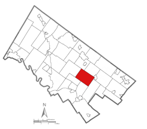
| County | Montgomery | ||
| Area | |||
| • Total | 12.86 sq mi (33.3 km2) | ||
| • Land | 12.85 sq mi (33.3 km2) | ||
| • Water | 0.01 sq mi (0.03 km2) | ||
| Elevation | 259 ft (79 m) | ||
| Population
(2010)
|
|||
| • Total | 18,875 | ||
| • Estimate
(2016)
|
19,308 | ||
| • Density | 1,467.7/sq mi (566.69/km2) | ||
| Time zone | UTC-5 (EST) | ||
| • Summer (DST) | UTC-4 (EDT) | ||
| Area code(s) | 610, 484 | ||
| FIPS code | 42-091-84888 | ||
Whitpain Township is a community located in Montgomery County, Pennsylvania, United States. It was established in 1701. According to the 2010 census, about 18,875 people live there.
Contents
Where is Whitpain Township?
Whitpain Township covers an area of about 12.9 square miles. Only a tiny part of this area, about 0.08%, is water. The township is roughly four and a half miles long and three miles wide.
There are two main watersheds in the township. These are areas where all the rain and water flow into a common stream or river. The two watersheds here are Wissahickon Creek and Stony Creek. Wissahickon Creek was even known as "Whitpaine's Creek" a long time ago!
Who Lives in Whitpain Township?
| Historical population | |||
|---|---|---|---|
| Census | Pop. | %± | |
| 1930 | 2,328 | — | |
| 1940 | 2,451 | 5.3% | |
| 1950 | 3,063 | 25.0% | |
| 1960 | 7,331 | 139.3% | |
| 1970 | 9,245 | 26.1% | |
| 1980 | 11,772 | 27.3% | |
| 1990 | 15,673 | 33.1% | |
| 2000 | 18,562 | 18.4% | |
| 2010 | 18,875 | 1.7% | |
| 2020 | 20,333 | 7.7% | |
| U.S. Decennial Census | |||
In 2010, most of the people living in Whitpain Township were White (80.0%). There were also people who were Black or African American (5.2%), Asian (10.9%), and other backgrounds. About 2.6% of the population had Hispanic or Latino family roots.
Back in 2000, there were 18,562 people living in 6,960 households. A household is a group of people living together in one home. Most households (66.3%) were married couples with families. About 34.0% of households had children under 18. The average household had 2.64 people.
The population was spread out by age. About 25.0% were under 18 years old. The median age, which is the middle age of all the people, was 41 years.
In 2000, the average income for a household was $88,933. For families, it was $103,613. Only a small number of families (1.7%) and people (3.1%) lived below the poverty line.
A Look Back: History of Whitpain Township
Whitpain is one of the oldest townships in Montgomery County. It was named after Richard Whitpaine, a butcher from London. He bought a large piece of land, about 4,500 acres, as part of William Penn’s plan for Pennsylvania.
In 1682, Richard's 16-year-old son, Zechariah, traveled to Pennsylvania with William Penn on a ship called the Welcome. Zechariah came to manage his father's land and to escape being treated unfairly for his Quaker beliefs. By 1685, Zechariah had built a home near Wissahickon Creek.
The township was officially recognized as "Whitpain's Township" in 1701. Its boundaries changed in 1733 when Worcester Township was created. For a short time in 1762, Whitpain and Plymouth Township were combined, but people didn't like it, so they were separated again in 1763.
Whitpain Township started with 24 landowners in 1734. It grew slowly for a long time, from 771 people in 1800 to 3,063 in 1950. Recently, the township has grown much faster. Today, over 18,000 people call Whitpain Township home.
Early Life and Industry
The first people to settle in Whitpain Township were mostly farmers. In 1727, Jacob Yost started a weaving business, bringing industry to the area. Charles Mather built another mill in 1804.
Even though it was a farming community for many years, Whitpain Township has seen a lot of business growth recently. It is now home to several large companies from the Philadelphia area, like Aetna US Healthcare and Unisys.
Churches and the Revolutionary War
While many different religions and nationalities are found in Whitpain Township today, the first settlers were mainly Protestant and Quaker. Before the American Revolutionary War, there were two churches: Boehm's Reformed Church (around 1740) and St. John's Lutheran Church (around 1769).
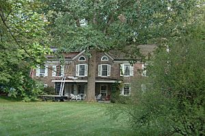
Whitpain Township played a role in the Revolutionary War. George Washington and many of his generals stayed in the township. Dawesfield, a house on Lewis Lane, is a very important historical spot. Washington used it as his headquarters from October 21 to November 2, 1777. Dawesfield was added to the National Register of Historic Places in 1991.
Communities within Whitpain Township
Whitpain Township is made up of several smaller communities. These communities were started both before and after the Revolutionary War. Some of them include West Ambler, Center Square, Blue Bell, Broad Axe, and Washington Square.
Most of Whitpain Township uses the Blue Bell, Pennsylvania ZIP code. Because of this, the name "Blue Bell" has become very well known and is often used to describe much of the township.
Economy: Businesses and Jobs
Whitpain Township is home to the main offices of companies like Unisys and Kappa Publishing Group, both located in Blue Bell.
Top Employers in Whitpain Township
Here are some of the biggest employers in Whitpain Township, based on a 2022 report:
| # | Employer | # of Employees |
|---|---|---|
| 1 | Henkels & McCoy Inc. | 1,002 |
| 2 | Montgomery County Community College | 904 |
| 3 | Pharmaceutical Research Associates | 494 |
| 4 | Aetna | 402 |
| 5 | Hansen Properties | 356 |
| 6 | ICON Clinical Research | 349 |
| 7 | Kencrest Services | 332 |
| 8 | Giant Food Stores | 324 |
| 9 | Siemens | 288 |
| 10 | United Biosource LLC | 256 |
Education in Whitpain Township
The Wissahickon School District provides public education for children in Whitpain Township. This district also serves Lower Gwynedd Township and Ambler Borough.
Within Whitpain Township, there are three elementary schools: Blue Bell Elementary School, Shady Grove Elementary School, and Stony Creek Elementary School. Wissahickon Middle School and Wissahickon High School are located just outside the township.
There is also a college in the township called Montgomery County Community College.
Getting Around: Transportation
As of 2021, Whitpain Township has about 90 miles of public roads. Most of these roads are maintained by the township itself.
The main roads in Whitpain Township are U.S. Route 202 (DeKalb Pike) and Pennsylvania Route 73 (Skippack Pike). These two roads meet in Center Square. While most of these roads have two lanes, U.S. Route 202 is being updated to have four lanes.
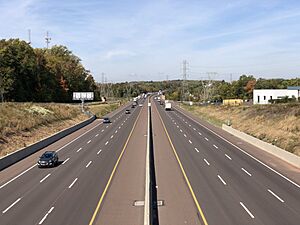
Interstate 476, which is part of the Pennsylvania Turnpike, goes through the township. However, there are no exits or entrances to this highway within Whitpain Township.
The township also has a small airport called Wings Field, which is used for general aviation (private flights).
Several train lines cross the township. While there are no active passenger train stations directly in Whitpain Township, you can find stations in nearby towns like North Wales and Ambler. These stations are served by SEPTA Regional Rail's Lansdale/Doylestown Line. SEPTA also offers bus service in Whitpain Township on routes 94, 95, 96, and 98.
Community Groups
Whitpain Residents Organization
The Whitpain Residents Organization is a community group that started in 2006. It is a non-profit group that aims to encourage "responsible development" and protect the "quality of life" in Whitpain Township. This group became well known for speaking out against a plan to build a hospital on land that used to belong to Unisys.
See also
 In Spanish: Municipio de Whitpain para niños
 | William Lucy |
 | Charles Hayes |
 | Cleveland Robinson |


