Worcester Township, Pennsylvania facts for kids
Quick facts for kids
Worcester Township
|
||
|---|---|---|
|
Township
|
||

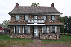
Peter Wentz Homestead, built in 1758
|
||
|
||

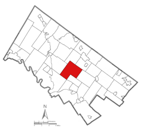
Location of Worcester Township in Montgomery County, Pennsylvania
|
||
| Country | United States | |
| State | Pennsylvania | |
| County | Montgomery | |
| Area | ||
| • Total | 16.22 sq mi (42.0 km2) | |
| • Land | 16.22 sq mi (42.0 km2) | |
| • Water | 0.01 sq mi (0.03 km2) | |
| Elevation | 269 ft (82 m) | |
| Population
(2010)
|
||
| • Total | 9,750 | |
| • Estimate
(2016)
|
10,486 | |
| • Density | 601.1/sq mi (232.09/km2) | |
| Time zone | UTC-5 (EST) | |
| • Summer (DST) | UTC-4 (EDT) | |
| Area code(s) | 610, 484, 215, 267, 445 | |
| FIPS code | 42-091-86496 | |
Worcester Township (pronounced WUR-ses-ter) is a community located in Montgomery County, Pennsylvania, in the United States. A township is a type of local government area. In 2010, about 9,750 people lived here.
Contents
History of Worcester Township
Worcester Township was founded in 1733. It was named after the city of Worcester, England. Over time, it grew to include three smaller villages: Center Point, Cedars Village, and Fairview Village.
Historic Homes and Landmarks
Two important historical buildings in Worcester Township are the Anthony Morris House and the Peter Wentz Homestead. These homes are so special that they are listed on the National Register of Historic Places. This means they are protected because of their historical importance. The Peter Wentz Homestead was built in 1758.
Geography of Worcester Township
Worcester Township covers about 16.2 square miles. Most of this area is land, with only a tiny bit of water. The township is part of the Schuylkill River watershed. This means that water from the area eventually flows into the Schuylkill River.
Local Waterways
The township's water drains into Skippack Creek. This creek then flows into Perkiomen Creek. Another stream, Stony Creek, also helps drain the area.
Worcester Township Villages
Several small villages are part of Worcester Township. These include Bethel Hill, Cedars, Center Point, Fairview Village, Heebnerville, Providence Square, and Worcester.
Neighboring Communities
Worcester Township shares its borders with several other communities. These include:
- Lower Providence Township (to the southwest)
- Skippack Township (to the northwest)
- Towamencin Township (to the north)
- Upper Gwynedd Township (to the northeast)
- Whitpain Township (to the southeast)
- East Norriton Township (to the south)
- West Norriton Township (touching the south edge)
Transportation in Worcester Township
Worcester Township has many public roads. As of 2020, there were over 80 miles of roads. Some roads are maintained by the state, and others by the township itself.
Major Roads and Highways
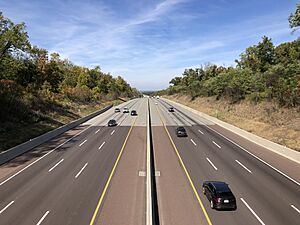
The most important road passing through Worcester Township is Interstate 476. This highway is also known as the Northeastern Extension of the Pennsylvania Turnpike. However, there are no exits for I-476 directly within the township.
The main roads for local travel are Pennsylvania Route 73 and Pennsylvania Route 363. These routes help people get around the township.

Public Transportation Options
SEPTA provides public bus service in Worcester Township. The Route 91 bus runs through the township on Saturdays. It connects the Norristown Transportation Center in Norristown to the State Correctional Institution – Phoenix in Skippack Township.
Population and People
The number of people living in Worcester Township has grown a lot over the years.
| Historical population | |||
|---|---|---|---|
| Census | Pop. | %± | |
| 1930 | 1,487 | — | |
| 1940 | 1,609 | 8.2% | |
| 1950 | 1,939 | 20.5% | |
| 1960 | 3,250 | 67.6% | |
| 1970 | 4,243 | 30.6% | |
| 1980 | 4,661 | 9.9% | |
| 1990 | 4,686 | 0.5% | |
| 2000 | 7,789 | 66.2% | |
| 2010 | 9,750 | 25.2% | |
| 2020 | 10,317 | 5.8% | |
| U.S. Decennial Census | |||
In 2010, the population was 9,750. By 2020, it had grown to 10,317 people.
Diversity in the Township
Worcester Township is home to people from many different backgrounds. In 2010, most residents were White. There were also significant numbers of Asian and African American residents. About 1.6% of the population had Hispanic or Latino family roots.
Household Information
In 2000, there were nearly 2,900 households in the township. Many of these were families with children. The average household had about 2.7 people. The median age of residents was 40 years old.
Education in Worcester Township
Students in Worcester Township attend schools within the Methacton School District.
Local Schools
Most children in the township go to Worcester Elementary School. Some smaller areas are zoned for Eagleville Elementary School. After elementary school, students attend Skyview Upper Elementary School and Arcola Intermediate School. Finally, they go to Methacton High School. These schools serve all parts of the district.
Fun Facts About Worcester Township
- Worcester Township was established in 1733.
- It was named after Worcester, a city in England.
- The township includes the central Schwenkfelder church, which is important to the local community.
See also
 In Spanish: Municipio de Worcester para niños
 | Sharif Bey |
 | Hale Woodruff |
 | Richmond Barthé |
 | Purvis Young |


