
Royersford, Pennsylvania facts for kids
Quick facts for kids
Royersford, Pennsylvania
|
|
|---|---|

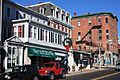
Main Street in Royersford
|
|

Location of Royersford in Montgomery County, Pennsylvania.
|
|

Royersford, Pennsylvania
Location in Pennsylvania

Royersford, Pennsylvania
Location in the United States
|
|
| Country | United States |
| State | Pennsylvania |
| County | Montgomery |
| Incorporated | 1879 |
| Government | |
| • Type | Council-manager |
| Area | |
| • Total | 0.82 sq mi (2.13 km2) |
| • Land | 0.79 sq mi (2.04 km2) |
| • Water | 0.03 sq mi (0.09 km2) |
| Elevation | 239 ft (73 m) |
| Population
(2020)
|
|
| • Total | 4,940 |
| • Density | 6,253.16/sq mi (2,414.36/km2) |
| Time zone | UTC-5 (EST) |
| • Summer (DST) | UTC-4 (EDT) |
| ZIP Code |
19468
|
| Area code(s) | 610 and 484 |
| FIPS code | 42-66576 |
Royersford is a small town, also known as a borough, in Montgomery County, Pennsylvania. It is located about 32 miles (51 km) northwest of Philadelphia. The town sits right on the northern banks of the Schuylkill River.
Contents
History of Royersford
Royersford got its name from a special spot on the Schuylkill River. There was a shallow place, called a ford, where people could cross the river. This ford was next to land owned by the Royer family.
In the early 1900s, Royersford was a busy place for factories. It had places that made stoves, glass bottles, and even hosiery (like socks). There were also plants for dyeing fabrics and making bricks. The town was officially formed in 1879.
The population of Royersford has grown over the years. In 1900, about 2,607 people lived there. By 1910, it grew to 3,073. The most recent count in 2020 showed 4,940 people living in the borough.
A historic building, the Continental Stove Works, was added to the National Register of Historic Places in 1986. This means it's an important place to protect because of its history.
Royersford's Location and Size
Royersford is located at coordinates 40.185239 degrees North and -75.537648 degrees West. It's considered a suburb of Philadelphia, meaning it's a smaller town near a big city.
The town covers a total area of about 0.8 square miles (2.1 square kilometers). Most of this area is land, with a small part (about 0.04 square miles or 0.1 square kilometers) being water, mainly from the Schuylkill River.
Getting Around Royersford

Royersford has many public roads for cars and buses. In 2019, there were almost 13 miles (21 km) of public roads. Most of these roads are taken care of by the borough itself.
There are no major highways that go directly through Royersford. The main streets in town include Main Street, Lewis Road, and Second Avenue. The closest big highway is U.S. Route 422.
You can also get around using public transportation. SEPTA offers bus service in Royersford. Their Route 139 bus connects Royersford to places like the King of Prussia mall.
Who Lives in Royersford?
The population of Royersford has changed over time. Here's how many people lived there during different census years:
- 1880: 558 people
- 1900: 2,607 people
- 1920: 3,278 people
- 1950: 3,862 people
- 1980: 4,243 people
- 2000: 4,246 people
- 2020: 4,940 people
According to the 2010 census, most people in Royersford (about 89.7%) were White. About 5.1% were Black or African American, and 1.7% were Asian. About 4.2% of the people had Hispanic or Latino family backgrounds.
In 2000, there were 1,928 households in Royersford. About 26.1% of these households had children under 18 living with them. The average household had about 2.20 people.
Education in Royersford
Students in Royersford attend public schools run by the Spring-Ford Area School District.
For students who attend Catholic schools, the local option is Holy Cross Regional Catholic School. This school is located in Collegeville. It was formed in 2012 when two older schools, Sacred Heart in Royersford and St. Eleanor in Collegeville, joined together.
Movies and Music in Royersford
Royersford has been a filming location for several movies!
- Parts of the classic 1958 horror movie The Blob, which starred Steve McQueen, were filmed here.
- The movie The Lovely Bones, directed by Peter Jackson and starring Mark Wahlberg, also filmed scenes in the borough in 2007.
- A scene from M. Night Shyamalan's 2015 movie The Visit was filmed at a street intersection in Royersford. A local school, the Spring-Ford Eighth Grade Center, was used as a background.
- In 2022, a short film called The Garbage Boy was filmed on Main Street.
The band The Bloodhound Gang recorded their famous album, Hooray for Boobies, at Dome Studios on Main Street in Royersford.
Notable Person
- Bob Shoudt, also known as Notorious B.O.B., is a competitive eater and YouTuber who is from Royersford.
Images for kids
-
Main Street
-
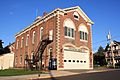
Humane Fire Company
-

Continental Stove Works


See also
 In Spanish: Royersford para niños
