
Audubon, Pennsylvania facts for kids
Quick facts for kids
Audubon
|
|
|---|---|
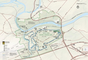
Audubon is located north of Valley Forge National Historical Park
|
|

Audubon
Location in Pennsylvania

Audubon
Location in the United States
|
|
| Country | United States |
| State | Pennsylvania |
| County | Montgomery |
| Township | Lower Providence |
| Area | |
| • Total | 4.60 sq mi (11.92 km2) |
| • Land | 4.59 sq mi (11.89 km2) |
| • Water | 0.01 sq mi (0.03 km2) |
| Elevation | 194 ft (59 m) |
| Population
(2020)
|
|
| • Total | 8,688 |
| • Density | 1,893.22/sq mi (730.91/km2) |
| Time zone | UTC-5 (EST) |
| • Summer (DST) | UTC-4 (EDT) |
| Postal code |
19403
|
| Area codes | 610 and 484 |
| FIPS code | 42-03544 |
Audubon is a special kind of community called a census-designated place (CDP). It is located in Lower Providence Township, which is part of Montgomery County, Pennsylvania, in the United States.
This place was named after a famous nature artist, John James Audubon. He lived here when he was a young man. In 2020, about 8,688 people lived in Audubon.
Geography
Audubon is in the southwestern part of Lower Providence Township. It's right across from Valley Forge National Historic Park. A special area called "The Peninsula" is part of Audubon. It's formed by two rivers, the Schuylkill River and Perkiomen Creek.
The U.S. Census Bureau says Audubon covers about 4.5 square miles (11.92 square kilometers). Most of this area is land, with only a tiny bit being water.
Demographics
| Historical population | |||
|---|---|---|---|
| Census | Pop. | %± | |
| 1990 | 6,328 | — | |
| 2000 | 6,549 | 3.5% | |
| 2010 | 8,433 | 28.8% | |
| 2020 | 8,688 | 3.0% | |
In 2010, most people living in Audubon were White (78.1%). There were also Black or African American people (5.2%) and Asian people (13.4%). About 2.3% of the population had Hispanic or Latino family backgrounds.
In 2000, there were 6,549 people and 2,379 households in Audubon. A household is a group of people living together. Many households (63.8%) were married couples. About 35.9% of households had children under 18 living with them.
History
Audubon is one of the villages that make up Lower Providence Township. This township has been around since the early 1700s. Other villages include Evansburg, Eagleville, and Providence Square. Audubon used to be called Shannonville.
Lower Providence Township is bordered by other townships and the Schuylkill River. The area is about 9,143 acres (37 square kilometers). The soil here is mostly red shale.
Many years ago, people tried to mine for lead and copper near Perkiomen Creek in a nearby area called Oaks, Pennsylvania. The lead mines started in 1800, and copper mining began in 1848. Thousands of tons of copper were found, but eventually, the mines ran out.
Shannonville was named in 1823 after a big family in the area. A post office was set up there, and a tavern called Jack's tavern opened. Because a Mr. Shannon was a successful pig farmer, the town was sometimes called "Hogtown."
The name Audubon was given to the town in 1899. This was to honor John James Audubon, who lived at a place called Mill Grove in the early 1800s.
Local landmarks


Audubon is located north of the Schuylkill River, right across from Valley Forge National Historical Park. It's also about 5 miles (8 kilometers) from King of Prussia, which is one of the biggest shopping malls in the United States. Here are some important places in Audubon:
Mill Grove
Built in 1762, Mill Grove was the first American home of the famous artist and nature lover John James Audubon. From 1803 to 1806, the fields and woods around Mill Grove inspired young Audubon to paint and draw birds.
Today, this 175-acre (0.7 square kilometer) property is an educational center run by the National Audubon Society. It helps people connect with nature. It's a safe place for birds and other wildlife, with over 7 miles (11 kilometers) of trails and views of Perkiomen Creek. The old stone farmhouse is now a museum. It shows original Audubon prints, paintings, and other items.
Audubon sold Mill Grove and moved to Kentucky. Mill Grove was later owned by the Wetherill family for 138 years. In 1951, Montgomery County bought it. Since 2003, the National Audubon Society has helped manage Mill Grove as the Mill Grove Audubon Center.
Walnut Hill (Pawlings Farm)
The land known as the Perkiomen Peninsula, especially Pawling Farm, was very important during the Valley Forge winter camp of 1777–1778. It helped protect the camp and was where food supplies were kept, which saved the Continental Army from starving.
Today, this area has different natural spaces like open meadows, forests, and wetlands. This makes Pawling Farm a great home for wildlife within the 3,500-acre (14 square kilometer) park. The park has unpaved trails, and the paved Schuylkill River Trail runs along one edge of the farm.
Schuylkill River Trail
This is a 13.5-mile (21.7-kilometer) trail that goes from Philadelphia to Oaks. It was built on an old railroad path and follows the beautiful Schuylkill River. It's a popular spot for biking, rollerblading, jogging, and walking. The U.S. Department of Interior calls it a National Recreation Trail. You can find parking and restrooms at places like Betzwood Park and Upper Providence Park.
Perkiomen Trail
The Perkiomen Trail is a 19-mile (30.6-kilometer) scenic trail that runs through the Perkiomen Creek Valley. It connects with the Schuylkill River Trail in Oaks and goes all the way to Green Lane Park, which is the county's largest park. Most of the trail is unpaved, made of cinder or stone.
This trail also follows an old railroad bed. It connects three county parks and two historic sites, including Mill Grove. It passes through ten towns and links to many local parks. You can also get to Valley Forge National Historical Park from this trail.
Audubon Elementary School
Audubon Elementary School is located near the center of Audubon. It was closed from the late 1980s until the mid-1990s. During that time, it was used as the town library and a YMCA. In the mid-1990s, it was renovated and reopened because many new homes were built in the area. There's a very old tree on its property, which is at least 200 years old. In 2017, the Methacton School District decided to close Audubon Elementary.
The Club at Shannondell (formerly General Washington Golf and Swim Club)
This club has an 18-hole championship golf course. It opened in 1965. The facility also has a swim club for families and a restaurant.
Audubon Inn
This large old building is at the corner of Park Avenue and Egypt Roads. It used to be a restaurant and an inn. Today, a law firm is located there. The property behind it was bought by CVS.
Education
The Methacton School District serves students in Audubon. Some parts of Audubon are served by Woodland Elementary School and Arrowhead Elementary School.
Skyview Upper Elementary School, Arcola Intermediate School, and Methacton High School serve all students in the district. Skyview Upper and Arcola Intermediate are in Trooper, and Methacton High is near Eagleville.
See also
 In Spanish: Audubon (Pensilvania) para niños
