
Ardmore, Pennsylvania facts for kids
Quick facts for kids
Ardmore, Pennsylvania
|
|
|---|---|

Schauffele Plaza
|
|
| Motto(s):
"The Main Street of the Main Line"
|
|

Location in Delaware County and the U.S. state of Pennsylvania
|
|
| Country | United States |
| State | Pennsylvania |
| Counties | Delaware, Montgomery |
| Townships | Haverford, Lower Merion |
| Area | |
| • Total | 1.97 sq mi (5.09 km2) |
| • Land | 1.97 sq mi (5.09 km2) |
| • Water | 0.00 sq mi (0.00 km2) |
| Elevation | 282 ft (86 m) |
| Population
(2020)
|
|
| • Total | 13,566 |
| • Density | 6,900.31/sq mi (2,664.01/km2) |
| Time zone | UTC-5 (EST) |
| • Summer (DST) | UTC-4 (EDT) |
| ZIP Code |
19003
|
| Area codes | 610 and 484 |
| FIPS code | 42-02896 |
Ardmore is a lively community in Pennsylvania, USA. It's a suburb located just west of Philadelphia. Ardmore is special because it sits right on the border between two counties: Delaware and Montgomery.
This area is known as a census-designated place (CDP). This means it's a community that the government counts for population, even though it's not officially a city or town. In 2020, about 13,566 people lived in Ardmore.

Contents
History of Ardmore
Ardmore has an interesting past. It was first called "Athensville" in 1853. But in 1873, the Pennsylvania Railroad changed its name to Ardmore. This happened because Ardmore is a stop on their important Main Line train route.
A company called Autocar Company moved its main office to Ardmore in 1899. They built a large factory there. This factory was a big part of the town until it closed in 1954. Today, Ardmore is a very popular place to live near Philadelphia.
Geography and Shopping
Ardmore covers about 5.1 square kilometers (almost 2 square miles) of land. It's surrounded by other towns like Wynnewood, Haverford, Gladwyne, and Havertown.
Downtown Ardmore
The heart of Ardmore is its downtown area. This area is mostly around Lancaster Avenue, Rittenhouse Place, and Cricket Avenue. You'll find many different shops, restaurants, and small businesses here.
Shopping Centers
Ardmore has several places to shop:
- The western part of downtown has shopping centers like Ardmore West and Ardmore Plaza.
- The eastern part of Lancaster Avenue has car dealerships, offices, and apartments.
- Suburban Square is a famous shopping center that opened in 1928. It was one of the first shopping centers in the United States!
- Ardmore was also home to the first suburban branch of a major department store, Strawbridge & Clothier, which opened in 1930.
Ardmore Neighborhoods
Ardmore has different neighborhoods, each with its own feel.
- The Merion Golf Manor neighborhood is named after the nearby Merion Golf Club.
- Ardmore Park is another neighborhood, sometimes called South Ardmore. It has Normandy Park and Chestnutwold Elementary School.
Local groups like the ArdWood Civic Association and the Ardmore Progressive Civic Association help bring neighbors together.
Ardmore's Population
Ardmore is a diverse community. Here's a quick look at its population:
| Historical population | |||
|---|---|---|---|
| Census | Pop. | %± | |
| 1990 | 12,646 | — | |
| 2000 | 12,616 | −0.2% | |
| 2010 | 12,455 | −1.3% | |
| 2020 | 13,566 | 8.9% | |
In 2010, most people in Ardmore were White (76.8%). There were also many Black or African American residents (12.9%) and Asian residents (4.1%). About 4.0% of the population had Hispanic or Latino family backgrounds.

Arts and Fun Things to Do
Ardmore has places for art and culture, and lots of spots for recreation.


Parks and Recreation Areas
You can find many parks and fun spots in Ardmore:
- Linwood Park
- Normandy Park
- The Ardmore Ice Skating Club
- Vernon V. Young Memorial Park, which has the Ardmore Ave Pool and a community center called "The Shack."
Other nearby parks include South Ardmore Park, Merwood Park, and Elwell Field. The Ardmore Post Office and the Ardmore Public Library are also important community places.
Historic Sites
Two important historical places in Ardmore are listed on the National Register of Historic Places:
- The Merion Golf Club East Course
- Pont Reading
Education in Ardmore
Students in Ardmore go to different schools depending on which township they live in.
- If you live in Lower Merion Township, you'll attend schools in the Lower Merion School District.
- If you live in Haverford Township, you'll go to schools in the School District of Haverford Township.
Famous Graduates
Lower Merion High School in Ardmore has had some very famous graduates, including:
- General Henry H. "Hap" Arnold (graduated 1903), a top general in the U.S. Army Air Forces during World War II.
- General Alexander M. Haig, Jr. (graduated 1942), who became the 59th United States Secretary of State.
- Kobe Bryant (graduated 1996), a legendary NBA basketball player and Hall of Famer.
Getting Around Ardmore (Transit)
Ardmore is well-connected by public transportation.
- The Ardmore train station serves both local commuter trains (SEPTA Regional Rail's Paoli/Thorndale Line) and longer-distance trains (Amtrak).
- The Norristown High Speed Line also runs through Ardmore, with stations like Ardmore Junction and Ardmore Avenue.
There used to be a streetcar line that went through Ardmore. It was later changed into a bus route, and part of the old line is now a special bus-only road.
Notable People from Ardmore
Many well-known people have lived in Ardmore, including:
- Henry H. "Hap" Arnold, a five-star general in the U.S. Air Force.
- Richie Ashburn, a famous baseball player for the Philadelphia Phillies and a Hall of Famer.
- Kobe Bryant, a basketball superstar for the Los Angeles Lakers.
- Kate Flannery, an actress known for playing Meredith on the TV show The Office.
- Alexander Haig, a U.S. Army general and former United States Secretary of State.
- Michael Sembello, a singer, guitarist, and songwriter.
In Popular Culture
Ardmore is even mentioned in popular culture! Lieutenant Joe Cable, a character from the musical South Pacific, is from Ardmore.
Images for kids
-
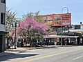
Schauffele Plaza
-
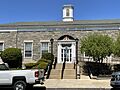
Ardmore post office
-
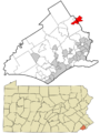
Location in Delaware County and Pennsylvania
-
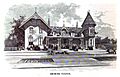
Drawing of Ardmore train station c. 1875
-
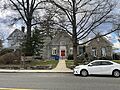
Ardmore Public Library, opened in 1899, part of the Lower Merion Library System.
-
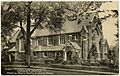
Ardmore Presbyterian Church, on an early postcard
See Also
 In Spanish: Ardmore (Pensilvania) para niños
