West Branch Schuylkill River facts for kids
Quick facts for kids West Branch Schuylkill River |
|
|---|---|

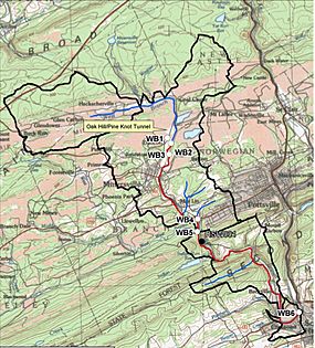
Topographic map of West Branch Schuylkill River watershed. The black line denotes the watershed boundary.
|
|
| Other name(s) | West Branch |
| Country | United States |
| State | Pennsylvania |
| Counties | Schuylkill |
| Cities | Buck Run, Glen Dower, Minersville, Pottsville, Cressona, Schuylkill Haven |
| Physical characteristics | |
| Main source | Buck Run, Pennsylvania, Schuylkill County, Pennsylvania 1,200 ft (370 m) 40°42′45″N 76°18′27″W / 40.71250°N 76.30750°W |
| River mouth | Schuylkill River Schuylkill Haven, Pennsylvania, Schuylkill County, Pennsylvania 600 ft (180 m) 40°38′3″N 76°10′51″W / 40.63417°N 76.18083°W |
| Length | 13 mi (21 km) |
| Basin features | |
| Basin size | 21 sq mi (54 km2) |
| Tributaries |
|
The West Branch Schuylkill River, often called just the West Branch, is a river about 13 miles (21 km) long. It flows into the larger Schuylkill River in central Schuylkill County, Pennsylvania, USA. A river like this, that flows into a bigger one, is called a tributary.
The area of land that drains water into the West Branch Schuylkill River is called its watershed. This watershed is about 21 square miles (54 square kilometers) in size. Several small towns and communities are located within this watershed. These include Beaver Meadows, Buck Run, Glen Dower, Minersville, Pottsville, Cressona, and Schuylkill Haven.
The river and its smaller streams have some water pollution from old mines. This is known as acid mine drainage. The West Branch starts near Interstate 81 and flows southeast. It passes through several water gaps, which are narrow valleys cut through mountains. Finally, it joins the Schuylkill River in Schuylkill Haven.
Journey of the West Branch River
The West Branch Schuylkill River begins from several small ponds. These ponds are located east of Interstate 81, close to the community of Buck Run.
River's Flow and Direction
From its start, the river flows towards the east-northeast. It runs alongside Valley Road and then Heckscherville Road. Near Heckscherville, smaller streams join it. These streams are Dyer Run, Wagner Run, and Wheeler Creek. They all flow into the river from its left side as you look downstream.
The river then turns south and southeast, flowing past Minersville. After that, it goes east through a narrow valley, like a small canyon. Here, Indian Run joins it from the right side.
Where the River Ends
After leaving the narrow canyon, the river turns south. It enters a valley that gets wider and wider. At Cressona, two more streams join the West Branch. Panther Creek flows in from the right side, and Beaver Creek joins from the left side. As the river reaches Schuylkill Haven, it finally merges with the main Schuylkill River on its right side.
 | Roy Wilkins |
 | John Lewis |
 | Linda Carol Brown |

