Darby Creek (Pennsylvania) facts for kids
Quick facts for kids Darby Creek |
|
|---|---|
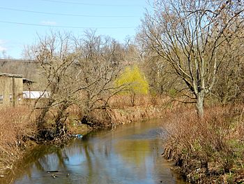
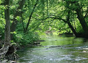
Darby Creek in Darby, Pennsylvania
|
|
| Other name(s) | Church Creek, Derby River |
| Physical characteristics | |
| Main source | small valley in Tredyffrin Township, Pennsylvania between 420 and 440 feet (130 and 130 m) 40°02′23″N 75°27′39″W / 40.0398°N 75.4607°W |
| River mouth | Delaware River in Delaware County, Pennsylvania 0 ft (0 m) 39°51′40″N 75°18′50″W / 39.8610°N 75.3138°W |
| Length | 26 mi (42 km) |
| Basin features | |
| Progression | Delaware River → Delaware Bay |
| Basin size | 77.2 sq mi (200 km2) |
| Tributaries |
|
Darby Creek is a cool waterway in Pennsylvania, about 26 miles (42 km) long. It flows through Chester, Delaware, and Philadelphia counties before joining the Delaware River. This creek has a large watershed, which is the area of land that drains into it, covering about 77.2 square miles (200 km2). Many smaller streams, called tributaries, flow into Darby Creek, including Cobbs Creek and Little Darby Creek.
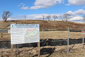
For much of its journey, Darby Creek's water quality isn't the best. In some areas, especially closer to its start, the water is cleaner. The lower part of the creek has been part of a big environmental cleanup project by the U.S. Environmental Protection Agency (EPA). This was needed because of past pollution from two old landfills.
Darby Creek starts in a narrow valley and then widens out as it gets closer to the Delaware River. It flows through different types of land, from old, hard rocks in the north to softer, newer deposits in the south. Historically, Native American tribes like the Lenni Lenape lived near the creek. Later, European settlers arrived and built many mills along its banks.
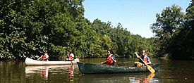
Today, groups like the Darby Creek Valley Association work to improve the creek and its surrounding areas. Parts of the creek are great for fishing, with different types of fish like redbreast sunfish, eels, and trout. Several important natural areas, such as the John Heinz National Wildlife Refuge, are found along Darby Creek, protecting wildlife and plants. You can even go canoeing on some parts of the creek!
Contents
Exploring Darby Creek's Path
Darby Creek begins its journey in a small valley in Tredyffrin Township, Chester County. It flows generally south and southeast, winding through several townships. Along the way, it picks up water from its first two named tributaries, Thomas Run and Little Darby Creek.
As the creek continues downstream, it passes through more towns and receives water from other streams like Miles Run, Camp Run, and Ithan Creek. It even flows alongside Interstate 476 for a bit. The valley around the creek becomes steeper and narrower as it flows past places like Clifton Heights and Landsowne.
Further south, Darby Creek leaves its narrow valley and flows through towns like Darby and Collingdale. Here, it meets its largest tributary, Cobbs Creek. The creek then enters the John Heinz National Wildlife Refuge, which is a very important natural area. In this refuge, Darby Creek flows through a large freshwater marsh, which is like a giant wetland.
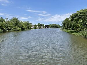
The last part of Darby Creek's journey is affected by the tides from the ocean. It winds through a large lagoon that was made deeper in the 1960s. Finally, after receiving its last tributary, Stony Creek, Darby Creek flows into the mighty Delaware River.
Key Tributaries of Darby Creek
Darby Creek has many smaller streams that feed into it. Some of the most important ones include Cobbs Creek, Little Darby Creek, Ithan Creek, and Muckinipattis Creek.
- Cobbs Creek is a big one, joining Darby Creek about 6.20 miles (9.98 km) from its mouth. Its watershed covers about 22.3 square miles (58 km2).
- Ithan Creek flows into Darby Creek about 17.90 miles (28.81 km) from its mouth.
- Little Darby Creek joins the main creek about 20.80 miles (33.47 km) from its mouth.
Understanding Darby Creek's Water Quality
The water quality in Darby Creek varies along its length. For most of its journey, the water quality is considered low. However, in the upper parts of the creek and its smaller streams, the water can be much cleaner.
A big reason for the lower water quality in some areas is the "Lower Darby Creek Superfund Site." This is a special area where past pollution from old landfills affected the creek. Because of this, about 10.9 miles (17.5 km) of the creek's lower section is considered "impaired." This means its water quality isn't good enough for all uses, often due to things like too much siltation (mud and dirt settling) and urban runoff (water flowing off city streets).
Scientists measure different things to check water quality. For example, they look at the water's pH (how acidic or basic it is), which for Darby Creek is usually slightly alkaline (around 7.3 to 7.8). They also measure things like dissolved oxygen, which fish need to breathe, and the levels of different chemicals like nitrogen and phosphorus. These measurements help experts understand the creek's health and what needs to be done to improve it.
Darby Creek's Landscape and Weather
Darby Creek starts high up, between 420 and 440 feet (130 and 130 m) above sea level. By the time it reaches the Delaware River, its elevation is 0 feet (0 m). This means the creek flows downhill, getting flatter as it nears the ocean.
The valley around Darby Creek is narrow at its beginning but gets much wider closer to the Delaware River. In some places, the creek's banks have been strengthened with large rocks to prevent erosion. The creek flows through two main types of land regions: the Piedmont Uplands in the north, which have older, harder rocks, and the Atlantic Coastal Plain in the south, which has softer, newer rock deposits.
The most common type of rock in the Darby Creek area is called the Wissahickon Formation. This rock comes from old sandstones and mudstones. You can also find other types of rocks like gneiss and schist. Interestingly, a type of rock called mica slate found in Marple Township was once used to make sharpening stones!
Darby Creek is often a fast-moving stream, with some riffles (shallow, rocky areas where the water flows quickly). It can even have some small areas of whitewater. In its upper parts, it acts like a "storm drain," quickly carrying away rainwater. But in its lower parts, it becomes a tidal estuary, meaning the ocean's tides affect its water levels.
There used to be three small dams on Darby Creek. However, they were removed in 2012. This was done to help prevent flooding and to allow fish to swim more freely up and down the creek. The average rainfall in the Darby Creek watershed is between 45 and 50 inches (110 and 130 cm) per year.
Soils Around Darby Creek
The land around Darby Creek has different types of soil. In the northwest, you'll find deep, well-drained soil that's good for farming. Most of the watershed has soil that's silty and can be shallow or deep, resting on brown schist and gneiss bedrock. In the southern part, the soil is silty and sandy, resting on coastal sediments. About 53% of the soil in the Darby Creek watershed is easily eroded, which means it can be washed away by water if not protected.
The Darby Creek Watershed Community
The watershed of Darby Creek covers about 77.2 square miles (200 km2). Most of this area is in Delaware County, but parts are also in Chester, Montgomery, and Philadelphia counties. Because its largest tributary, Cobbs Creek, drains a big area, the watershed is often called the "Darby-Cobbs watershed."
The Darby Creek watershed is a very developed area, with many suburbs of Philadelphia located within it. About 61% of the land is used for homes, while 11% is undeveloped and 10% is open space. There are also industrial and commercial areas. Around 484,000 to 500,000 people live in the watershed. The land is generally rolling (gently hilly) and densely populated.
Because so much of the watershed is developed, Darby Creek can be prone to storm surges and flooding during heavy rains. This is because paved areas and buildings don't absorb water like natural landscapes do, so more water flows quickly into the creek. Also, much of the older development was built before today's environmental rules, which can contribute to pollution.
A special environmental cleanup area called the Lower Darby Creek Area site is located near the creek. This site includes two old landfills that caused pollution. Major roads like Interstate 95 and Interstate 476 also cross through the watershed.
A Look Back at Darby Creek's Past
Darby Creek has a long and interesting history. It was officially named Darby Creek in 1979, but it was also known as Church Creek or Derby River in the past.
Before the 1900s
The first people to live near Darby Creek were the Lenni Lenape tribe. They used the creek for fishing, hunting, and traveling in canoes. They called the creek "Muckruton." The area was mostly forest, and the Lenape would clear parts of it for farming and safety.
In the 1600s, European settlers arrived. First came the Dutch, then the Swedish colonists in 1643, who even set up their government near the creek's mouth. The Dutch later took over, and then the English gained control in 1664. English settlers were drawn to the area because it was good for trade and had a productive landscape.
Early English settlers used Darby Creek's water power to run different kinds of mills, such as lumber mills, grist mills (for grinding grain), and textile mills. Most of these old mills are gone now, but some of the buildings that housed workers are still used as homes. By the late 1800s, new technologies made these old mills less important.
After the 1900s
The arrival of railroads in the late 1800s brought more growth to the Darby Creek watershed. Towns along the Pennsylvania Railroad grew a lot. In the early 1900s, farming was a major activity, though now it's only done in a few small areas upstream. Many railroads, like the Pennsylvania Railroad, crossed the watershed during this time.
In the 1930s, the United States Army Corps of Engineers worked on projects along Darby Creek, like repairing dikes (walls to hold back water) and digging ditches to control mosquitoes. After World War II, more and more homes were built in the watershed as cars made it easier for people to live farther from work.
In 1955, the Tinicum Wildlife Preserve was created, protecting an important marshland along the creek. Later, in the 1960s and 70s, two landfills operated near the creek, which later led to environmental concerns.
In 1999, Hurricane Floyd caused massive flooding in Darby Creek, damaging many homes. Some of these damaged homes were later torn down, and the land was turned into parks, like John Bartram Memorial Park.
Many studies and projects have been done to improve Darby Creek. Grants have been given to groups like the Darby Creek Valley Association to help restore the creek's banks and improve its health. The Darby Creek Valley Association is a group dedicated to protecting and improving the creek's watershed.
Cleaning Up the Lower Darby Creek Area
In 2001, the U.S. Environmental Protection Agency (EPA) added the Lower Darby Creek Area to a special list called the National Priorities List. This was because two old landfills, Folcroft and Clearview, had caused pollution in the soil, groundwater, and even fish.
Since then, the EPA has been working hard to clean up the area. In 2011 and 2012, they removed about 4,000 tons of polluted soil and sent it away safely. In 2014, they chose a plan for the Clearview landfill. This plan involves covering a large part of the landfill to prevent more pollution and collecting and treating any polluted water that seeps out.
More cleanup work happened in 2016 and 2017, where about 3,000 cubic yards of polluted soil were removed from homes nearby. The cleanup of the Clearview Landfill started in 2019 and is still going on. The EPA is also investigating the Folcroft landfill to decide how to clean up that area. It's important to know that people living nearby get their drinking water from public sources, not from the groundwater in this polluted area.
Wildlife and Nature in Darby Creek
Darby Creek is home to many different kinds of plants and animals. The main part of the creek is designated as a Coldwater Fishery and a Migratory Fishery. This means it's a good place for fish that like cold water and for fish that travel to different areas. Some parts are also a Trout Stocked Fishery, where trout are added for fishing.
In 2009, a survey found many fish species in the creek, including smallmouth bass, rock bass, and lots of redbreast sunfish. They also found stocked rainbow trout and brown trout. Many American eels were seen too! In the lower, tidal parts of the creek, you can find fish like mummichogs and striped bass. Brown trout even reproduce naturally in the creek's headwaters.
Two important natural areas, the Ithan-Darby Creek Wetlands and the Darby Creek Mouth Mudflat, are listed on the Delaware County Natural Areas Inventory. The John Heinz National Wildlife Refuge, which is a large tidal estuary along the creek, is also a very important site. It's a critical place for waterfowl (birds like ducks and geese) during their migrations.
These natural areas protect many special plant and animal species. For example, the Darby Creek Mouth Mudflat is home to 14 "species of concern" (plants that need protection). The Ithan-Darby Creek Wetlands have old fields, wet meadows, and areas along the stream called riparian buffers. While many native plants thrive, some exotic plants (plants not originally from the area) have also grown there. The population of white-tailed deer in the Darby Creek watershed is quite large.
Fun Things to Do at Darby Creek
Darby Creek offers several fun activities for people to enjoy!
Canoeing and Kayaking
About 18.0 miles (29.0 km) of Darby Creek is great for canoeing or kayaking. The difficulty of paddling ranges from easy to a bit challenging. You can canoe the upper parts of the creek after a heavy rain, but the lower 7.2 miles (11.6 km) are usually paddleable any time.
Trails and Parks
The Darby Creek Trail is a mile-long path in Haverford Township that follows the creek. It connects to Merry Place, a park with nature areas. There are plans for a longer multi-use trail along Darby Creek, running from Upper Darby Township to the borough of Darby. A part of this trail in Drexel Hill was finished in 2018.
Many public parks are located along Darby Creek. Some have big recreation areas with fields for sports like baseball and soccer. Others offer woodlands and nature trails for exploring. There are also eight golf clubs bordering the creek, which provide large areas of undeveloped land. The John Heinz National Wildlife Refuge is a fantastic place for hiking and canoeing. You can also find the Ridley Township marina at the lower end of the creek.
Fishing
Darby Creek is a popular spot for angling (fishing). The Pennsylvania Fish and Boat Commission and local sportsman groups stock the creek with fish every year, especially trout. So, if you like to fish, Darby Creek is a great place to cast a line!
 | Emma Amos |
 | Edward Mitchell Bannister |
 | Larry D. Alexander |
 | Ernie Barnes |


