
Little Darby Creek (Pennsylvania) facts for kids
Quick facts for kids Little Darby Creek |
|
|---|---|

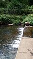
Little Darby Creek in Villanova, Pennsylvania
|
|
| Physical characteristics | |
| Main source | Radnor Township, Delaware County, Pennsylvania between 380 and 400 feet (120 and 120 m) |
| River mouth | Darby Creek in Radnor Township, Delaware County, Pennsylvania 223 ft (68 m) 40°00′47″N 75°23′17″W / 40.0130°N 75.3881°W |
| Length | 2.6 mi (4.2 km) |
| Basin features | |
| Progression | Darby Creek → Delaware River → Delaware Bay |
| Basin size | 3.51 sq mi (9.1 km2) |
| Tributaries |
|
Little Darby Creek is a small stream, or tributary, that flows into Darby Creek. You can find it in Delaware County, Pennsylvania, in the United States. It's about 2.6 miles (4.2 km) long and runs through an area called Radnor Township.
Contents
Where Does Little Darby Creek Flow?
Little Darby Creek starts its journey south of U.S. Route 30, close to the town of Wayne, Pennsylvania. It flows mostly south and southeast, passing through a spot called Mill Club Pond. Along its way, other smaller streams join it. These include Julip Run and Wigwam Run.
The creek then flows alongside Darby Paoli Road for a bit. Finally, after a short distance, it meets up with Darby Creek. This meeting point is about 20.8 miles (33.5 km) upstream from where Darby Creek itself ends.
How High is Little Darby Creek?
The land around Little Darby Creek changes in height. Where the creek begins, its source, the elevation is between 380 and 400 feet (120 and 120 m) above sea level. This is like saying it starts pretty high up!
As the creek flows downhill, it loses elevation. By the time it reaches its mouth (where it joins Darby Creek), the elevation is about 223 feet (68 m) above sea level.
What is the Land Like Around the Creek?
Little Darby Creek is located in a region called the Piedmont Uplands. This area has very old, hard rocks that were formed a long, long time ago. These rocks are from the Precambrian Era and Lower Paleozoic Era.
The ground you see is mostly made of two types of rock: felsic gneiss and mafic gneiss. There's also a small amount of serpentinite rock near where the creek ends.
What About the Soil?
The soil around Little Darby Creek is mostly deep and well-drained. It often has small pieces of gravel in it. This soil sits on top of bedrock made of rocks like gabbro and granodiorite.
In the middle part of the creek's area, the soil can be shallower. This soil rests on brown schist and gneiss bedrock. Most of the soil in this area can be easily washed away by water, which is called being "slightly erodible."
What is the Creek's Watershed?
The watershed of Little Darby Creek is the entire area of land where all the rain and snowmelt drain into the creek. This watershed covers about 3.51 square miles (9.1 km2).
Most of the land in this watershed is used for homes, but there are also some open, natural spaces. When there are big rainstorms, the creek can sometimes flood. Also, some of the tunnels or pipes that carry the creek's water (called culverts) are too small. This can make flooding worse.
The lower part of Little Darby Creek, about 1.73 miles (2.78 km) long, is considered "impaired." This means its water quality isn't as good as it should be.
History of Little Darby Creek
Little Darby Creek was officially named and added to the Geographic Names Information System on August 2, 1979. This system helps keep track of names for places like rivers and mountains.

Over the years, several bridges have been built across Little Darby Creek. One old bridge, made of stone arches, carries Darby Paoli Road over the creek. It's 24 feet (7.3 m) long and was built way back in 1840!
Animals and Plants in the Creek
The area around Little Darby Creek is a great place for fish. It's known as a Coldwater Fishery, meaning the water is cool enough for certain types of fish. It's also a Migratory Fishery, which means fish that travel long distances to lay their eggs use this creek. It's even approved for trout fishing!
Recently, a plant called kudzu has been growing a lot around the creek. Kudzu is a very fast-growing vine from Asia. It was brought to the United States in the 1930s to help stop soil from washing away. Even though frost kills the vines each year, the roots survive and the plant grows back. It can sometimes take over other plants.
Images for kids
-
Little Darby Creek in Villanova, Pennsylvania
-
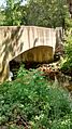
A bridge over Little Darby Creek at the Willows park
