Westwood, Chester County, Pennsylvania facts for kids
Quick facts for kids
Westwood, Pennsylvania
|
|
|---|---|

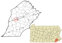
Location in Chester County and the state of Pennsylvania.
|
|
| Country | United States |
| State | Pennsylvania |
| County | Chester |
| Township | Valley |
| Area | |
| • Total | 0.5 sq mi (1.2 km2) |
| • Land | 0.5 sq mi (1.2 km2) |
| • Water | 0 sq mi (0.0 km2) |
| Elevation | 360 ft (110 m) |
| Population
(2010)
|
|
| • Total | 950 |
| • Density | 2,050/sq mi (790/km2) |
| Time zone | UTC-5 (Eastern (EST)) |
| • Summer (DST) | UTC-4 (EDT) |
| ZIP Code |
19320 (Coatesville)
|
| Area code(s) | 610 |
| FIPS code | 42-84248 |
| GNIS feature ID | 1191185 |
Westwood is a small community located in Valley Township, within Chester County, Pennsylvania, United States. It is known as a census-designated place (CDP). This means it is an area identified by the U.S. Census Bureau for statistical purposes. It is not an officially incorporated town or city. In 2010, the population of Westwood was 950 people.
Where is Westwood Located?
Westwood is found at 39°57′51″N 75°53′11″W / 39.96417°N 75.88639°W. It sits just west of the city of Coatesville. A main road called Valley Road, also known as Pennsylvania Route 372, goes right through the middle of Westwood. This road connects Coatesville with other nearby places like Pomeroy and Parkesburg to the west.
How Big is Westwood?
According to the U.S. Census Bureau, Westwood covers a total area of about 0.46 square miles (1.2 km2). All of this area is land. There are no large bodies of water within the community's boundaries.
See also
 In Spanish: Westwood (Pensilvania) para niños
 | John T. Biggers |
 | Thomas Blackshear |
 | Mark Bradford |
 | Beverly Buchanan |

