
Parkesburg, Pennsylvania facts for kids
Quick facts for kids
Parkesburg, Pennsylvania
|
|
|---|---|
|
Borough
|
|

Amtrak station
|
|

Location in Chester County and the U.S. state of Pennsylvania
|
|

Parkesburg, Pennsylvania
Location in Pennsylvania

Parkesburg, Pennsylvania
Location in the United States
|
|
| Country | United States |
| State | Pennsylvania |
| County | Chester |
| Area | |
| • Total | 1.27 sq mi (3.30 km2) |
| • Land | 1.27 sq mi (3.29 km2) |
| • Water | 0.01 sq mi (0.01 km2) |
| Elevation | 528 ft (161 m) |
| Population
(2020)
|
|
| • Total | 3,862 |
| • Density | 3,043.34/sq mi (1,174.78/km2) |
| Time zone | UTC-5 (EST) |
| • Summer (DST) | UTC-4 (EDT) |
| ZIP Code |
19365
|
| Area code(s) | 610 |
Parkesburg is a small town, also called a borough, located in Chester County, Pennsylvania, in the United States. In 2020, about 3,866 people lived here. It has its own special ZIP code, which is 19365.
Contents
History of Parkesburg
The story of Parkesburg began around 1734 with a building called the Fountain Inn. This inn was a popular place where travelers could stop and rest. Around 1836, the inn changed its purpose and became Parkesburg's very first post office.
In 1872, the state of Pennsylvania officially allowed Parkesburg to become a borough. A borough is like a small, self-governing town. The town was named after a well-known politician named John G. Parke. Today, the old Fountain Inn building is a private home.
Two important buildings in Parkesburg are listed on the National Register of Historic Places. These are the Parkesburg National Bank and the Parkesburg School.
Geography of Parkesburg
Parkesburg is located at 39°57′33″N 75°55′14″W / 39.95917°N 75.92056°W. This helps us find its exact spot on a map.
The United States Census Bureau says that the borough covers a total area of about 1.2 square miles (3.1 square kilometers). Almost all of this area is land.
Population and People
Parkesburg has grown over the years. Here is how its population has changed:
| Historical population | |||
|---|---|---|---|
| Census | Pop. | %± | |
| 1870 | 1,151 | — | |
| 1880 | 1,502 | 30.5% | |
| 1890 | 1,514 | 0.8% | |
| 1900 | 1,788 | 18.1% | |
| 1910 | 2,522 | 41.1% | |
| 1920 | 2,543 | 0.8% | |
| 1930 | 2,288 | −10.0% | |
| 1940 | 2,288 | 0.0% | |
| 1950 | 2,611 | 14.1% | |
| 1960 | 2,759 | 5.7% | |
| 1970 | 2,701 | −2.1% | |
| 1980 | 2,578 | −4.6% | |
| 1990 | 2,981 | 15.6% | |
| 2000 | 3,373 | 13.1% | |
| 2010 | 3,593 | 6.5% | |
| 2020 | 3,866 | 7.6% | |
| 2021 (est.) | 3,887 | 8.2% | |
In 2020, most people living in Parkesburg were non-Hispanic White (71.6%). About 8.3% were Black or African American. Around 9.5% of the people were of two or more races. Also, 9.8% of the population had Hispanic or Latino family backgrounds.
In 2010, the population was 81.1% non-Hispanic White. About 9.0% were Black or African American. Around 7.5% of the people had Hispanic or Latino family backgrounds.
Transportation in Parkesburg
_from_the_overpass_for_the_rail_line_between_Pennsylvania_State_Route_372_(First_Avenue)_and_Main_Street_in_Parkesburg,_Chester_County,_Pennsylvania.jpg)
As of 2022, Parkesburg has over 15 miles (24 kilometers) of public roads. Some of these roads are kept up by the Pennsylvania Department of Transportation (PennDOT). PennDOT is the state agency that manages roads. The rest of the roads are maintained by the borough itself.
Two main highways pass through Parkesburg. Pennsylvania Route 10 (PA 10) runs through the eastern part of town. Pennsylvania Route 372 (PA 372) goes through the center of town.
Parkesburg also has a train station. It is served by the Amtrak Keystone Service train line. The Parkesburg station is located at 501 Maple Street.
Education in Parkesburg
Students in Parkesburg attend schools that are part of the Octorara Area School District.
Notable People from Parkesburg
- Jesse Matlack Baker – He was a state senator for Pennsylvania.
- Howard Queen – He was a US Army colonel during World War I.
Images for kids
-
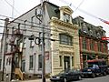
Parkesburg National Bank building
-
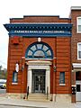
Farmers Bank of Parkesburg
-
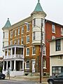
Parkesburg Arms Hotel
-
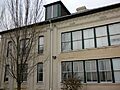
Parkesburg school


See also
 In Spanish: Parkesburg para niños
