Pomeroy, Pennsylvania facts for kids
Quick facts for kids
Pomeroy, Pennsylvania
|
|
|---|---|

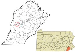
Location in Chester County and the state of Pennsylvania.
|
|
| Country | United States |
| State | Pennsylvania |
| County | Chester |
| Township | Sadsbury |
| Area | |
| • Total | 0.47 sq mi (1.21 km2) |
| • Land | 0.47 sq mi (1.20 km2) |
| • Water | 0.00 sq mi (0.01 km2) |
| Elevation | 484 ft (148 m) |
| Population
(2020)
|
|
| • Total | 1,085 |
| • Density | 2,333.33/sq mi (901.77/km2) |
| Time zone | UTC-5 (Eastern (EST)) |
| • Summer (DST) | UTC-4 (EDT) |
| ZIP code |
19367
|
| Area code(s) | 610 and 484 |
| FIPS code | 42-61968 |
Pomeroy is a small community located in Chester County, Pennsylvania, in the United States. It is known as a census-designated place (CDP). This means it's an area that looks like a town but doesn't have its own separate local government. In 2010, about 401 people lived there. By 2020, the population grew to 1,085 people.
Pomeroy was once the end point for the Pomeroy and Newark Railroad. This railroad carried passengers until 1928, when that service stopped.
Where is Pomeroy Located?
Pomeroy is in the southeastern part of Sadsbury Township. You can find it at these coordinates: 39°57′51″N 75°53′11″W / 39.96417°N 75.88639°W.
A main road, Pennsylvania Route 372, goes right through the middle of Pomeroy. This road connects Pomeroy to other nearby towns. It's about 3 miles (4.8 km) east of Coatesville. It's also about 1 mile (1.6 km) west of Parkesburg.
Land and Water Area
The United States Census Bureau measures the size of places like Pomeroy. They found that Pomeroy covers a total area of about 0.47 square miles (1.21 square kilometers).
Most of this area is land, about 0.47 square miles (1.20 square kilometers). A very small part, about 0.004 square miles (0.01 square kilometers), is water. This means only a tiny bit, less than 1%, is water.
How Many People Live in Pomeroy?
The United States Census Bureau counts how many people live in different places every ten years. This is called the Decennial Census.
Here's how Pomeroy's population has changed:
See also
 In Spanish: Pomeroy (Pensilvania) para niños
 | Toni Morrison |
 | Barack Obama |
 | Martin Luther King Jr. |
 | Ralph Bunche |

