
Honey Brook, Pennsylvania facts for kids
Quick facts for kids
Honey Brook, Pennsylvania
|
|
|---|---|

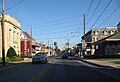
Corner of US 322 and Rt 10
|
|

Location in Chester County and the U.S. state of Pennsylvania
|
|

Honey Brook, Pennsylvania
Location in Pennsylvania

Honey Brook, Pennsylvania
Location in the United States
|
|
| Country | United States |
| State | Pennsylvania |
| County | Chester |
| Incorporated | 1891 |
| Area | |
| • Total | 0.48 sq mi (1.24 km2) |
| • Land | 0.48 sq mi (1.24 km2) |
| • Water | 0.00 sq mi (0.00 km2) |
| Elevation | 738 ft (225 m) |
| Population
(2020)
|
|
| • Total | 1,892 |
| • Density | 3,949.90/sq mi (1,525.10/km2) |
| Time zone | UTC-5 (EST) |
| • Summer (DST) | UTC-4 (EDT) |
| ZIP code |
19344
|
| Area codes | 610 and 484 |
| FIPS code | 42-35528 |
Honey Brook is a small town, also called a borough, located in Chester County, Pennsylvania, in the United States. In 2020, about 1,895 people lived there. The borough is surrounded by Honey Brook Township. Locals often call both areas simply "Honey Brook."
Contents
History of Honey Brook
How Honey Brook Started
Honey Brook Township was created in 1789 from a larger area called Nantmeal Township. In June 1813, a man named Andrew Boyer started planning a town. He named it Waynesburg, after a famous general from the Revolutionary War, Mad Anthony Wayne. Boyer began selling pieces of land for people to build homes and businesses.
Why the Name Changed
The town's name changed to Honey Brook in 1884. This happened because a railroad line was built from Philadelphia to Lancaster. There was another town named Waynesburg in western Pennsylvania. This caused confusion, and freight was often sent to the wrong place! To fix this problem, the town decided to change its name.
The name Honey Brook comes from a Welsh village called Nantmel. However, the English translation of Nantmel as "Honey Brook" is not quite right. The Welsh name actually means "Maël's valley," named after a prince from the 900s.
Becoming a Borough
In 1891, Honey Brook officially became a borough. This meant it could have its own local government. Almost everyone who owned a home signed a petition to make this happen. Becoming a borough helped the town improve many things.
Town Improvements
After becoming a borough, Honey Brook worked on making life better for its residents.
- In 1896, the town got public water.
- Electric streetlights were installed in 1915. Before that, gas lamps lit the streets.
- Old wooden boardwalks were replaced with brick, and then with concrete sidewalks. You can still find two brick sidewalks in the borough today!
When Honey Brook became a borough, about 600 people lived there. By the year 2000, the population had more than doubled.
The oldest church in Honey Brook is the Honey Brook United Methodist Church. The longest-running business is W.L. White's & Sons.
Geography
Honey Brook is located at 40°5′39″N 75°54′35″W / 40.09417°N 75.90972°W. It covers about 0.5 square miles (1.24 square kilometers) of land. The town sits on a ridge, which is a raised strip of land. This ridge is between the beginnings of the east and west branches of the Brandywine Creek.
Population Information
| Historical population | |||
|---|---|---|---|
| Census | Pop. | %± | |
| 1880 | 470 | — | |
| 1890 | 514 | 9.4% | |
| 1900 | 609 | 18.5% | |
| 1910 | 581 | −4.6% | |
| 1920 | 585 | 0.7% | |
| 1930 | 654 | 11.8% | |
| 1940 | 766 | 17.1% | |
| 1950 | 864 | 12.8% | |
| 1960 | 1,023 | 18.4% | |
| 1970 | 1,115 | 9.0% | |
| 1980 | 1,164 | 4.4% | |
| 1990 | 1,184 | 1.7% | |
| 2000 | 1,287 | 8.7% | |
| 2010 | 1,713 | 33.1% | |
| 2020 | 1,895 | 10.6% | |
| 2021 (est.) | 1,895 | 10.6% | |
In 2000, there were 1,287 people living in Honey Brook. There were 474 households and 337 families. About 41% of households had children under 18 living with them. The average household had about 2.7 people.
The population was spread out by age:
- Almost 30% were under 18 years old.
- About 33% were between 25 and 44 years old.
- About 12.5% were 65 years or older.
The average age in the borough was 33 years.
Transportation
_just_west_of_Pennsylvania_State_Route_10_(Conestoga_Avenue-Pequea_Avenue)_in_Honey_Brook,_Chester_County,_Pennsylvania.jpg)
As of 2010, Honey Brook had about 6.34 miles (10.20 kilometers) of public roads.
- About 1.52 miles (2.45 kilometers) were kept up by the Pennsylvania Department of Transportation (PennDOT).
- The borough itself maintained about 4.82 miles (7.76 kilometers) of roads.
Two main highways pass through Honey Brook:
- U.S. Route 322 runs through the middle of the borough. It is also known as Horseshoe Pike.
- Pennsylvania Route 10 goes through the northwestern part of town. This road is called Pequea Avenue and Conestoga Avenue.
Education
Honey Brook is part of the Twin Valley School District.
- Honey Brook Elementary Center is located nearby in Honey Brook Township.
- Twin Valley Middle School and Twin Valley High School are in Caernarvon Township, Berks County. They use Elverson as their postal address.
Notable People
Many interesting people have connections to Honey Brook:
- A.J. Alexy (born 1998), a pitcher in Major League Baseball.
- John Castle (1879–1929), a Major League Baseball outfielder and manager.
- Mat Madiro (born 1991), a drummer for a metal band.
- William W. McConnell (1834–1895), a businessman and politician in Pennsylvania.
- Tom Patton (born 1935), a catcher in Major League Baseball.
- Jim Spotts (1909–1964), a catcher in Major League Baseball.
- J. C. Wenger (1910–1995), a Mennonite religious scholar and professor.
Images for kids
-
US 322 near State Route 10
-
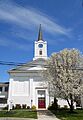
Presbyterian church
-
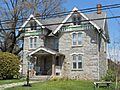
Honey Brook Borough Hall
-
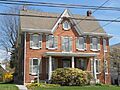
Another view of Honey Brook Borough Hall


See also
 In Spanish: Honey Brook para niños
