
Exton, Pennsylvania facts for kids
Quick facts for kids
Exton
|
|
|---|---|

Chester County Library at Exton
|
|

Location in Chester County and the state of Pennsylvania.
|
|

Exton
Location in Pennsylvania

Exton
Location in the United States
|
|
| Country | United States |
| State | Pennsylvania |
| County | Chester |
| Township | West Whiteland |
| Area | |
| • Total | 3.15 sq mi (8.17 km2) |
| • Land | 3.13 sq mi (8.10 km2) |
| • Water | 0.03 sq mi (0.07 km2) |
| Elevation | 312 ft (95 m) |
| Population
(2020)
|
|
| • Total | 5,622 |
| • Density | 1,797.89/sq mi (694.21/km2) |
| Time zone | UTC−5 (EST) |
| • Summer (DST) | UTC−4 (EDT) |
| ZIP Codes |
19341, 19353
|
| Area codes | 610 and 484 |
| FIPS code | 42-24440 |
Exton is a community in West Whiteland Township. It is located in Chester County, Pennsylvania, in the United States. In 2020, about 5,622 people lived here. Exton is known as a big shopping area in Chester County. It has the Exton Square Mall and Main Street at Exton, plus many other stores.
Contents
History of Exton
Exton is located where two important roads meet. These are U.S. Route 30 and Pennsylvania Route 100. Route 30 used to be called the Lancaster Road. It was a major path between Philadelphia and the western parts of the state. Route 100 was a local road going north and south to Pottstown.
Some people think Exton got its name because it was like an "X" on a map. This "X" marked the intersection of these two roads. However, it is more likely that the village was named after one of the places called Exton in the United Kingdom.
In the late 1940s, Exton became home to the Newcomen Society of the United States. This group built a campus with offices, a library, and a museum. They also had guest houses and a chapel. The Newcomen Society later closed down. However, their old campus is still an important landmark in Exton. It is now used as the headquarters for another business.
Geography and Climate
Exton covers an area of about 3.2 square miles (8.3 square kilometers). All of this area is land.
Exton's Climate
Exton has a type of climate called a "hot-summer humid continental climate." This means it has warm, humid summers and cold winters.
People of Exton
| Historical population | |||
|---|---|---|---|
| Census | Pop. | %± | |
| 2000 | 4,267 | — | |
| 2010 | 4,842 | 13.5% | |
| 2020 | 5,622 | 16.1% | |
In 2020, the community had 5,622 residents. Most people living in Exton are White (62.5%). About 31.5% are Asian, and 3.8% are Black or African American. A small number of people (1.3%) are Hispanic or Latino.
In 2000, there were 4,267 people living in Exton. The average household had about two people. The average family had almost three people. The median age was 35 years old. This means half the people were younger than 35, and half were older.
The median income for a household in Exton was $68,240. For families, it was $81,499. This shows that people in Exton generally have good incomes. Only a small number of people (2.9%) lived below the poverty line.
Economy and Jobs

Exton has a low unemployment rate, which means most people who want jobs can find them. The number of jobs is expected to grow by about 39% over the next ten years.
The opening of the Exton Square Mall helped Exton grow a lot. The population of West Whiteland Township increased from 7,900 in 1973 to over 16,000 by 2000. Many shopping centers and office buildings have been built since the mall opened.
Because of this growth, the West Whiteland Township Police Department was created. The mall brought so many people that the state police could not handle it alone. When the Exton Square Mall first opened, some stores in downtown West Chester closed.
West Pharmaceutical Services is a company based in Exton. They design and make special packaging for medicines that are injected.
Arts and Culture
The main building of the Chester County Library System is in Exton. It is located near the Exton Square Mall. The library building was named in honor of Congressman Paul B. Dague in 1971.
In 1982, the Exton library won an award for its Library Literacy Program. This program helped people who could not read or speak English well. It was the first program of its kind in Pennsylvania.
Education in Exton
Local Schools
All children living in Exton attend schools in the West Chester Area School District. Some students go to Exton Elementary School, which is in Exton. Others go to Mary C. Howse Elementary School.
For middle school, some students attend Fugett Middle School. Others go to Peirce Middle School. High school students attend either West Chester East High School or West Chester Henderson High School.
Some areas with an Exton mailing address are part of the Downingtown Area School District. This includes Downingtown High School East Campus and Lionville Middle School.
Other schools near Exton include Saints Philip and James, a Catholic school. The Church Farm School is also nearby.
Colleges and Universities
Several colleges have locations in Exton. Troy University has a learning site here. The offices of 21st Century Cyber Charter School are also in Exton. This is an online school known for its academic success.
Both Widener University and the Delaware County Community College have campuses in Exton. They are located in the Whiteland Business Park.
Public Libraries
The main library for the Chester County Library System is the Chester County Library and District Center. It is located in Exton.
Transportation and Travel

Exton has a good network of highways. These include U.S. Route 202, U.S. Route 30, and PA 100. These roads connect Exton to major cities like Philadelphia, Lancaster, and Wilmington.
Public Transit
Exton is served by train stations for public transportation. The SEPTA Regional Rail has stations at Whitford and Exton.
The Exton Transportation Center is a bus station located at the Exton Square Mall. It is a place where people can transfer between different bus routes. These buses connect Exton to places like West Chester, Coatesville, Paoli, and Eagleview.
Train service at Exton station is also provided by Amtrak. Their Keystone Service and Pennsylvanian trains stop here. SEPTA's Paoli/Thorndale Line also serves the station.
Notable People
- Kyle Lauletta – a quarterback for the New Jersey Generals
- Matt Ryan – a retired NFL quarterback
- Kerr Smith – an actor
Images for kids
-
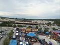
Exton Carnival 2014 at the Exton Square Mall
-
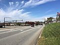
Northbound PA 100 past the interchange with U.S. Route 30
-
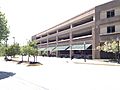
Exton Transportation Center located beneath the garage near the library


See also
 In Spanish: Exton (Pensilvania) para niños
