Compass, Pennsylvania facts for kids
Quick facts for kids
Compass, Pennsylvania
|
|
|---|---|
|
Unincorporated community
|
|

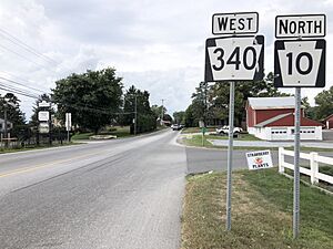
PA 10 and PA 340 through Compass
|
|
| Country | United States |
| State | Pennsylvania |
| County | Chester |
| Township | West Caln |
| Elevation | 518 ft (158 m) |
| Time zone | UTC-5 (Eastern (EST)) |
| • Summer (DST) | UTC-4 (EDT) |
| Area code(s) | 484, 610, 717 |
| GNIS feature ID | 1172273 |
Compass is a small place in West Caln Township within Chester County, Pennsylvania, in the United States. It's known as an unincorporated community. This means it's a group of homes and businesses that isn't officially a city or town with its own local government. Instead, it's part of the larger township.
About Compass, Pennsylvania
Compass is located where two important roads meet. These are State Route 10 and State Route 340. State routes are like main highways that connect different towns and areas across a state.
How Did Compass Get Its Name?
The community of Compass got its unique name from a local tavern. Long ago, this tavern had a sign with a picture of a compass on it. People started calling the area "Compass" because of this well-known landmark.
Black History Month on Kiddle
Famous African-American Pilots:
 | James B. Knighten |
 | Azellia White |
 | Willa Brown |

All content from Kiddle encyclopedia articles (including the article images and facts) can be freely used under Attribution-ShareAlike license, unless stated otherwise. Cite this article:
Compass, Pennsylvania Facts for Kids. Kiddle Encyclopedia.


