Octoraro Creek facts for kids
Quick facts for kids Octoraro Creek |
|
|---|---|

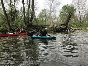
Kayakers on Octoraro Creek
|
|
| Country | United States |
| State | Pennsylvania |
| Physical characteristics | |
| Main source | Lancaster and Chester counties |
| River mouth | Susquehanna River 39°39′22″N 76°09′31″W / 39.6562°N 76.1587°W |
The Octoraro Creek is a 22.1-mile-long (35.6 km) stream in Pennsylvania and Maryland. It's a tributary (a smaller stream that flows into a larger one) of the Susquehanna River. The Octoraro Creek joins the Susquehanna about 9 miles (14 km) before the Susquehanna flows into Chesapeake Bay.
This creek starts with two main parts: the East Branch and the West Branch. These branches begin in Lancaster and Chester counties in Pennsylvania. The East Branch and the main Octoraro Creek form the southern border between these two counties. The creek then crosses the Mason–Dixon line (a famous historical boundary) and flows through northwestern Cecil County, Maryland. Finally, it meets the Susquehanna River.
The entire area of land that drains water into Octoraro Creek is about 208 square miles (540 km2). Because of its natural beauty, Octoraro Creek was named a Pennsylvania Scenic River in 1983. Long ago, a brick tunnel leading to Octoraro Creek was part of the Underground Railroad, a secret network that helped enslaved people find freedom.
Contents
East Branch Octoraro Creek
The East Branch Octoraro Creek is 18.1 miles (29.1 km) long. It begins near Christiana, Pennsylvania, where two smaller streams, Williams Run and Pine Creek, meet. Pine Creek actually forms part of the border between Lancaster and Chester counties for about a mile.
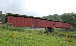
The East Branch continues to follow this county border. It flows through a deep, wooded valley. You can see the historic Mercer's Mill Covered Bridge as the branch passes underneath. The valley widens in some areas, like near Steelville and north of Homeville. Another stream called Muddy Run joins the East Branch. Eventually, the East Branch widens into the eastern part of Lake Octoraro. This lake is about 3 miles (5 km) northwest of Oxford, Pennsylvania.
West Branch Octoraro Creek

The West Branch Octoraro Creek is 15.3 miles (24.6 km) long and flows entirely within Lancaster County. It starts about a mile south of Green Tree. This branch is formed when Meetinghouse Creek, Mine Run, and a small unnamed stream (starting near Ninepoints village) all come together.
The West Branch flows under the Jackson's Sawmill Covered Bridge, which is northwest of Bartville. It then travels through a narrow valley for a few miles. The valley gets wider as the branch passes under Puseyville Road. You can also see the White Rock Forge Covered Bridge as the branch flows under Noble Road at Kings Bridge and at White Rock. Just like the East Branch, the West Branch also widens out into the western part of Lake Octoraro. This part of the lake is about two miles east of Oak Shade.
Main Octoraro Creek
The main part of Octoraro Creek begins where the East and West Branches meet. A large dam forms Octoraro Lake at this spot, near Pine Grove. Below the dam, there's a water treatment plant that cleans water for the Chester Water Authority.
The main creek flows under the Pine Grove Covered Bridge (on Forge Road). It then generally heads southwest. The creek passes under PA Route 272 at Kirks Bridge, which is less than three miles west of Nottingham.
As the creek gets closer to the Pennsylvania-Maryland border, it makes several turns and loops. One special horseshoe-shaped loop, where the creek first crosses into Maryland, gives its name to the Boy Scouts of America's Horseshoe Scout Reservation. This area is a mix of wilderness and an active gravel mine. The Scout Reservation also has the original Mason-Dixon Line mile-19 stone monument.
Octoraro Creek in Maryland
Once in Maryland, Octoraro Creek continues to wind southwest through a steep valley. It flows under large power lines that carry electricity from the Conowingo Hydroelectric Plant (a power plant that uses water to make electricity) towards Philadelphia.
The creek also passes under U.S. Route 1, a major road. It then flows past the site of a washed-out bridge called Porters Bridge. Near Rowlandsville, the creek goes under Doctor Jack Road and two old, unused railroad bridges. Finally, the Octoraro Creek passes under an active Norfolk Southern Railway bridge and MD Route 222.
The creek then reaches the Susquehanna River, just below the Conowingo Dam. Sometimes, when the hydroelectric plant isn't making power and the tide is low, the Octoraro Creek flows parallel to the Susquehanna for a short distance before joining it. However, when the hydroelectric plant is running, the water level can rise about six feet. This rise can cause the Octoraro Creek to flow backward for a bit, as far as the Route 222 bridge!
 | Toni Morrison |
 | Barack Obama |
 | Martin Luther King Jr. |
 | Ralph Bunche |

