
Chesapeake City, Maryland facts for kids
Quick facts for kids
Chesapeake City, Maryland
|
|||
|---|---|---|---|

Chesapeake City along the Chesapeake and Delaware Canal
|
|||
|
|||

Location of Chesapeake City, Maryland
|
|||
| Country | |||
| State | |||
| County | |||
| Incorporated | 1850 | ||
| Area | |||
| • Total | 0.72 sq mi (1.88 km2) | ||
| • Land | 0.53 sq mi (1.37 km2) | ||
| • Water | 0.19 sq mi (0.50 km2) | ||
| Elevation | 26 ft (8 m) | ||
| Population
(2020)
|
|||
| • Total | 736 | ||
| • Density | 1,388.68/sq mi (535.84/km2) | ||
| Time zone | UTC-5 (Eastern (EST)) | ||
| • Summer (DST) | UTC-4 (EDT) | ||
| ZIP code |
21915
|
||
| Area code(s) | 410 | ||
| FIPS code | 24-15950 | ||
| GNIS feature ID | 0589952 | ||
| Website | www.chesapeakecity-md.gov | ||


Chesapeake City is a small town in Cecil County, Maryland, United States. In 2020, about 736 people lived there.
The town was first called the Village of Bohemia or Bohemia Manor by an early settler named Augustine Herman. But in 1839, its name was changed to Chesapeake City. This happened after the Chesapeake and Delaware Canal (C&D Canal) was finished in 1829. Today, you can find many old homes in the town. Some of these have been turned into cozy bed and breakfasts, restaurants, and even a local history museum.
Contents
History of Chesapeake City
The C&D Canal was built right through the middle of Chesapeake City. This split the town into two parts: a north section and a south section. For many years, a drawbridge connected these two parts.
The Chesapeake City Bridge
In 1942, a large ship accidentally hit and destroyed the old drawbridge. A new bridge, called the Chesapeake City Bridge, was opened in 1949. This new bridge had to be very tall. It needed to let huge oil tankers pass underneath it easily.
Because the new bridge was so high and long, cars no longer had to drive into the town to cross the canal. This change meant fewer visitors came through the town. As a result, businesses in Chesapeake City faced challenges for many years.
Ukrainian Community and St. Basil's Church
Around 1911, many people from the Ukrainian community moved to Chesapeake City. They bought farmland on the edge of town and built their homes there. These new residents worked on the canal when it was made bigger in the 1920s. They also farmed, bringing their traditions and culture to Maryland's Eastern Shore.
In 1911, the Ukrainian Catholic Church planned to build a church and an orphanage in the area. St. Basil's Ukrainian Church opened a few years later. Before World War I, the St. Basil Orphanage began caring for children. Nuns from the Sisters of the Order of St. Basil the Great ran the orphanage until the 1970s. The church is still active today, serving the community with regular services.
Historic Places in Town
Chesapeake City is home to the Old Lock Pump House, Chesapeake and Delaware Canal. This important building from the C&D Canal was added to the National Register of Historic Places in 1966. The South Chesapeake City Historic District, which includes many historic buildings, was listed in 1974.
In the late 1900s, Chesapeake City was also known for Windfields Farm. This farm was one of the most important places in the world for raising thoroughbred racehorses.
Geography of Chesapeake City
Chesapeake City is located at 39°31′40″N 75°48′44″W / 39.52778°N 75.81222°W.
The United States Census Bureau says the town covers a total area of about 0.69 square miles (1.8 square kilometers). About 0.50 square miles (1.3 square kilometers) of this is land, and 0.19 square miles (0.5 square kilometers) is water.
Population Changes
The population of Chesapeake City has changed over the years. Here's how many people have lived there during different census years:
| Historical population | |||
|---|---|---|---|
| Census | Pop. | %± | |
| 1850 | 423 | — | |
| 1870 | 1,008 | — | |
| 1880 | 1,402 | 39.1% | |
| 1890 | 1,155 | −17.6% | |
| 1900 | 1,172 | 1.5% | |
| 1910 | 1,016 | −13.3% | |
| 1920 | 958 | −5.7% | |
| 1930 | 1,016 | 6.1% | |
| 1940 | 1,094 | 7.7% | |
| 1950 | 1,154 | 5.5% | |
| 1960 | 1,104 | −4.3% | |
| 1970 | 1,031 | −6.6% | |
| 1980 | 899 | −12.8% | |
| 1990 | 735 | −18.2% | |
| 2000 | 787 | 7.1% | |
| 2010 | 673 | −14.5% | |
| 2020 | 736 | 9.4% | |
| U.S. Decennial Census | |||
In 2010, there were 673 people living in Chesapeake City. About 15% of the residents were under 18 years old. The town had more females (55.1%) than males (44.9%).
Education in Chesapeake City
Chesapeake City is part of the Cecil County Public Schools System. There are three schools located in or near the town:
- Chesapeake City Elementary School
- A new, larger elementary school building was planned in 2019. It is designed to look like the area's bridge.
- Bohemia Manor Middle School
- Bohemia Manor High School
The Chesapeake City Branch of the Cecil County Public Library serves the town. It is located on Maryland Route 213. The library offers books, music, movies, computers with Internet, free Wi-Fi, and programs for all ages.
Transportation in Chesapeake City
_just_north_of_Maryland_State_Route_537_(George_Street)_in_Chesapeake_City,_Cecil_County,_Maryland.jpg)
The main way to get to and from Chesapeake City is by road. Maryland Route 213 is the most important highway. It connects the two parts of town using the Chesapeake City Bridge. MD 213 goes north towards Elkton and south to Cecilton. Other state highways in the town include Maryland Route 284, Maryland Route 285, Maryland Route 286, Maryland Route 342, and Maryland Route 537.
Notable People
- John Mabry: A former major league baseball player. He is currently a hitting coach for the Kansas City Royals.
Images for kids
-
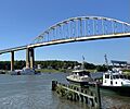
The Chesapeake City Bridge, connecting the two halves of town.
-
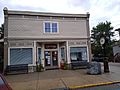
Town Hall
-
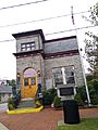
Former town hall


See also
 In Spanish: Chesapeake City (Maryland) para niños
