North East, Maryland facts for kids
Quick facts for kids
North East, Maryland
|
|||
|---|---|---|---|
 |
|||
|
|||

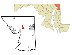
Location of North East, Maryland
|
|||
| Country | |||
| State | |||
| County | |||
| Settled | 1658 | ||
| Incorporated | 1850 | ||
| Area | |||
| • Total | 2.08 sq mi (5.38 km2) | ||
| • Land | 2.04 sq mi (5.29 km2) | ||
| • Water | 0.04 sq mi (0.09 km2) | ||
| Elevation | 16 ft (5 m) | ||
| Population
(2020)
|
|||
| • Total | 4,085 | ||
| • Density | 2,001.47/sq mi (772.71/km2) | ||
| Time zone | UTC-5 (Eastern (EST)) | ||
| • Summer (DST) | UTC-4 (EDT) | ||
| ZIP code |
21901
|
||
| Area code(s) | 410 | ||
| FIPS code | 24-56450 | ||
| GNIS feature ID | 0586223 | ||
| Website | http://www.northeastmd.org/ | ||
North East is a town in Cecil County, Maryland, United States. It is located between the big cities of Philadelphia and Baltimore. In 2020, about 4,085 people lived there.
The town was first settled in 1658. It became an official town in 1850. North East is home to some cool historic spots. These include the Turkey Point Lighthouse and the Gilpin's Falls Covered Bridge.
Contents
Geography of North East
North East is located in the state of Maryland. It covers a total area of about 2.11 square miles (5.46 square kilometers). Most of this area is land, with a small part being water.
Population and People
| Historical population | |||
|---|---|---|---|
| Census | Pop. | %± | |
| 1850 | 338 | — | |
| 1870 | 748 | — | |
| 1880 | 988 | 32.1% | |
| 1890 | 1,249 | 26.4% | |
| 1900 | 969 | −22.4% | |
| 1910 | 974 | 0.5% | |
| 1920 | 1,112 | 14.2% | |
| 1930 | 1,412 | 27.0% | |
| 1940 | 1,328 | −5.9% | |
| 1950 | 1,517 | 14.2% | |
| 1960 | 1,628 | 7.3% | |
| 1970 | 1,818 | 11.7% | |
| 1980 | 1,469 | −19.2% | |
| 1990 | 1,913 | 30.2% | |
| 2000 | 2,733 | 42.9% | |
| 2010 | 3,572 | 30.7% | |
| 2020 | 4,085 | 14.4% | |
| U.S. Decennial Census | |||
How Many People Live Here?
In 2010, there were 3,572 people living in North East. These people lived in 1,433 homes. About 901 of these were families. The town had about 1,734 people per square mile.
Many homes had children under 18 living there. The average age of people in North East was about 30.7 years old.
Schools in North East
North East has several schools for students of all ages. They are part of the Cecil County Public Schools system.
Public Schools
- North East Elementary School
- North East Middle School
- North East High School
- Cecil School of Technology
Private Schools
- The Tome School (for students from kindergarten to 12th grade)
Colleges
- Cecil College is a local college for higher education.
Getting Around North East
Main Roads and Highways
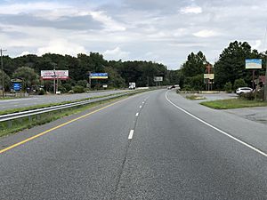
U.S. Route 40 is a major road that goes through North East. It connects the town to Elkton in the east and Perryville in the west.
Maryland Route 272 is another important road. It runs north and south through the center of town. This road can take you to Elk Neck State Park in the south. It also goes north towards Pennsylvania.
Interstate 95 is a big highway close to North East. You can get on I-95 from Maryland Route 272. This highway leads to Baltimore and Washington, D.C. to the south. It also goes to Wilmington and Philadelphia to the north.
Public Transportation
The Route 2 Cross-County Connection bus helps people get around. It is run by Cecil Transit. This bus connects North East to other nearby places. These include Elkton, Cecil College, and Perryville.
Historic Places to Visit
North East has some interesting historic sites. These places tell stories about the past.
- St. Mary Anne's Episcopal Church: This church was built a very long time ago, in 1742.
- Turkey Point Lighthouse: A historic lighthouse located nearby.
- Gilpin's Falls Covered Bridge: A beautiful old covered bridge.
Famous People from North East
Some notable people have connections to North East.
- Harry Anderson (1931–1998): He was a professional baseball player.
- George A. Palmer (1895–1981): He founded the Sandy Cove Conference Center.
See also
 In Spanish: North East (Maryland) para niños
 | Isaac Myers |
 | D. Hamilton Jackson |
 | A. Philip Randolph |


