Conowingo, Maryland facts for kids
Quick facts for kids
Conowingo, Maryland
|
|
|---|---|
 |
|
| Country | |
| State | |
| County | |
| Elevation | 289 ft (88 m) |
| Time zone | UTC-5 (Eastern (EST)) |
| • Summer (DST) | UTC-4 (EDT) |
| ZIP code |
21918
|
| Area code(s) | 410, 443, and 667 |
| GNIS feature ID | 590012 |
Conowingo is a community located in northwestern Cecil County, Maryland, United States. It is not an official town but a group of homes and businesses. The current community replaced an older one that was covered by water when a large dam was built.
Contents
What's in the Name?
The name "Conowingo" comes from the Susquehannock Native American language. It means "at the rapids," which makes sense because the original town was near fast-moving water.
A Look Back in Time
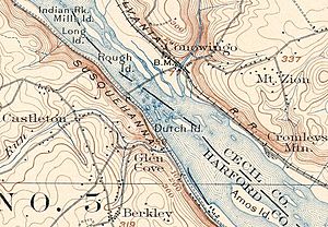
The first Conowingo was on the eastern bank of the Susquehanna River. It was located where the Conowingo Creek met the river. This spot was important because it was the first place on the Susquehanna River with rapids. These rapids made it hard for boats to travel upstream from the Chesapeake Bay. Because of this, an early canal was built here. The original Conowingo Bridge was also located in this area.
Around 1900, old Conowingo was a busy place with about 350 people. It had doctors, places to stay, and a bakery. There were also several stores and different types of tradesmen. For example, there were blacksmiths, shoemakers, and harness makers. The town even had a post office and several mills. A daily stagecoach helped people travel to nearby towns.
The Dam's Impact
The Conowingo Dam was built because the river dropped about 90 feet (27.4 meters) at the rapids. This big drop was perfect for creating hydroelectric power. When the dam was finished in 1928, the old town of Conowingo was flooded. Farmers and villagers had to move because of the huge new lake, called the Conowingo Reservoir.
On January 18, 1928, people watched from a nearby hill as their old village slowly disappeared under the water. The Conowingo Post Office was moved to a new spot on the hill above the dam.
Conowingo Village
A new area called Conowingo Village was created in 1928. This village was built on the Harford County side of the dam. It was first used to house the dam's managers and workers.
From the 1980s to 2000, the power company that owned the dam rented these homes to other people. In October 2000, the village was closed. The next year, in 2001, the power company gave the land to the Maryland Department of Natural Resources. The buildings were given to local fire companies for training exercises.
Important Places
While Conowingo is not an official town, it has some notable spots. Octorara Farm is a historic place that was added to the National Register of Historic Places in 1980. Other important places in the area include Rumbleway Farm, Hilltop Farm Inc., and several Christmas Tree farms.
Where is Conowingo?
- The original location of Conowingo was at 39°40′56″N 76°11′51″W / 39.68222°N 76.19750°W.
- The current location of the Post Office is at 39°40′36″N 76°9′44″W / 39.67667°N 76.16222°W.
 | Jackie Robinson |
 | Jack Johnson |
 | Althea Gibson |
 | Arthur Ashe |
 | Muhammad Ali |


