
Blackbird Creek (Delaware) facts for kids
Quick facts for kids Blackbird Creek |
|
|---|---|

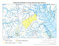
Blackbird Creek at Blackbird Reserve
|
|


|
|
| Other name(s) | Tributary to Delaware Bay |
| Country | United States |
| State | Delaware |
| County | New Castle |
| City | Townsend |
| Physical characteristics | |
| Main source | On the watershed divide between Blackbird Creek and the Chester River Dexter Corners, Delaware 75 ft (23 m) 39°19′25″N 075°41′46″W / 39.32361°N 75.69611°W |
| River mouth | 2 miles north of Taylors Bridge, Delaware Taylors Bridge, Delaware 0 ft (0 m) 39°26′19″N 075°34′27″W / 39.43861°N 75.57417°W |
| Length | 16.28 mi (26.20 km) |
| Basin features | |
| Progression | northeast |
| River system | Delaware River |
| Basin size | 8,022 ha |
| Tributaries |
|
| Waterbodies | Blackbird Pond |
| Bridges | Greenspring Road Oliver Guessford Road Railroad Crossing Blackbird Station Road US 13 Blackbird Landing Road DE 9 |
Blackbird Creek is a river in northern Delaware, United States. It is about 16.9 miles (27.2 km) long. This creek flows into the Delaware Bay.
Contents
The Creek's Journey
Blackbird Creek starts in two main parts. These parts are found north and south of Dexter Corners. This area is in southern New Castle County, Delaware. The creek then flows mostly northeast. It winds and turns a lot as it goes.
One part of the creek flows through Blackbird State Forest. The other part begins in a wet, wooded area on farmland. Both parts of the creek meet just before Blackbird Pond. This pond is southwest of the small village of Blackbird, Delaware.
After Blackbird Pond, a stream called Barlow Branch joins the creek from the left side. Further downstream, another stream, Sandom Branch, enters from the right. At this point, Blackbird Creek starts to feel the ocean's tides. It also gets much wider.
Near Blackbird Landing Road, Herring Run joins the creek from the left. This area has a lot of freshwater marshland. Even further downstream, Beaver Branch also enters from the left. Close to where Blackbird Creek meets the bay, three more tidal streams join from the right. These are Fishing Creek, Mill Creek, and Gravel Gut.
Blackbird Creek finally empties into the northern part of Delaware Bay. This spot is about 0.25 miles (0.4 km) south of the Appoquinimink River's mouth. It is also about 2 miles (3.2 km) north of Taylors Bridge.
Land Around the Creek
The land around Blackbird Creek is mostly forests and farms. Near its mouth, the creek is surrounded by large salt marshes. These marshes are home to special grasses. Two common types are saltmarsh cordgrass (Spartina alterniflora) and common reed (Phragmites australis).
The lower part of the creek is a protected area. It is part of the Delaware National Estuarine Research Reserve. This reserve helps protect the natural environment. Large parts of the creek's starting areas are in Blackbird State Forest. The small village of Blackbird is entirely within the creek's watershed. The city of Townsend is on its northern edge.
Changes to the Creek
Blackbird Pond is the only dam on Blackbird Creek. It used to be a millpond, which means it helped power a mill.
In 1829, this dam was part of a famous Supreme Court case. This case was important for how states could manage their own waterways.
Special Natural Areas
The Blackbird Creek area has unique natural spots called "Delmarva Bays." These are low, wet areas that can hold water. They are important breeding grounds for amphibians like frogs and salamanders. Many rare plants also grow here. Larger versions of these areas are sometimes called "Carolina Bays."
How the Land Was Formed
Blackbird Creek is in an area called the High Coastal Plain. This land was formed by material left behind by ancient glaciers. The very beginning of Blackbird Creek is in low, wet areas of this old glacial material. As the creek flows northeast, it passes through different types of soil and rock layers. It also carves out steep valleys along its path.
Images for kids
-

This map shows the path of Blackbird Creek in New Castle County, Delaware.
-
This map shows the entire area of land that drains water into Blackbird Creek.
.jpg)
.jpg)
