Beaver Branch (Blackbird Creek tributary) facts for kids
Quick facts for kids Beaver Branch |
|
|---|---|
| Other name(s) | Tributary to Blackbird Creek |
| Country | United States |
| State | Delaware |
| County | New Castle |
| Physical characteristics | |
| Main source | On divide between Beaver Branch and Appoquinimink River Pine Tree Corners, Delaware 55 ft (17 m) 39°24′31″N 075°39′30″W / 39.40861°N 75.65833°W |
| River mouth | Blackbird Creek about 0.5 miles northeast of Blackbird Landing, Delaware 0 ft (0 m) 39°23′44″N 075°37′09″W / 39.39556°N 75.61917°W |
| Length | 2.41 mi (3.88 km) |
| Basin features | |
| Progression | southeast |
| River system | Delaware River |
| Basin size | 2.24 square miles (5.8 km2) |
| Tributaries |
|
| Bridges | Union Church Road |
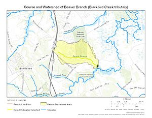
Beaver Branch is a small stream, about 2.41 miles (3.88 kilometers) long. It is located in the southern part of New Castle County, Delaware, in the United States. This stream is an important part of the local water system. It eventually flows into Blackbird Creek.
Where Does Beaver Branch Flow?
Beaver Branch starts its journey just east of a place called Pine Tree Corners. This area is also in southern New Castle County, Delaware. From its starting point, the stream flows generally towards the southeast. It continues this path until it reaches and joins Blackbird Creek. This meeting point is northeast of Blackbird Landing.
Understanding the Beaver Branch Area
The land around Beaver Branch is called its watershed. This is the area where all the rain and water drain into the stream. The Beaver Branch watershed covers about 2.24 square miles (5.8 square kilometers).
- Land Use: About 13% of this area is covered by forests. Forests are important for keeping the water clean. A larger part, about 63%, is used for farming. The rest of the land is used for other things.
- Rainfall: The watershed gets about 43.2 inches (109.7 centimeters) of rain each year. This rain helps keep the stream flowing.
Maps
 | Janet Taylor Pickett |
 | Synthia Saint James |
 | Howardena Pindell |
 | Faith Ringgold |


