Appoquinimink River facts for kids
Quick facts for kids Appoquinimink River |
|
|---|---|

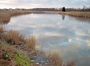
The Appoquinimink River in Odessa in 2006
|
|
|
Location of the mouth of the Appoquinimink River
|
|
| Country | United States |
| State | Delaware |
| Physical characteristics | |
| Main source | Near Townsend 23 ft (7.0 m)(at Wiggins Mill Pond, approx. 1 mi/2 km downstream of source) 39°22′52″N 75°44′14″W / 39.38111°N 75.73722°W |
| River mouth | Delaware Bay Near Odessa 0 ft (0 m) 39°26′52″N 75°34′49″W / 39.44778°N 75.58028°W |
| Length | 15 mi (24 km) |
| Basin features | |
| Basin size | 47 sq mi (120 km2) |
The Appoquinimink River is a river in northern Delaware, United States. It flows into Delaware Bay. This river is about 15 miles (24 km) long. It helps drain an area of 47 square miles (122 sq km) on the Atlantic coastal plain.
Contents
The River's Journey
The Appoquinimink River flows entirely within southern New Castle County, Delaware. It starts about 2 miles (3 km) west of Townsend, Delaware. The river generally flows east. It passes south of Middletown, Delaware and through Odessa, Delaware. Its journey ends at the northern part of Delaware Bay. This is about 3 miles (5 km) east of Odessa.
Lakes and Water Conditions
In its upper parts, the river flows through two man-made lakes. These are Wiggins Mill Pond and Noxontown Lake. The river is tidal up to the dam at Noxontown Lake. This means its water level changes with the ocean tides. Salinity, which is how salty the water is, from Delaware Bay usually affects the lowest 5 miles (8 km) of the river. The last 7 miles (11 km) of the river are considered navigable. This means boats can travel on them. The United States Army Corps of Engineers helps keep these parts clear for travel.
River Branches: Tributaries
The Appoquinimink River collects water from three smaller streams. These are called tributaries.
- Deep Creek flows from the north. It is about 4.2 miles (6.8 km) long. It was also known as the "North Appoquinimink River."
- Drawyers Creek also flows from the north. It is about 8.2 miles (13.2 km) long.
- Hangmans Run flows into the river from the south.
Land Around the River
The land around a river is called its watershed or drainage basin. This is the area where all the rain and water eventually flow into that river. In 2002, the United States Environmental Protection Agency collected data on how the land around the Appoquinimink River was used.
- About 54.9% of the land was used for agriculture. Farmers mainly grew soybeans, corn, and wheat.
- About 15.1% of the land was used for homes (residential areas).
- About 9.9% was wetland, which are areas like swamps or marshes.
- About 8.8% was covered by forests.
Protecting the River
In 2004, a non-profit group was started to help the Appoquinimink River. This group is called The Appoquinimink River Association. Their main goal is to protect the water and natural resources in the area around the river. They work to keep the river clean and healthy for everyone.
Historical Names of the River
The Appoquinimink River has had many different names throughout history. In 1950, the United States Board on Geographic Names officially decided on its current name. Some of the old names for the river include:
- Apequinemy River
- Apoquemene Creek
- Apoquiminy Creek
- Appoquinimunk Creek
- Minques Kil
- Opoquenin Creek
 | Jackie Robinson |
 | Jack Johnson |
 | Althea Gibson |
 | Arthur Ashe |
 | Muhammad Ali |


